Download
1 / 1
10 likes | 155 Views
The Crustal Dynamics Data Information System (CDDIS) is a dedicated data center supporting the international space geodesy community, providing easy and ready access to a variety of data sets, products, and information about them

E N D
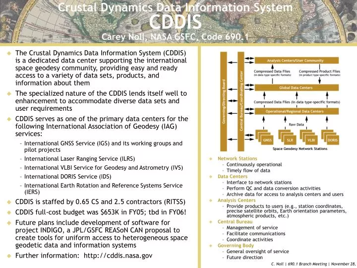
The Crustal Dynamics Data Information System (CDDIS) is a dedicated data center supporting the international space geodesy community, providing easy and ready access to a variety of data sets, products, and information about them The specialized nature of the CDDIS lends itself well to enhancement to accommodate diverse data sets and user requirements CDDIS serves as one of the primary data centers for the following International Association of Geodesy (IAG) services: International GNSS Service (IGS) and its working groups and pilot projects International Laser Ranging Service (ILRS) International VLBI Service for Geodesy and Astrometry (IVS) International DORIS Service (IDS) International Earth Rotation and Reference Systems Service (IERS) CDDIS is staffed by 0.65 CS and 2.5 contractors (RITSS) CDDIS full-cost budget was $653K in FY05; tbd in FY06! Future plans include development of software for project INDIGO, a JPL/GSFC REASoN CAN proposal to create tools for uniform access to heterogeneous space geodetic data and information systems Further information: http://cddis.nasa.gov Network Stations Continuously operational Timely flow of data Data Centers Interface to network stations Perform QC and data conversion activities Archive data for access to analysis centers and users Analysis Centers Provide products to users (e.g., station coordinates, precise satellite orbits, Earth orientation parameters, atmospheric products, etc.) Central Bureau Management of service Facilitate communications Coordinate activities Governing Body General oversight of service Future direction Crustal Dynamics Data Information SystemCDDISCarey Noll, NASA GSFC, Code 690.1