Download
1 / 15
160 likes | 361 Views
Proposed Roads and Access Roads. IRRPCC Meeting Albuquerque, NM November 8, 2011. Background. Clarification needed on applicability of these roads into the IRR Inventory Assignment given to IRRPCC last fall

E N D
Proposed Roads and Access Roads IRRPCC Meeting Albuquerque, NM November 8, 2011
Background • Clarification needed on applicability of these roads into the IRR Inventory • Assignment given to IRRPCC last fall • Work product developed from workgroups and provided to BIA and FHWA at meeting in St. Paul, MN week of 6/27/11. • BIA and FHWA, along with DOI Solicitor and FHWA Office of General Counsel utilized IRRPCC work product to develop recommendations.
Background • Schedule • Review of proposals by IRRPCC – Nov. 8-10 • Submittal of recommendations – Jan. meeting • Implementation • Review of existing inventory - start March 2012 end August 2012 • Impacts realized in FY12 inventory used for FY13 RNDF
Proposed Roads • Definition: • A proposed road or facility is any road/facility that will serve public transportation needs, meets the eligibility requirements of the IRR Program, and does not currently exist. 25 CFR 170.443. • Requirements • In order to have a proposed road placed on the IRR inventory and begin generating funding, a Tribe must submit the following to BIA-DOT/FHWA Quality Assurance Team (QA Team) for consideration:
Proposed Roads - Requirements • A Tribal Resolution identifying support for the facility and its placement on the IRR Inventory; • A copy of the Tribe’s Long Range Transportation Plan (LRTP) containing: • A description of the current land use and identification of land ownership within the proposed road’s corridor; and • A description of need and outcomes for the project/facility including a description of the project’s termini; and • The funding sources identified for the project. • If the landowner is other than the Tribe or the BIA, documentation indicating that the proposed road has been identified in the landowner’s LRTP, Statewide Transportation Improvement Program approved by FHWA, or other published transportation planning documents. • Certification that the Tribe held a public hearing, including documentation showing that the proposed road was - • An agenda item for the public hearing; and • Described to the public with sufficient clarity to allow the public to comment, in compliance with the applicable regulations and statutes. See generally 23 U.S.C. § 128 and 25 CFR 170.435-441.
Proposed Roads - Requirements • Documentation that the proposed road/project is feasible from a cost, environmental protection and engineering perspective. At a minimum, the following documentation must be submitted – • Cost Feasibility – Including the calculated costs of the project’s design, construction, operation, and post-construction maintenance, as well as identifying the funding sources that will be used to fulfill these requirements. • Environmental Feasibility – Identifying the degree to which the proposed alternative is considered preferable from an environmental protection perspective, including compliance with 23 USC § 138, 49 USC § 303 and the Section 4(f) Policy Paper, if applicable (1). • Engineering Feasibility – Identifying the proposed road’s functional classification and the benefits that will be provided to the traveling public upon completion. • FHWA’s “Procedural Guidelines for Highway Feasibility Studies,” shall be used as a guide for feasibility considerations (2). Additionally, the Tribe’s total funding requirements for all its previously approved proposed roads present on the IRR inventory at the time the new proposed road is submitted will be considered when determining cost feasibility. • Documentation identifying the party/public authority that will be responsible for maintenance of the road/facility after construction is completed, as required by 23 U.S.C. § 116. If a public authority will be responsible for maintenance, a resolution from the public authority indicating its agreement to maintain the road/facility. See 25 CFR 170.811. (1) See http://environment.fhwa.dot.gov/projdev/4fpolicy.asp (2) See http://www.fhwa.dot.gov/planning/corbor/feastudy.html
Proposed Roads • IRR Funding Generation • Proposed roads/facilities approved for addition to the IRR Inventory will generate the Cost to Construct (CTC) component of the Relative Need Distribution Factor Formula used to determine tribal shares for the IRR Program. A Vehicle Miles Traveled (VMT) component will not be calculated or included. • Quality Assurance Team • A QA Team composed of FHWA and BIA-DOT representatives will review all proposed road applications, documentation, may request additional information, and will determine whether the proposed road complies with this guidance and may be added to the IRR inventory. • Applicability to Existing Proposed Roads • The guidance identified above also applies to the proposed roads currently existing in the IRR Inventory. In order to remain in the inventory (or not be changed to a CN=0), the required documentation for those roads must be provided to the QA team for review and approval by April 1, 2012. A resolution of eligibility will be made for these roads prior to the determination of the FY 2013 tribal shares.
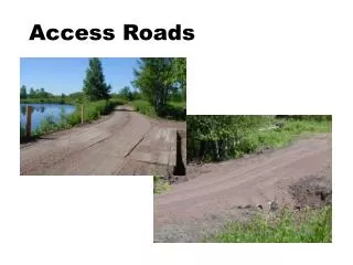
Access Roads - Definition • Contained in 23 USC 202(G) with further identification in 23 USC 202(G)(ii)(V) and 23 USC 202(G)(iii). • (G) National tribal transportation facility inventory. - • (ii) Transportation facilities included in the inventory. - For purposes of identifying the tribal transportation system and determining the relative transportation needs among Indian tribes, the Secretary shall include, at a minimum, transportation facilities that are eligible for assistance under the Indian reservation roads program that a tribe has requested, including facilities that - • (V) are primary access routes proposed by tribal governments, including roads between villages, roads to landfills, roads to drinking water sources, roads to natural resources identified for economic development, and roads that provide access to intermodal termini, such as airports, harbors, or boat landings. • (iii) Limitation on primary access routes. - For purposes of this subparagraph, a proposed primary access route is the shortest practicable route connecting 2 points of the proposed route.
Access Roads - Requirements • The submittal requirements for IRR roads are contained in 25 CFR 170. Roads that are physically located outside of a recognized boundary and that provide primary access to a recognized tribal need are called primary access roads. • All access roads are owned by others unless otherwise documented • In addition to the requirements identified in 25CFR170, a tribe must submit the following documentation in order to place the road on the inventory: • A completed Checklist for IRR Primary Access
Access Roads – Fund Generation • Existing Access Roads: If approved for inclusion in the IRR Inventory by BIADOT, will generate both the Cost to Construct (CTC) component and the Vehicle Miles Traveled (VMT) component of the Relative Need Distribution Factor (RNDF) Formula. • Proposed (non-existing) Access Roads: If approved for inclusion in the IRR Inventory by BIADOT, will generate only the Cost to Construct (CTC) component of the RNDF Formula. • Length of road: In order to determine the length of road that will generate the IRR Program funding, an Access Determination Line (ADL) will be established for each access road. The determination of the ADL and the extent/length of road that shall generate funding will be as follows:
Access Roads – ADL and Eligible Length • Indian Reservations: • ADL – federally recognized reservation boundary • Eligible funding length - The distance from the ADL to the intersection of a road with an equal or greater functional classification, but no more than 15 miles. • An inhabited or developed Alaska Native Village with a population more than 50% Alaska Native: • ADL – A 2-mile radius circle established from the geographic center of the Village.* (**) • Eligible funding length - The distance from the ADL to the intersection of a road with an equal or greater functional classification, but no more than 15 miles. • * If more than 25% of the Alaska Native Village population resides outside of the ADL, the tribe may request that the ADL be extended. • ** Only Class 3 and Class 5 roads within the 2-mile radius will be eligible to generate IRR funding.
Access Roads – ADL and Eligible Length • A tribally owned trust or fee parcel: • If located within an incorporated municipal boundary: • ADL – federally recognized tribal border/established property line • Eligible funding length - The distance from the ADL to the intersection of a road with an equal or greater functional classification, but no more than 15 miles. • If not located within an incorporated municipal boundary: • ADL – A 2-mile radius circle established from the geographic center of the parcel** • Eligible funding length - The distance from the ADL to the intersection of a road with an equal or greater functional classification, but no more than 15 miles. • ** Only Class 3 and Class 5 roads within the 2-mile radius will be eligible to generate IRR funding.
Access Roads • Applicability to existing access roads • The guidance identified above also applies to the primary access roads currently existing in the IRR Inventory. In order to remain in the inventory (or not be changed to a CN=0), the required documentation for those roads must be provided to the QA team for review and approval by April 1, 2012. A resolution of eligibility will be made for these roads prior to the determination of the FY 2013 tribal shares.
Assignments • To review and make further comment/recommendations on proposals