Download
1 / 20
200 likes | 207 Views
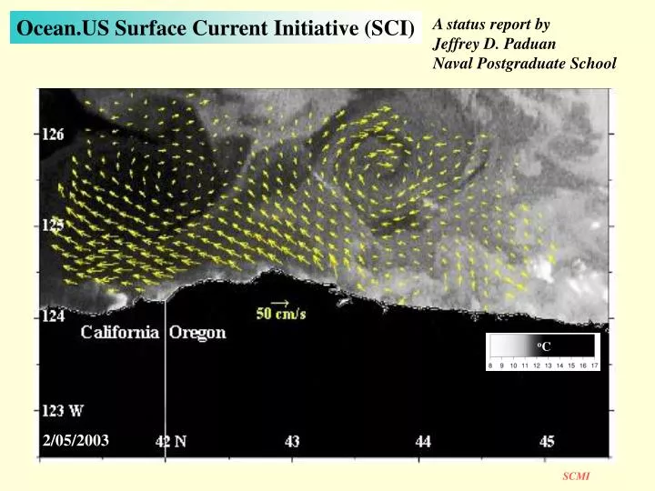
A status report by Jeffrey D. Paduan Naval Postgraduate School. Ocean.US Surface Current Initiative (SCI). o C. 2/05/2003. Ocean.US Surface Current Initiative (SCI)-Components. HF radar. HF Radar Advantages. Wide-area coverage Low cost Real-time True surface observation

E N D
A status report by Jeffrey D. Paduan Naval Postgraduate School Ocean.US Surface Current Initiative (SCI) oC 2/05/2003
Ocean.US Surface Current Initiative (SCI)-Components HF radar HF Radar Advantages Wide-area coverage Low cost Real-time True surface observation Improves model skill Other likely SCI components Satellite-based: feature tracking surface drifters altimetry Moored current meters Data assimilating circulation models
Ocean.US Surface Current Initiative (SCI)-Mission Statement Preamble Surface currents are an identified high priority product for coastal ocean observing systems. Surface Current Mappers (SCMs) that broadcast and then observe back-scattered radio signals from the ocean’s surface are now an operational technology that has been implemented in numerous locations worldwide. SCM technologies, using the same back-scattered radio signals, have also produced useful surface wave and vessel-tracking data in research applications. A nested network of SCMs installed along the coast of the United States, and used in conjunction with other observations and data-assimilative forecast models, will address issues critical to the seven major goals of IOOS. Mission This Surface Current Mapping Initiative (SCMI) will facilitate the implementation of a nested network of SCMs as part of the national observational backbone of the Integrated Ocean Observing System (IOOS). More specifically, the SCMI will (a) promote the installation of a national network, (b) develop a framework to coordinate its operation, data dissemination, and product generation, and (c) foster research that will enhance its operational products.
SCMI Steering Committee Members • Jeff Paduan (NPS; Chair) • Larry Atkinson (Ocean.US; ex officio) • Jim O’Donnell (U Conn) • Art Allen (USCG) • P. Michael Kosro (Oregon State Univ) • Scott Glenn (Rutgers) • Mark Bushnell (NOAA/NOS) • David Musgrave (U Alaska, Fairbanks) • Lynn (Nick) Shay (U Miami) • Libe Washburn (UC Santa Barbara) • Mark Luther (USF, NOAA/ACT) Biased toward experienced HF radar users Includes agency representatives First meeting: September 2003 Voluminous email exchanges since Drafting plan for wide community input, including March 04 ACT workshop
SCMI Issue Areas Governance–How to run the system Siting–Permissions and physical location restrictions Frequency Allocation–Need primary licenses; mutual interferences Products–Value added and QC procedures Research–Continuing improvements Vessel Tracking–Dual-use capability to track ships over EEZ ...see issues papers
Proposed Backbone Network Based on: Long-range systems (120-200km) Modest resolution(5-10km) ~5 sites per node ~100 sites(for minimal AK, HI)
Backbone Network The real thing! 222 km NEOS Radial Currents
L Backbone Network–a living example Significant Events A rapidly moving nor’easter Long-Term Trends Winter 2002 average
100 km Backbone Network–(another) living example Three (now 4) long-range sites capture mesoscale variability out to 150 km offshore and along 1/2 of the Oregon coastline Continuous observations for the critical coastal regime in which satellite AVHRR and altimetry seldom or cannot see P.M. Kosro
Backbone Network–(another) living example Poleward Equatorward/Offshore
Active Under Construction Being Purchased Coastal—13 MHz Bay—25 MHz CBI/TEESCoverage of HF-Radar Along Texas Coast
Unedited map of hourly surface-current vectors off Galveston TX (11/30/03 0900 UTC) Weak upcoast flow and an ebb tide from Galveston Bay.
Backbone Network–Costs *Needs to be broken into 3-5 year phased implementation
Backbone Network–Advantages Direct advantages Improved Search & Rescue Improved Mitigation of Hazardous Spills Improved Regional Circulation Models Ability to embed meaningful, high-resolution models Economies of scale HF radar-based mapping system is uniquely self contained Advantages to central management/coordination with distributed implementation Few advantages to distributed management/coordination
Backbone Network–Advantages through economies of scale All HF radar systems supply same product Radial current maps can be combined regardless of manufacturer Data is (practically) trivial Labor costs higher than hardware costs: optimize the people Common training needs; Shared knowledge & experiences Common required skills Driver’s license Tech #1 Basic electronic skills Scripting (e.g., PERL, ftp) Tech #2 Communications (wireless, modems) Calibration concerns are common Frequency and siting needs are common Remote communications needs are common
Backbone Network–Example Governance Science Board • Phased Innova-tions Governing Board • Present Standards • User Feedback Central Hub • Standard Products • Data Archive SCM Node Regional Assoc. • Tailored Products • High-res Products
Backbone Network–Pilot Study Plan Achieve phased implementation through a sequence of pilot studies Ready to begin immediately given the large number of research efforts underway using SCMs Should cover significant* area(s) Should include systematic approach to frequency and siting problems Should support parallel program in data assimilation Should support provisions to test ship tracking algorithms *to include several nodes so that the challenges of data exchange and reliability can be demonstrated
SCMI Conclusions–Timeline Jan04 Feb04 Mar04 Jun04 Oct04 AGU Ocean Sciences Meeting NOAA/ACT TOS/ALSO Meeting Detailed SCI outline and SCMI implementation plan to NORLC and public Detailed and vetted implementation plan available Begin national-scale, multiple node pilot studies
SCMI Conclusions–Jeff’s Jan04 Feb04 Mar04 Jun04 Oct04 AGU Ocean Sciences Meeting NOAA/ACT TOS/ALSO Meeting Detailed SCI outline and SCMI implementation plan to NORLC and public Detailed and vetted implementation plan available A national SCMI benefits everyone RAs will do the work RAs will get the credit IOOS will get the credit Users will get the products RAs can “densify” for the marginal costs It will cost less than the alternative of working from RAs outward It will actually happen Begin national-scale, multiple node pilot studies