Download
1 / 13
130 likes | 231 Views
Satellite Analysis Branch 2010 Year in Review. Gregory M. Gallina (SAB) NOAA Hurricane Conference November 30 2010. Milestones. Apr 2010 – ESPC freeze officially begins delaying operational transition of products; ADT v8.1.1, e-TRaP, MTCSWA, Prob. of Formation products.

E N D
Satellite Analysis Branch 2010 Year in Review Gregory M. Gallina (SAB) NOAA Hurricane Conference November 30 2010
Milestones • Apr 2010 – ESPC freeze officially begins delaying operational transition of products; ADT v8.1.1, e-TRaP, MTCSWA, Prob. of Formation products. • Apr 2010 – Dr. Davida Streett becomes SAB Branch Chief • Apr 2010 – DeepWater Horizon leads to loss of quality tropical analysts needed to man emerging marine pollution analysis desk • Summer 2010 – Cross-training of Precipitation analysts commences • Oct 2010 – loss of Tom Baldwin and contractors Robby Evans and Michelle Spampata • Oct 2010 – JTWC director expresses concern over potential loss of SAB Dvorak classifications in Eastern and Southern Hemisphere
ADT v8.1.1 Performance in the E. Pacific (2010) SAB 43% agreement 87% within ½ T-number ADT 55% agreement 94% within ½ T-number Credit: CIMSS
ADT v8.1.1 Performance in the E. Pacific (2010) Credit: CIMSS
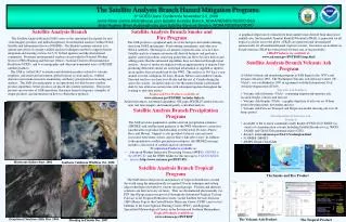
Volcanic Hazards Washington Volcanic Ash Advisory Center (VAAC) Responsibility to advise warning agencies (MWOs) and aviation industry of volcanic ash presence for safe aircraft operations • Use geo and polar sat imagery to define location and motion of ash • Use multiple dispersion models to make 6, 12 and 18hr forecast for location of volcanic ash • Generate txt (VAA) and graphic (VAG) products • Use geo and polar sat imagery to define 3D location and motion of volcanic ash • Use dispersion models to make 6, 12, and 18hr forecast • Generate txt (VAA) and graphic (VAG) of obs and fcst of volcanic ash locations Soufriere Hills Eruption 10 Feb 2010 Awips ID: VAASAB 1-2Planet ID: Nesdis_volcash Web: www.ssd.noaa.gov/VAAC GTS: FVXX?? KNES (?? = 20-27)
Fires and Smoke/Air Quality • Scans geo and polar imagery (vis, 3.9um and 11um) for heat signatures related to fires, rejecting suspected/confirmed power plants, factories, smelters, lava, etc. • Quality checks automated fire detect algorithms: ABBA, FIMMA and MODIS • Draws observed smoke produced by the fires determining density: thin, moderate or dense, which are assigned numerical value (5, 16 and 25 ug/m^3). • Provides location and duration of smoke producing fires as input to the Hybrid Single-Particle Lagrangian Integrated Trajectory (HYSPLIT) model, which produces the 48 hour forecast movement for NWS AQ forecast. • Produces 2x daily smoke txt product describing large areas of smoke, haze, and other AQ seen in vis imagery including current location, source • - This includes ANY resuspended Sand, Dust, Salt or Soils 1-2Planet ID: Nesdis_volcash Web: HMS/GIS/KML: www.osdpd.noaa.gov/ml/land/hms.html Smoke Txt: www.ssd.noaa.gov/PS/FIRE/current_text.html Awips ID: none GTS: none
Wildfires Are Not Always the Biggest AQ ThreatAgricultural and Prairie Fires Large amounts of smoke Numerous fires Flint Hills Event 2006 Numerous ag-fires producing thin smoke can make an overall area of dense smoke causing visibility and air quality problems.
Fire, Smoke, Dust Air Quality Products www.firedetect.noaa.gov/viewer.htm www.ssd.noaa.gov/PS/FIRE/hms.html www.ssd.noaa.gov/PS/FIRE/smoke.html SATURDAY APRIL 11, 2009 DESCRIPTIVE TEXT NARRATIVE FOR SMOKE/DUST OBSERVED IN SATELLITE IMAGERY THROUGH 0015Z APRIL 12, 2009 Central Plains: A large number of fires were again observed over eastern Kansas and eastern Oklahoma. However, smoke detection was limited as extensive cloud cover moved into the area in the afternoon and evening. Mexico: Blowing dust was kicked up this afternoon and evening in northern Mexico along the Coahuila/Durango border and streaming to the northeast toward Del Rio. Gulf of Mexico: A vast area of smoke from the numerous agricultural fires in the Yucatan and surrounding areas has lifted north across the Bay of Campeche and covers much of the western Gulf, reaching nearly to the western Louisiana coast. The smoke is moderately dense to dense over the Bay of Campeche and as far north as about 25N. Ruminski www.ssd.noaa.gov/PS/FIRE/kml.html
Precipitation Hazards: Satellite Perspective Support NWS WFO/RFCs except AK Via SPENES Change in focus of SPENES: Example of SPE graphic • Produce a mesoscale discussion of precip and flooding potential with a satellite analysis emphasis • Provide short term outlook and confidence factor • Annotated web graphic for SPE • Automated satellite estimates • Direct conference via 1-2 Planet Awips ID: SPENES 1-2 Planet ID: Nesdis GTS: TXUS20 KNES Web: www.ssd.noaa.gov/PS/PCPN/ Automated Sat. Estimate Example Hydro-Estimator
Marine Pollution Hazards • Analyze Synthetic Aperture Radar (SAR) and very high resolution visible and multispectral imagery to detect possible marine hazards, particularly surface oil and debris fields • Produce Marine Pollution Surveillance Reports (MPSR) to advise Coast Guard, Emergency Response Div. (ERD) of NOS, and Bureau of Ocean Energy Management, Regulation and Enforcement (BOEMRE) of the location of possible marine hazards for clean up and emergency response • Essential product used for numerous agencies including PotUS during the DeepWater Horizon Disaster in the Gulf MPSR Example Experimental Product please contact: Davida.Street@noaa.gov for further info on obtaining these reports in real time ALOS (SAR) Image June 26, 2010 1625Z