Download
1 / 25
250 likes | 419 Views
The benefit of EIGEN gravity field models for altimetry and vice versa Frank Flechtner , Roland Schmidt, Ulrich Meyer, Tilo Schöne, Sakia Esselborn, Christoph Förste, Richard Stubenvoll, Sergei Rudenko, Rolf König, Hans Neumayer, Markus Rothacher GFZ Potsdam. Motivation.

E N D
The benefit of EIGEN gravity field models for altimetry and vice versa Frank Flechtner, Roland Schmidt, Ulrich Meyer, Tilo Schöne, Sakia Esselborn, Christoph Förste, Richard Stubenvoll, Sergei Rudenko,Rolf König, Hans Neumayer, Markus Rothacher GFZ Potsdam
Motivation • The impact of modern global gravity field models derived from CHAMP • and GRACEon satellite altimetry is threefold: • Precise gravity fields are necessary prerequisite for the POD of • altimeter satellites at or below the noise level of the altimeter • instruments. • 2. Satellite-only geoid solutions with unprecedented spatial resolution • are essential for the determination of the sea surface topography • from altimeter data and precise altimeter satellite orbits. • 3. Time series of highly-accurate global gravity field models together • with altimetry are expected to give insight into separation of mass • and steric components of the ocean surface. See Talk S. Esselborn • “Basin Scale Mass Variations in the Atl. Ocean” • Finally, gravity information derived from altimetry is still an invaluable • input for the generation of high-resolution satellite, terrestrial and • altimeter data combination gravity models.
Content • Status of EIGEN (European Improved Gravity model of the Earth by • New techniques) gravity field model determination (collaboration • between GFZ and GRGS) • Influence of old and modern gravity fields on ERS-1/2 POD • Improvements in sea surface topography and sea surface currents • due to GRACE gravity models • Summary/Conclusions
Typical Ground-Based Coverage (before GPS Space Receiver became available) • Doppler, SLR, Doris, PRARE, … • One dimension at a time • Large coverage gaps • Very critical for LEOs
New Observation Techniques Satellite-to-Satellite Tracking high - low low - low Satellite Gravity Gradiometry Williamstown 1969, NASA Elmau 1979, ESA Erice 1985, IAG Coolfont 1991, NASA
The Dawn of a New Age CHAMP (since 2000) GRACE (since 2002) Germany USA-Germany GOCE (2007) European
EIGEN Satellite-only Modeling (1) Mean Satellite-only Gravity Fields: Gain in Resolution • Minimal resolvable wavelength dropped from 200-300 km to ~150 km. • Accumulated geoid error decreased to 1/3 than before, i.e. ~ 50 cm at this wavelength.
EIGEN Satellite-only Modeling (2) Mean CHAMP & GRACE Gravity Field: Gain in Accuracy 1cm @ 2800 km 1cm @ 700 km 1cm @ 270 km 1mm @ 600 km
EIGEN Combination Modeling (1) Combination of Satellite and Surface Gravity Data 1:ArcGP gravity anomalies (Forsberg, Kenyon 2004) 2: NRCan gravity anomalies (Véronneau 2003, personal communication) 3: AWI (Studinger, 1988) and LDO (Bell et al., 1999) gravity anomalies 4: NIMA altimetric gravity anomalies over the ocean 5: Geoid undulations over the oceans derived from GFZ MSSH minus ECCO Sea Surf. Top. (Stammer et al., 2002) 6: NIMA terrestrial gravity anomalies (if not covered by data sets 1 to 3) 7: NIMA ship-borne gravity anomalies over water depths less than 2000 m (white lines) White areas filled with EIGEN-3 data
EIGEN Combination Modeling (2) EIGEN-CG03C Gravity Anomalies
EIGEN-Modeling Gravity anomalies over Europe from different models GRIM-5S1 EIGEN-CHAMP03S EIGEN-GRACE03S EIGEN-CG03C
EIGEN-GL04C (1) The latest EIGEN Models • EIGEN-GRACE04S: Reprocessing of ~3y of GRACE data at GFZ using • improved ambiguity fixing method for determination of phase ambiguities • between GPS sender satellites and ground receivers • arc lengths of the adjusted orbits has been shortened from 1.5d to 1d • oceanic short-term mass variations corrected with baroclinic model • EIGEN-GL04C: Combination of • EIGEN-GRACE04S (GFZ, ~3y) • GRACE normal equations (GRGS (3y) • Lageos normal equations (GRGS, 3y) • Surface gravity data (~EIGEN-CG03C)
EIGEN-GL04C (2) contribution to the solution, full normal matrix: contribution to the solution, block diagonal matrix: contribution to the solution, numerical integration: kept separately (reduced from the full normal matrix): kept separately (stabilized and reduced from the full normal matrix): LAGEOS terr N 150 30 overlapping GRACE terr F terr B 70 120 degree/order 179 359 360
EIGEN-GL04C (3) Kaula‘s rule EIGEN-GL04C error cumulative EIGEN-GL04C signal 1 cm @ 220 km 10 cm @ 125 km EIGEN-GL04C error EIGEN-GL04C vs. GGM02C EIGEN-CG03C vs. GGM02C EIGEN-CG01C vs. GGM02C
EIGEN-GL04C (4) Unrealistic Meridional Striping much reduced in GL04C ! EIGEN-CG03C & EIGEN-GL04C minus terrestrial gravity data based geoid (m) EIGEN-CG03C EIGEN-GL04C
Altimeter satellite POD (1) • Goal: Test modern (GRACE) and some old geopotential models for • the determination of precise orbits of ERS-1 and ERS-2 altimetry • satellites. • ERS-1 data: SLR & SXO (24.03.1995 - 29.09.1995: 38 7d arcs) • ERS-2 data: SLR & PRARE (03.03.1997 - 02.09.1997: 36 7d arcs) • Validation: RMS orbital fit, Arc overlaps (2d) • NOTE: Detailed results on “Precise orbits of altimetry satellites ERS-1, ERS-2 and TOPEX/Poseidon” based on new EIGEN geopotential models covering the period 1991-2005 are shown on a poster by Rudenko et al. (Tuesday)
Altimeter satellite POD (2) Gravity Fields used in POD Test
Altimeter satellite POD (3) ERS-1 orbital fits and arc overlaps (cm) SLR & SXO global RMS and radial overlap improved by approx. 1-1.5 mm, when compared to GRIM results
Altimeter satellite POD (4) ERS-2 orbital fits and arc overlaps (cm) SLR global RMS and radial overlap components improved by ~0.5-1 mm and 0.4 mm, respectively when compared to GRIM results
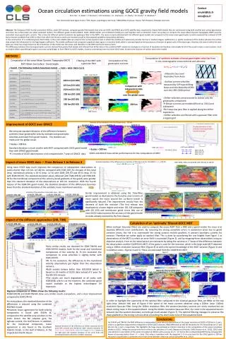
Improvements in Altimetry (1) • Dynamic Topography at the ocean surface can be derived from a • highly precise geoid model and a mean sea surface height (MSSH) • model derived from altimetry. • The geoid model is the satellite-only model EIGEN-GRACE03S • (nmax=150) which does not contain a-priori information from altimetry. • The GFZ-MSSH model is calculated from updated and harmonized • Topex and ERS1/2 data on a 2’x2’ grid using state of the art instrument • data and geophysical models including orbits based on EIGEN- • GRACE03S geoid model and a special SSB correction for Topex at the • end of the side A period. • The altimeter and geoid data have to be spatially filtered to take into • account the different spatial resolutions. Hamming, Hanning and • Gaussian tested to derive geostrophic surface currents.
Improvements in Altimetry (2) MSSH and GRACE Geoid GFZ-MSSH EIGEN-GRACE03S geoid Hanning filter with 400km half length width applied
Improvements in Altimetry (3) Dynamic Ocean Topography GFZ-MSSH – EIGEN-GRACE03S WOCE climatology
Improvements in Altimetry (4) Geostrophic Circulation EGM96S GRACE All major current systems tracked, e.g. Gulf Stream, Kuroshio Circumpolar Current
Improvements in Altimetry (5) Zoom: North Atlantic Geostrophic Surface Circulation GFZ-MSSH – EIGEN_GRACE03S Hydrobase climatology from Woods Hole Oceanographic Institute (1700 m) WOCE climatology (1750 m) • Very good agreement in strength and position of main current systems • See also Poster Esselborn et al. (“A Mean Ocean Dynamic Topography • Derived from Reprocessed Altimetry and the Latest GRACE Geoid Model”)
Summary/Conclusions Celebrate the 4th Birthday of GRACE on Friday! • GFZ has generated EIGEN gravity fields (as part of the GRACE SDS) • based on GRACE-only and GRACE plus terrestrial/altimetry gravity • combination fields (with GRGS). • Latest is EIGEN-GL04C which shows substantial improvement (OSTST). • Altimetry definitely benefits from these new models (POD, Dynamic • Topography, Surface Currents). • For more details see Posters Rudenko et al. and Esselborn et al.! • Remaining POD radial and XO differences will be hard to improve. • Further plans are to process longer GRACE time series and to include • more GRACE data and additional CHAMP data to EIGEN-GL04C • ERS-2 orbit: Reprocessing of PRARE data???