Download
1 / 31
320 likes | 674 Views
Permanent GPS Stations and their Influence on the Geodetic Surveys in Israel Gershon Steinberg Survey of Israel 1 Lincoln St. Tel-Aviv 65220, Israel Gilad Even-Tzur Mapping and Geo-Information Engineering Technion, Haifa 32000, Israel (consultant to SOI).

E N D
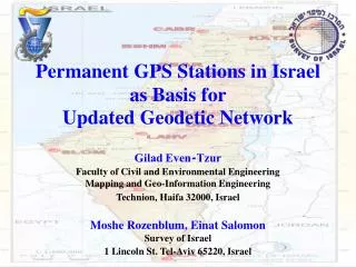
Permanent GPS Stations and their Influence on the Geodetic Surveys in Israel Gershon Steinberg Survey of Israel 1 Lincoln St. Tel-Aviv 65220, Israel Gilad Even-Tzur Mapping and Geo-Information Engineering Technion, Haifa 32000, Israel (consultant to SOI)
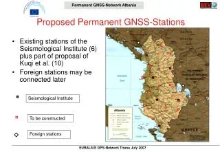
Permanent GPS Stations in Israel, October 2006 18 Stations Receivers: 7 Ashtech Z-XII 6 Leica SR500 5 Leica 1200 PRO Antennas: 9 Ashtech DM 6 Leica DM 2 Topcon CR4 1 Trimble DM Upgrade to GLONASS is coming up soon
Permanent GPS Stations in Israel, October 2006 11 stations are situated on stable roof tops NRIF
Permanent GPS Stations in Israel, October 2006 AREL DSEA SLOM YRCM NRIF 7 stations have geodynamic monumentation LHAV
The Control Center The GPS receivers are connected to a control center, equipped with master and backup servers, through IPVPN connections.
The GPS Data Flow 1 sec sampling rate Data is downloaded in real time The RINEX data is gathered into 1-hour interval files and posted on the internet
Operation Manager Software The network is controlled by the RTD software.
Permanent GPS Stations in Israel, October 2006 RAMO is the official IGS station in Israel All the data is processed at SOPAC (Scripps Orbit and Permanent Array Center) The data from RAMO and DRAG is also processed at EPN (EUREF Permanent Network)
The Permanent GPS Stations in Israel are called: APN Active Permanent Network
The VRS and RTK Options In order to enable GPS surveying over the entire state of Israel with direct connection to the permanent GPS network, VRS and RTK technologies are applied. The VRS and RTK are produced by the GEO++ software
The Plane Coordinates of the APN Points ►Each point from the APN network was connected by GPS observations to the nearest 1st order control points. ►A local datum transformation (3D) was calculated in order to assign plane coordinates to each permanent GPS station. The accuracy of the coordinates is equivalent to the accuracy of the classical 1st order control network (~6cm)
Permanent GPS Network A permanent GPS-based network is obviously more accurate, reliable and homogenous than the classical network. Permanent GPS Network Supreme Network
New Datum for APN A set of coordinates that was valid for GPS day 275 of the year 2004 (October 1st, 2004) in the ITRF2000 coordinate system was set as the fixed coordinates set for the permanent GPS stations This set of coordinates defined a new datum for APN, called IGD05 Israel Geodetic Datum 2005
Scale Network: Residual: 50km 5cm Horizontal residuals resulting from the seven parameters transformation between the ITRF2000 (IGD05) datum and the Israeli Grid
New Datum for Israel Grid A new set of plane coordinateswere adopted for the APN points by adding the residuals of the transformation. The new coordinates defined new datum for the Israeli Grid called: IG05 Israel Grid 2005
Official 7 Parameters Transformation IGD05 IG05 official 7 parameters transformation between the two systems
A flow chart for calculating new control points in IG05 coordinate system
Geodetic Control Networks • The National Geodetic Control Network will be defined as 3D control. • The network is based on the Permanent GPS stations of Israel (constitute the higher order). - Primary 3D class G - Secondary classes: S: horizontal coordinates. E: ellipsoidal heights.
Horizontal Control • The primary objective of the horizontal control network is to serve the cadastral surveys. • The goal is to define the cadastral boundaries with an accuracy of 5cm (95%).
National Control Network Classification and Required Accuracy
Vertical Control Ellipsoidal Control • There is neither practical possibility nor actual need to maintain a country-wide vertical orthometric control network. • SOI will maintain vertical ellipsoidal height control network.
National Control Network Classification and Required Accuracy
Orthometric control • The transition to ellipsoidal heights only, is premature yet. • The orthometric heights will be used as having a local datum. • HL can be measured either by geometric leveling, trigonometric leveling or GPS based on local benchmarks. • HS (statutory heights) measured by GNSS and official geoid undulations model (OGUM).
THE IDEA OF OFFICIAL GEOID UNDULATIONS MODEL (OGUM) AS A SUBSTITUTE FOR ORTHOMETRIC CONTROL • A very important objective of the leveling network is to bring consistentidentical heightsby every surveyor. • There is no need to wait for the "perfect" geoid model. • We suggest declaring the best available Geoid Undulations Model as an Official Model (OGUM). • The combination of OGUM with vertical Ellipsoidal Control based on CORS, produces a practical country-wide network of Orthometric Height Control, appropriate for most of the geodetic/surveying needs.
Vertical Local Orthometric Control Networks Levels and Required Accuracy • New: D is the horizontal distance. • HL1 and HL2 can be measured by leveling only. • HL3, HL4, HL5 can be measured by GPS also. • E1 will produce HS1 and E2 will produce HS2.
Experiments In Israel Goal:To examine the accuracy of orthometric height differences based on GPS measurements and OGUM in different locations in Israel. Two alternatives for OGUM: 1. ILUM1.0 - Israeli Undulations Model, Based on 750 Benchmarks. 2. GPM98B-Global Geopotential Model (Wenzel), contains few gravity data from Israel.
Experiments In Israel (cont.) • Six height-differences (between 4 adjacent benchmarks) were measured simultaneously by GPS (40 minutes' sessions). • The relative accuracy of the known orthometric height -differences, as well as the measured ellipsoidal height- differences, is 1-2cm.
Experiments In Israel(cont.) • Eight locations where the OGUM experiment was held in Israel. • The numbers denote the place's name as appears in the next table.
Experiments - Results • The RMS and the mean PPM values of the differences between the known orthometric height-differences and the orthometric height-differences obtained by GPS and the two alternatives for the OGUM.
Discussion For a reasonable orthometric control we actually need a height-differences accuracy of 25mm for benchmarks 1km apart: (25PPM). • We achieved this goal in all our experiments with the temporary Israeli OGUM. It was achieved also using the Global model, except for Eilat. • The results demonstrate the capability of the idea, for most of the engineering works. • Not instead of existing good networks. • A special benefit for areas were establishing a leveling network is practically impossible.