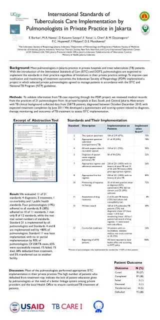
Download
1 / 19
190 likes | 422 Views
NSDI Standards and Emerging International Geospatial Data Standards - Avoiding a Clash. Richard Hogan U.S. Geological Survey Reston, Virginia June 23, 1998. rlhogan@usgs.gov. 703 648 5531. The Geospatial Data Problem. Data are hard to find Data are difficult to access

E N D
NSDI Standards and Emerging International Geospatial Data Standards - Avoiding a Clash Richard Hogan U.S. Geological Survey Reston, Virginia June 23, 1998 rlhogan@usgs.gov 703 648 5531
The Geospatial Data Problem • Data are hard to find • Data are difficult to access • Data are not current • Data are undocumented • Data are incomplete • Data are not in the right format
NSDI Objectives • Geospatial Data Standards • Digital Geospatial Data Framework • Digital Thematic Data • National Geospatial Data Clearinghouse
SDTSeXpress NSDI Standards • Metadata - for documenting, finding & assessing data • SDTS - for documenting, accessing & transferring data (archive) • Content standards - for semantic definition • Wetlands (classification) • Vegetation (classification) • Cadastral (data model)
Filling out the Matrixby adopting Non-FGDC Developed Standards
Filling out the Matrixby adapting General standards applicable to more than one theme Profiles
ISO 15046 Scope • Standardization in the field of digital geographic information. • This work aims to establish a structured set of standards for information concerning objects or phenomena that are directly or indirectly associated with a location relative to the Earth.
ISO 15046 Scope • These standards may specify, for geographic information, methods, tools and services for data management (including definition and description), acquiring, processing, analyzing, accessing, presenting and transferring such data in digital/electronic form between different users, systems and locations.
ISO 15046 Scope • This work shall link to appropriate standards for information technology and data where possible, and provide a framework for the development of sector-specific applications using geographic data.
Projects within ISO/TC 211 WG 1 Framework WG 2 Data Models WG 3 Data Administration WG 4 Services WG 5 Profiles (1) Reference Model* (2) Overview (3) Conceptual Schema Lang (4) Terminology (5) Conformance & Testing (R) Imagery & Gridded Data (7) Spatial Schema (8) Temporal Schema* (9) Rules for Application Schema (20) Spatial Operators* (10) Cataloging* (11) Ref by Coordinate (12) Ref by Geographic Identifier (13) Quality* (14) Quality Evaluation Procedure (15) Metadata* (16) Positioning Services* (17) Portrayal of Geographic Information (18) Encoding (19) Services (6) Profiles (R) Functional Standards
NSDI - ISO 15046 Relationships Data Documentation (metadata) FGDC CSDGM nearly 1:1 with ISO 15046-15 FGDC Content Standard for Digital Geospatial Metadata (FGDC-STD-001:1994) was used as the base document for WD 15046-15
NSDI - ISO 15046 Relationships Data Transfer NCITS SDTSis highly compatible with relevant parts of ISO 15046, so much so that SDTS Topological Vector Profile could become the first registered profile ofISO 15046
NSDI - ISO 15046 Relationships Data Semantics ISO 15046-10 defines a standard methodology for creating geospatial feature catalogs it extends the basic feature model found in SDTS such that SDTS Part 2 is ISO 15046-10 compliant some FGDC content standards will need to be redefined to be compliant (Feature Registry Project)
The Strategy • Promote NSDI standards as parts of ISO-15046 • Influence development of key parts of ISO-15046 • Link FGDC to ISO/TC 211
ISO/TC211 FGDC NCITS L1 The Links
Key Metadata Persons Rick Pearsall - USGS Dave Danko - NIMA Leslie Godwin - Census Bureau Norm Andersen - Lockheed-Martin
Collision Avoidance • Be aware of other activities • Link processes • Introduce and defend key concepts • Reverse engineer when necessary
Best Practices • Adopt existing standards • Adapt existing standards • Link domain specific standards to general IT standards • Get involved in international technical work as soon as possible • Avoid “end runs”