Download
1 / 42
430 likes | 558 Views
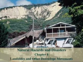
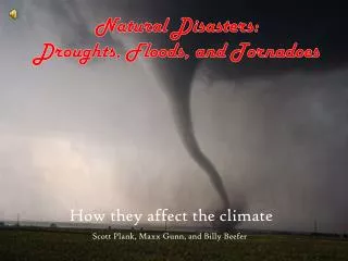
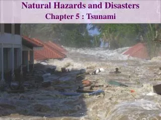
Natural Hazards and Disasters Chapter 12 Floods and Human Interactions. The Great Flood of 1993. Wet winter and spring saturated ground in northern Great Plains Heavy rainstorms continued for months Upper Mississippi River basin submerged for weeks – almost 100,000 square acres

E N D
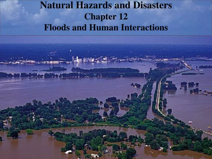
Natural Hazards and Disasters Chapter 12 Floods and Human Interactions
The Great Flood of 1993 Wet winter and spring saturated ground in northern Great Plains Heavy rainstorms continued for months Upper Mississippi River basin submerged for weeks – almost 100,000 square acres Wells were flooded and contaminated Six big floods in 20 years Governmental buyouts of flood-damaged homes, made way for public parklands 50 people died and more than $22 billion in damages
Development Effects on Floodplains • Early towns established along rivers for access to water and transportation • “Hydraulic civilizations” • Severe alterations of landscape through urbanization, logging, grazing, forest fires • Added sediment load to rivers • Increased size and damaging nature of floods
Urbanization • Increasing urbanization promotes increasing numbers of flash floods and higher flood levels • Wherever roads and buildings cover landscape, water forced to run off rapidly into nearby streams, sometimes through concrete channels • Driving through flooded roadway can be dangerous, even fatal • Force of water against car can wash it downstream • Deep erosion may not be visible underwater • Difficult to escape from submerged and sinking car
Fires, Logging, and Overgrazing Deforestation of watershed by fire, heavy logging or overgrazing cause increased sediment load Streams become choked with sediment, braided, steeper Forest soil soaks up water Fire removes soil protection, decreases soil permeability Clear-cut logging methods remove brush, form skid trails and logging roads that focus downslope drainage and add sediment to streams Grazing removes surface vegetation, increasing soil erosion
Mining • Mining can change sediment load, disrupt equilibrium of river • Large amounts of sand and gravel for construction use come from streambed mining • Reduced sediment supply in stream increases stream’s erosive energy • Channel becomes deeper (dangerous to structures) • Water table is lowered, reducing groundwater supplies • Reduces stream deposition downstream
Bridges Raise roadway above 100-year flood level Partial dam across floodplain, with narrow open channel under roadway bridge Deep water under bridge flows faster, causes erosion, undermines pilings supporting bridge
Levees Most common response to protect area from flooding is to artificially raise riverbanks with levee Almost always built on top of original natural levee at edge of stream channel Usually made with locally available, fine-grained sediments that are easily eroded in floods Higher-quality levees mix coarse gravel or face with riprap to resist erosion
Levee Failure More construction occurs behind levees, where people feel safe Overtopping or breaching of levees occurs frequently in major floods When large flood first breaches levee, water is clear and below sediment-load capacity erodes vigorously As breach deepens, water carries more sediment and water-surface slope decreases further erosion is limited
Levee Failure • Naturally flooding river drops coarse material on natural levee, finer material on floodplain, replenishing topsoil • River that floods over artificial levees damages topsoil: • By depositing sand and gravel over soil near channel • By eroding soil away farther from channel • Levee breach can lead to avulsion: redirection of main channel through breach, into lower path from which river can not escape • Failures can also occur from: • Bank erosion from river currents or waves • Slumps into channel • Piping or seepage through levee, sometimes reaching surface as sand boil
Levee Failure Levee Failure
Unintended Consequences of Levees • Every time a levee is built, also reduces width of flood-flow part of river and raises water level during flooding • Levees act to: • Eliminate storage of floodplain • Constrict flow and raise upstream water levels • Increase flood levels upstream and downstream
Wing Dams Constrict channel width to increase river depth for barge traffic during low flow Act to raise water level for any discharge Affect inferred recurrence interval for floods
Dams and Stream Equilibrium • Most large dams built by states, U.S. Army Corps of Engineers, Bureau of Reclamation • For Congress to appropriate funds for large dam, cost must be justified against perceived benefits: • Flood control • Hydroelectric power generation • Water stored for irrigation • Recreation
Dams and Stream Equilibrium Flood-control dams are built high enough to contain certain magnitude of expected flood Reservoirs behind dams eventually fill with sediment
Floods Caused by Failure of Human-Made Dams • Effect of dams is often to make people feel protected, more likely to build on floodplain • Dams in U.S. are highly variable in siting, design, construction quality, maintenance • Owned by • Federal or state agencies, less than 8% • Local agencies and utilities, about 19% • Private companies and individuals, about 59% • 1981 U.S. Army Corps of Engineers study found about 1/3 of 8,000 U.S. dams to be unsafe • More than 3,300 high and hazardous dams are within 1.6 km of downstream population center
Floods Caused by Failure of Human-Made Dams • Major floods from dams in narrow valleys occurred for variety of reasons: • Overtopping of major reservoir after prolonged rainfall • Seepage of water under dam • Subsurface erosion along faults • Poor design and engineering standards • Improper maintenance • Negligent operation • Landslide into reservoirs • Earthquakes that weaken earth-fill dams
Floods Caused by Failure of Human-Made Dams • 1952: Pecola Dam, 16 km upstream of Rapid City, South Dakota • People felt secure from floods, so homes built along creek • 1972: 37 cm of rain in six hours raised creek flow from typical few cubic meters per second to 1,400 cubic meters per second • Dam spillway clogged and raised reservoir level 3.6 m • Dam collapsed, sending flood right into Rapid City • 238 people killed, $690 million damage • Federal disaster aid was used to buy flooded properties for greenways, prohibiting building in floodplain • More recently, pressure increases to relax prohibitions
Reducing Flood Damage • Floods among deadliest and costliest weather-related hazards in U.S. • Annual costs of flood damage increased tenfold from 1929 to 2003 • Three Gorges Dam in China completed in 2006 • Devastating floods in 2007 • Landslides along reservoir upstream • Increased erosion downstream by faster, lower-silt-content water • Increased deposition upstream will silt up major port by 2016
Land Use on Floodplains • People settle on floodplains for cheap land, fertile soil, views • Tendency to underestimate risk: • Forget major floods soon, believe that similar floods unlikely again soon • Believe that flooding unlikely if has not occurred lately • Reduce flood damage by restricting floodplain development • Federal government pays for levees, provides disaster relief after floods, sometimes to rebuild at same unstable locations • Policies changed after 1993 Mississippi River flood • Began buying up floodplain land • Provided disaster relief funds only if moved out of floodplain • Prohibited new structures on flood plains, but exceptions being made • People feel that floodplain regulations infringe on personal rights • Individual’s choice to build on floodplain can infringe on many other individuals’ rights, and can be extremely costly to public
Flood Insurance Way to mitigate costs of flood damage to individual, to influence behavior to reduce future flood damages National Flood Insurance Program (NFIP) makes insurance available to those living on floodplains, at modest cost Insurance provided by federal government, purchased through private insurance companies 100-year floodplain is separated into floodway (stream channel and banks) and flood fringe (mostly floodplain) Communities must designate floodplain zones and enforce regulations, to be eligible for flood insurance
Flood Insurance • Flood insurance is good deal for those in flood-prone areas • Not a good deal for U.S. taxpayer, paying cost of losses • NFIP was $20 billion in debt in 2006, premiums not high enough to pay off • Participants in 2003 paid only 38% of actuarial risk rates • Few people even bother to purchase flood insurance • Before 1993 Mississippi River flood, only 5.2% of households in flood hazard area had purchased flood insurance • Flood insurance could be required before purchasing property or develop land • Insurance funds should be received only when building higher or relocating structure
Environmental Protection Intensity of future floods can be reduced by protecting rivers and watersheds Current restrictions: building or encroaching on floodway must not raise level of 100-year flood by more than 1 foot Waste disposal, storage of hazardous materials, soil-absorption sewage systems are prohibited in both floodway and flood fringe 1994 federal committee recommended moving levees along lower Missouri River back 600 m, floodplain being restored in wildlife-habitat project
Reducing Damage from Debris Flows Debris flows are most dangerous of downslope movements: sudden onsets, high velocities Many communities built on alluvial fans, deposited by debris flows Best solution is to avoid building in vulnerable areas Some fast-moving, watery debris flows may be covered under flood insurance Most landslides and ground movements are not covered by homeowner insurance
Early Warning Systems Can monitor conditions to provide warning when values reach known threshold for triggering event Warnings of increased hazard during prolonged or heavy rainfall Steep terrain leaves little time for evacuation once debris flow starts moving downhill Acoustic flow monitors detect low frequency rumble of ground shaking from debris flow, telemeter to sirens Inexpensive tripwire sensors are common but easily triggered in false alarms
Trapping Debris Flows • Build structures to minimize damage from debris flows • Walls to deflect debris flow to area with less development • Channels to contain debris flow into debris basin • Permeable grid dams upstream that stop boulders but allow water to drain
Case In Point Addition of Sediment Triggers Flooding: Hydraulic Placer Mining, California Gold Rush, 1860s First California gold miners used panning or sluicing to separate gold Later miners used high-pressure jets of water to hose gravels down into sluices Loose gravel was washed downstream in floods Central Valley rivers became choked with sediment, flooding farmland with gravel and causing catastrophic flooding for next 30-40 years Hydraulic mining outlawed in 1884
Case In Point Streambed Mining Causes Erosion and Damage: Healdsburg, California River-channel gravel mining lowered channel of Russian River by several meters over 50 years Lowering stream channel increased stream gradient, which increased its erosive power Russian River eroded orchards, vineyards and undercut bridge supports
Case In Point The Potential for Catastrophic Avulsion: New Orleans Levees built to protect New Orleans soon after original settlement on natural levee of Mississippi River After every flood, levees were built higher City spread into drained marshes of floodplains, causing further subsidence Mississippi River now sits above level of most of city Pumps work constantly to keep city free of water (below level of groundwater)
Case In Point The Potential for Catastrophic Avulsion: New Orleans Levees raise river above floodplain, exacerbating floods Over time, river builds delta seaward and builds its bed and natural levees higher Eventually, during flood, river breaks through natural levees to steeper, shorter path to sea, which takes over as new channel
Case In Point The Potential for Catastrophic Avulsion: New Orleans Distributary channel of Mississippi River, Atchafalaya River, began to take over main channel about 60-70 years ago U.S. Army Corps of Engineers built structure to send 30% of flow into Atchafalaya, use as flood regulator, but structure is continually damaged and threatened by large floods Avulsion of Mississippi River above New Orleans would be economically catastrophic for city
Case In Point The Potential for Catastrophic Avulsion: New Orleans
Case In Point A Long History of Avulsion: Yellow River of China Yellow River drains most of northern China Vigorous sediment supply from easily eroded silt of heavily agricultural loess plateau Lower reach of river flows through densely populated, cultivated alluvial plain Low gradient causes sediment deposition raises channel bottom causes frequent flooding and channel avulsion Flooding, avulsion and resultant famine in 1887 killed more than 1 million people San-men Gorge Dam, built in 1960 for flood control and power generation, is now filled with sediment, useless Flood level in 1996 was at all-time high
Case In Point Repeated Flooding in Spite of Levees: Mississippi River Basin Flood, 1993 Heavy rain continued from stalled storms through 1993 as ground saturated, reservoirs filled Flood crest moved downstream while rain continued Tributaries backed up, even flowed upstream Many places experienced multiple flood crests Largest flood on record for upper Mississippi by August Crushed rocks and sandbags used to raise level of levees Over 75% of locally- or state-built levees were damaged Levees intentionally breached upstream of Prairie du Rocher, to allow floodwaters to drain back into Mississippi River channel
Case In Point Repeated Flooding in Spite of Levees: Mississippi River Basin Flood, 1993
Case In Point Dams Can Fail: Failure of the Teton Dam, Idaho, 1976 Teton Dam was built to provide irrigation water, hydroelectric power, recreation and flood control Earth-fill design, with thin grout curtain, over intensely fractured rhyolite bedrock Few bedrock fractures filled, as concrete ran out Fill material was poorly compacted Dam was allowed to fill at almost three times usual rate Weeks later, two springs were discovered downstream Wet spot appeared on face of dam Later same morning, hole expanded until dam collapsed Flood killed 11 people, 13,000 livestock, cost government $1 billion in claims
Case In Point Dams Can Fail: Failure of the Teton Dam, Idaho
Case In Point Catastrophic Floods of a Long-Established City: Arno River Flood, Florence, Italy, 1966 River is channelized through city, with buildings immediately adjacent Major floods on average every 26 years Largest flood ever tore through small towns upstream at 60 km/hr before reaching Florence and raising water levels 6.2 m Water 1-6 m deep covered city, carrying contaminants such as heating oil 29 people died, destruction of priceless medieval, Renaissance art Problems compounded by deforestation, upstream dam construction
Case In Point Proposed Development on a Floodplain: Sacramento-San Joaquin Valley, California State of California proposed limiting development on flood-prone areas near Sacramento – fought by developers, arguing loss of people’s property rights Such building argued as not in public interest, as tax dollars bail out property owners when flooding occurs 1996-1997 El Nino brought torrential rains Ground became saturated Reservoirs filled Floodwaters covered 650 square km, including site of proposed Plumas Lakes community for 30,000 Additional consideration led U.S. Army Corps of Engineers to propose 30-m corridor of prohibited development along channel
Case In Point Alluvial Fans Are Dangerous Places to Live: Venezuela Flash Flood and Debris Flow, 1999 Torrential rains dumped almost 1 m of rain on slopes in two days Flash floods and debris flows inundated towns north of Caracas, burying houses and apartment buildings in debris up to 6 m thick Estimated 30,000 people killed, 400,000 left homeless and almost $2 billion in losses Eight similar events had occurred since 1798
Case In Point Alluvial Fans Are Dangerous Places to Live: Venezuela Flash Flood and Debris Flow, 1999