Download
1 / 28
280 likes | 384 Views
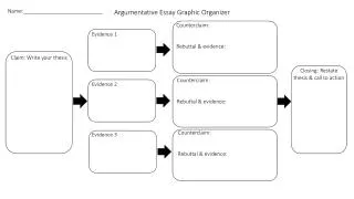
Customizable Graphic Organizer for Virtual Fieldwork. Provided by ReaL Earth System Science http://virtualfieldwork.org / & http://teacherfriendlyguide.org / Adapted from work by Sarah R. Miller. Table of Contents. About This Template Connecting to Big Ideas & Overarching Questions

E N D
Customizable Graphic Organizer for Virtual Fieldwork • Provided by ReaL Earth System Science • http://virtualfieldwork.org/ • & • http://teacherfriendlyguide.org/ • Adapted from work by Sarah R. Miller
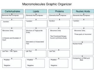
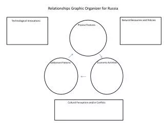
Table of Contents • About This Template • Connecting to Big Ideas & Overarching Questions • Download the Most Recent Version! • One More Thing... • The Template (or click on the image in the lower left) • The effects of water on the landscape • Are there valleys, mountains or hills? • What do you think the climate is like here? Why? • What types of rocks are there? • Do the rocks seem to form a sequence? • What effects have humans had on the landscape? • Suggestions for improvement are welcome! • Suggestions that haven’t been worked in as yet...
About this template... • This is a template for creating one sort of virtual fieldwork experiences (VFEs) of sites that are interesting from an Earth systems science perspective. • It is not intended to be the only sort of VFEs, but rather might be thought of as an “entry level VFE.” The kinds of explorations learners can do in this format are real and valuable but somewhat limited. • For more information about VFEs, and to download the most recent version of this template as a PowerPoint, Keynote or html file, see virtualfieldwork.org. Assessment materials are also available on the site. • The pictures used in the template were taken in the Arbuckle Mountains of Oklahoma in July of 2009. • The questions are intentionally written in such a way that they can be asked about any site.
More about this template... • This is not intended as a presentation, but rather as something for learners to work through individually or in small groups. Teachers may adapt as they see fit, however. • To use this as a template, simply replace the photos from the Arbuckles with photos from your own field site. All the arrows are hyperlinked. Click on them to go to a page with more on the question in the arrow. • Blue boxes are hyperlinks. Links should work in all formats (html, PowerPoint and Keynote). • Some pictures and text box are also linked. Move the cursor around the different slides to find links.
Still more about this template... • The template is a living document. We’re always looking for input to improve it. • Comments in yellow boxes are either seeking feedback on the draft or suggesting ways slides are expected be changed. • Please send suggestions for additions and other improvements, including suggested photos of the Arbuckles, to: • Don Duggan-Haas at: dugganhaas@museumoftheearth.org. Those yellow boxes look like this.
Connect to Big Ideas & Overarching Questions • The next slide offers one (carefully developed) take on what are the most important ideas to understand about Earth. • For more on big ideas and overarching questions, see: http://virtualfieldwork.org/Big_Ideas.html
VFEs Are Question Driven • Ultimately, we want learners to be able to read the landscape: by looking at it’s shape, and the rocks and other materials that compose and move through it, a story can be unearthed. • “Why does this place look the way it does” is the driving question for the project. • Sub-questions vary in size, scale and purpose. Some questions may have a one or two word answer, but those questions should be followed with questions of how we know and what those simple answers imply. • For all of these questions: • How do you know? (What evidence is there?) • What does it tell you about past environments? • What does it imply about the future?
Download the most recent version! • This version was posted June 14, 2010. • If you are viewing the online version, you are looking at the most recent version. • URLs for download: • as html: • http://virtualfieldwork.org/pp/customizableVFEgraphicorganizer.htm • as PowerPoint: • http://virtualfieldwork.org/pp/customizableVFEgraphicorganizer.ppt • As Apple Keynote: • http://virtualfieldwork.org/pp/customizableVFEgraphicorganizer.key
One more thing... • Virtual fieldwork is not a substitute for actual fieldwork! • If you’re a teacher, use the creation of a VFE as a stepping stone toward taking your students (perhaps not this year’s) into the field, and as a way to both prepare for and process the completion of fieldwork. • Consider having your students create VFEs so that they might teach other learners around the country and around the world about your environment.
And now... • onto the actual template!
Are there mountains, valleys, or hills? • What are the valley shapes? • What can form valleys? • What can cause mountains or hills to form? • Are the mountains or hills young or old? • What role do tectonics play in shaping the site? Why does this place look the way it does? What effects has life, including human life, had on the landscape? Describe the shape of the land. • For all of these questions: • How do you know? (What evidence is there?) • What does it tell you about past environments? • What does it imply about the future? What types of rock are there? • How have plants shaped the landscape? • How have animals generally, and humans in particular, changed the landscape? • On what scale? What effects has water had on the landscape? Do the rocks seem to form a sequence? What effect has the climate had on the landscape? • Sediments & Sedimentary Rocks • Is it clastic or organic/chemical? • If clastic, what is the grain size? • If organic, what minerals is it made out of? • Are there fossils? • Is water depositing material, eroding material, or both? • Is the action of water primarily chemical, primarily physical, or both chemical and physical? • Metamorphic • Is it foliated or non-foliated? • What was the parent rock? • Igneous • Did the rock form above or below ground? • Is it felsic or mafic? • Where would you find the oldest rocks? • Youngest rocks? • Are there different kinds of rocks at different outcrops? • Was the past climate different? • What factors may have been affected or caused by climate?
What effects has water had on the landscape? • Is water depositing material, eroding material, or both? • Is the action of water primarily chemical, primarily physical, or both chemical and physical?
What effects has water had on the landscape? Link to a ZoomImage of this photo. It is a high resolution photo that you can zoom in and pan around. Create your own ZoomImage here.
Describe the shape of the land. • What can cause mountains or hills to form? • Are the mountains or hills young or old? • What is the valley’s shape? • What can form valleys? • What is the role of plate tectonics in shaping the land? • Would benefit from: • a picture of those nice folds near the base of the falls. • Embedded links like on rock hammer pictures (in rock type slides ahead). • Add embedded tombstoning pictures. • Are these mountains or hills? How do you know? • Embedding panorama
What do you think the climate is like here? Why? • What factors influence the climate? • Identify features shaped or determined by climate. • Was the past climate different? How can you tell? • How is climate change likely to affect this place? • This would benefit from: • More pics • swiss cheese rock • travertine • Is the overarching question the right one? • Carbon sequestration & GHG world...
What types of rock are there? • A common question for all rock types: • What do the characteristics of the rock tell you about past environments? • In this template, there is at least one page for each general rock type (metamorphic, igneous, and sedimentary) • Many field sites have only one of these three types of rocks. • Sedimentary • Is it clastic or organic/chemical? • If clastic, what is the grain size? • If organic, what minerals is it made out of? • Are there fossils? • What do the rocks indicate about past environments? Chart of common rock textures • Igneous • Did the rock form above or below ground? • Is it felsic or mafic? • Metamorphic • Is it foliated or non-foliated? • What was the parent rock?
Common Rock Textures Chart by Jim Ebert, SUNY Oneonta
What types of rock are there?Sedimentary • Sedimentary • Is it clastic or organic/chemical? • If clastic, what is the grain size? • If organic, what minerals is it made out of? • Are there fossils? • What do rock characteristics tell you about past environments? Scheme for Sedimentary Rock ID
Do the rocks seem to form a sequence? • Where would you find the oldest rocks? • Youngest rocks? • Are there different kinds of rocks at different outcrops? • This would benefit from: • Folded stuff • tombstone • Is there tilting? If so, what does that imply? • What direction was the camera “looking?” The pictures here were taken on opposite sides of the road. The tilting shown is all in the same direction. • Panorama -- looking west • Right -- looking east (double check that) • Link to GE file with all pics • Picture measuring dip and strike
What effects have humans had on the landscape? • This would benefit from: • Another question or two. (I just added the second one and it could stand editing) • A garbage shot. which is more what q2 is about. • Rephrase second bullet. • Note that the curve is a result of the photostitching, not a curve in the road. • unintended consequences... cost/benefit analysis... • "What are the unintentional consequence of the human impact?" • On what scale? • Were the human impacts on the site done intentionally or were they done without thinking about consequences?
Suggestions for improvement are welcome! • There’s ample room for improvement! • Please send suggestions for additions and other improvements, including suggested photos of the Arbuckles, to: • Don Duggan-Haas at: dugganhaas@museumoftheearth.org.
Suggestions that haven’t been worked in as yet... • What would this place look like if ______________ (some process or event) hadn’t happened? • Please send suggestions for additions and other improvements, including suggested photos of the Arbuckles, to: • Don Duggan-Haas at: dugganhaas@museumoftheearth.org.