Download
1 / 17
170 likes | 266 Views
Mapping Emergencies. To inform the ABC’s digital emergencies strategy. To inform future development of location-based services . Why map emergencies? . “Connected communities are resilient communities” – the National Strategy for Disaster Resilience.

E N D
To inform the ABC’s digital emergencies strategy To inform future development of location-based services Why map emergencies? “Connected communities are resilient communities” – the National Strategy for Disaster Resilience. Social media + smart phones are changing the expectations of users during an emergency. Argued that the expectation for instant accurate information by the public remains beyond the capacity of any single authority. Part of a longer term strategy to deliver hyper-local services that build on the unique qualities of the ABC Not confined to emergency coverage – could be news, weather, history, arts, sport
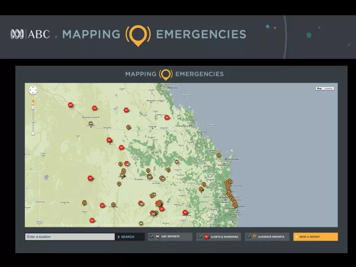
Enable audiences to access a range of reports on an emergency event specific to a location from three main sources: • ABC News • Emergency Service Agencies (ESAs) • Social media Objectives While the unverified nature of much social media reporting is recognised, this doesn’t detract from its perceived utility. “[c]itizens are willing to trade off reliability and accuracy for timeliness and will resort to other information sources such as social media if authorities cannot provide timely information.” Government 2.0 taskforce paper Social Media Helping Emergency Management (Dec 2009),
Technologiestrialled • Trial involved scoping of existing ABC location reporting capabilities • Could not integrate with the ABC’s content management system at present time • Instead used Google Fusion Tables, Twitter and RipeIntel RSS feeds
Send reports Call to action to submit reports via Twitter, Facebook, Flickr, Email, and SMS.
Maps created Emergency maps -NSW floods -Qld floods -Sydney storms -TC Heidi Non-emergency maps -Time person of the year -Tendulkar centuries -Ponting -Road fatalities
Maps created Key Tweets Good information but inadequate geo-location data to be placed on the map. ABC Reports Twitter search API using @Mapemergency Ripe Geo-tweet Official warnings Twitter search API @Mapemergency RTs Using hashtags + Geo-Tweet Social media Fusion tables -Twitter -Facebook -Flickr
List view generated via Mapemergency twitter account Delivered combination of ABC and official warnings
Editorial issues Highly dependent on social media harvesting Lack of location data Timeliness: Real-time or historical data capture? Verification – social media mostly from journos or Emergency Service Organisations Availability of social media dependent on location Resource intensive “Twitter speak” – an issue for the list view
Social media reports • Most gave a general location, but no specific geo-location data. • Lots of images posted on social networks during flood emergencies. • Few included information that could help other community members make decisions in affected areas. • Many came from ABC and other journalists reporting in the affected areas. • More densely populated areas produced the highest volume of tweets.
Other issues • Dealing with historical data and finding ways to remove irrelevant tweets from the maps was an issue – eg, old flood warnings. • Editorial team used the disclaimer “location is approximate” on tweets where a general location could be established. • Users not able to tell what they’ve already viewed when they return to the maps and new items that have been added, sometimes causing confusion.
Gabby Shaw Acting Head Strategic Development ABC Innovation shaw.gabrielle@abc.net.au