Download
1 / 13
130 likes | 272 Views
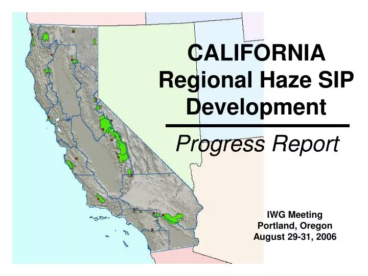
CALIFORNIA Regional Haze SIP Development Progress Report. IWG Meeting Portland, Oregon August 29-31, 2006. HIGHLIGHTS. Federal Land Managers IMPROVE BART Interstate Consultation Interstate Transport Reasonable Progress. FEDERAL LAND MANAGERS. Intra-State Consultation

E N D
CALIFORNIA Regional Haze SIP DevelopmentProgress Report IWG Meeting Portland, OregonAugust 29-31, 2006
HIGHLIGHTS • Federal Land Managers • IMPROVE • BART • Interstate Consultation • Interstate Transport • Reasonable Progress
FEDERAL LAND MANAGERS • Intra-State Consultation • Bi-Annual Meetings • Regional Haze Teach-In
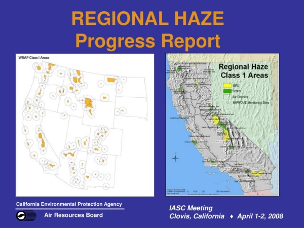
IMPROVE MONITORING • Match Air Basins • Similar Elevations • Reasonable Distance • Future Growth and Land Use • Research Value • Rank Importance
BART-eligible FACILITIES • Possibly 30 facilities outside the SJV and SC • Sixteen BART categories • RACT and rule stringency • Q/D elimination, then Subject-to-BART modeling • Title V permits • TPY reductions minimal
FAR NORTHERN CALIFORNIA concentration extinction • Species Analysis • Haze Drivers • Seasonality • Concentration • Extinction • Geography • Terrain • Meteorology • Regional vs. Local • Proximity to eight Class 1 Areas REDWOODS Coastal Avg. Worst 18.45 dv TRINITY Remote Forest Coast Range (lee) Avg. Worst 16.32 dv LAVA BEDS Inland Plain Avg. Worst 15.05 dv LASSEN VOLCANIC Western Base of Mountain Avg. Worst 14.15 dv
FAR NORTHERN ISSUES • Surrounding Land Use - Natural - Anthropogenic - Transport (Pacific, OR, WA, NV, Asia) • Species Reductions • Nitrates, sulfates, woodsmoke • Long-Term Strategy • Smoke Management • On/Off Road Mobile - BART - SB 656
SOUTHERN CALIFORNIA • Species Analysis • Nitrates, Sulfates, OC, Coarse Mass, EC • Attribution • Mobile Sources primarily; Boundary Transport • Strategies (NAAQS non-attainment) • Diesel Risk Reduction, Goods Movement, BACM
GLIDE PATH BENCHMARKS • Lowest Hurdles • coast at sea level • lee of Sierra • Highest Hurdles • southern Sierra • southernmost C1As • Regional Response to Reductions • Gap Analysis
VISIBILITY IMPROVEMENT • San Gorgonio GAP Analysis • Achieve 70% of 2018 deciview benchmark • 45% reduction in nitrate extinction • 11% reduction in OMC; 37% reduction in EC • slight increase in sulfate, coarse mass, and fine soil extinction • Overall Trend is Improvement
WHO IMPACTS WHOM • Uncontrollable Boundary Sources • BART Sources • Large Nearby Sources • Caveats for Attribution Modeling Results • Relative Percentage for Consultation Phase 1 Report TSSA: Combined Nitrate & Sulfate >50% 25-50% <25%
REASONABLE PROGRESS • Justify Reasonable Progress Goal using WRAP data analyses • Wildfires • Transport • Mobile sources, transportation corridors • Population growth and land use • Nearby stationary source facility • Long Term Strategy • Explaining California SIP Commitments • Don’t shoot the messenger!