Download
1 / 14
140 likes | 257 Views
NRCS Soils Data. National Soil Information System NASIS. NRCS Soil Data. Origins pre-date computers and models data collection spans decades. Not designed or maintained with modeling in mind. Not perfect; need to have a procedure to handle errors and omissions.

E N D
NRCS Soils Data National Soil Information System NASIS
NRCS Soil Data • Origins pre-date computers and models • data collection spans decades. • Not designed or maintained with modeling in mind. • Not perfect; need to have a procedure to handle errors and omissions. • Must be adapted to meet model needs
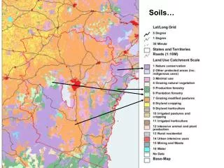
Characterization Data 70+ years Support classification and Soil Taxonomy Support interpretations Point data, measured Horizons NASIS ~20 years, early computer tech Interpret char. data Provides interp. data for broad landuse decisions Mapunit based, not pt. Layers NRCS Soil Databases
NRCS Soil Databases • Both NASIS and Soil Taxonomy are landuse independent. • Characterization data may provide clues. • Use Soil Taxonomy to fill or fix bad records.
NRCS Soil Databases • NASIS reports a Representative Value (RV) and a range, hi and lo. • Use the value that best reflects the landuse being modeled. • The RV works better for empirical models like RUSLE than a process model like EPIC or APEX
Ap Layer 1 AB Bt1 Layer 2 Bt2 2Bt3 Layer 3 2Bt4
Updates for modeling • Established research grade position for modeling support for Soil Survey. • Rapid C project. Collecting soil carbon data at NRI points. • Error and omission checking. • Begin collection of dynamic soil propeprties and data structure for dissemination.