Download
1 / 14
210 likes | 1.01k Views
Ecoregions of Texas. And the effects of weathering,erosion , and deposition. Factors Affecting Our Ecoregions. Weathering – chemical and physical break down of rocks into sediment Erosion – the movement of sediment from one place to another

E N D
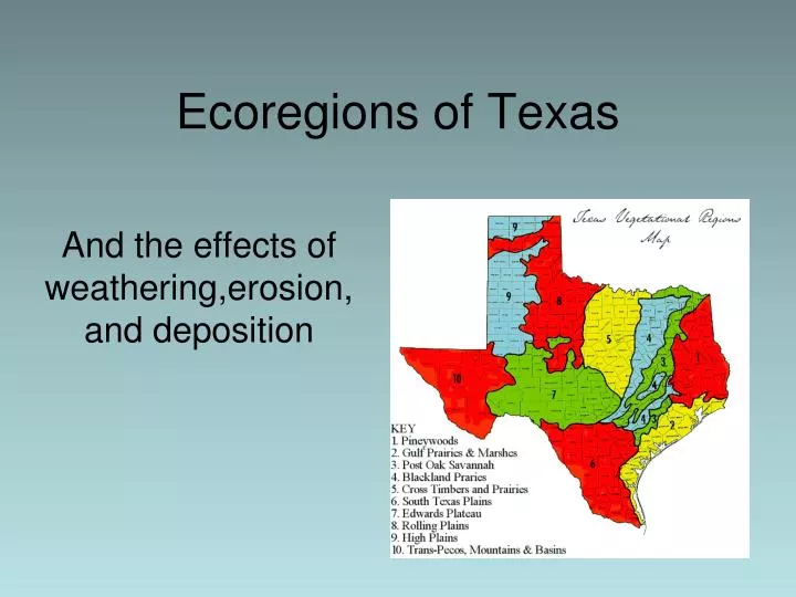
Ecoregions of Texas And the effects of weathering,erosion, and deposition
Factors Affecting Our Ecoregions Weathering– chemical and physical break down of rocks into sediment Erosion – the movement of sediment from one place to another Deposition – the placement of sediment after being carried from place of origin
What is an ecoregion? • A relatively large unit of land or water that is characterized by a distinctive climate, ecological features, and plant and animal communities
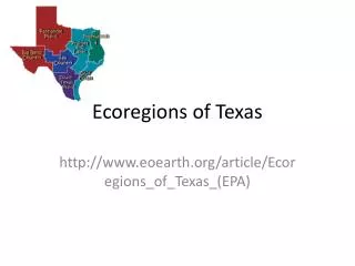
Regions of Texas • 1 – High and Rolling Plains • 2 – Oak Woods and Prairies and Blackland Prairies • 3 – Pineywoods • 4 – Gulf Coast Prairies and Marshes and Coastal Sand Plains • 5 - South Texas Brush Country • 6 –Edward’s Plateau and Llano Uplift • 7 – Trans Pecos
What is the topography of the ecosystems? What effect could that have on erosion and deposition?
What effect do the rock types have on erosion and deposition?
Which ecoregions have the most precipitation? What effect could that have on vegetation? On erosion and deposition?
High and Rolling Plains“The Panhandle” • Mostly flat and grassy • Mostly treeless • On a high, flat plateau • The eastern portion is not as flat and is brushy • Includes deep canyons carved by rivers • Average regional rainfall 15-28 inches a year
Oak Woods & Prairies and Blackland Prairies • Transition between plains of the Panhandle and the Pineywoods of East Texas • Patches of woodland sprinkled throughout a grassland prairie • Gently rolling to hilly • Rich, fertile and black soil • Average regional rainfall – 26-40 inches per year
Pineywoods“East Texas” • Primarily thick pine forest • Larger forest extents into Louisiana, Arkansas, and Oklahoma • Rolling terrain with wet bottomlands • Swamps are common especially in the “Big Thicket” • Average regional rainfall 40-52 inches per year
Gulf Coast Prairies and Marshes and Coastal Sand Plains • Bays, marshes, and barrier islands • Estuaries (salt and fresh water meet) • Prairies and grasslands as you travel west • Houston is a part of this ecoregion • Average regional rainfall 40-60 inches per year • Can have extensive flooding from storms and hurricanes
South Texas Brush Country • Runs from edges of the Hill Country to the Lower Rio Grande Valley • Mostly dry and covered with grasses and thorny brush such as mesquite and prickly pear cacti • Average regional rainfall 20-32 inches per year
Edward’s Plateau and Llano Uplift“The Hill Country” • High flat land (plateau) eroded into hilly terrain • Many springs and steep canyons • Underground lakes in the Edward’s Aquifer area • Caves • Average regional rainfall 15-34 inches per year
Trans Pecos“West Texas” • Region of extremes • Hot dry desert that is cool at night • Mountains – occasionally snows in winter • Forests grow on slopes • Rio Grande River runs through forming a border between Texas and Mexico • Average regional rainfall 8-20 inches per year