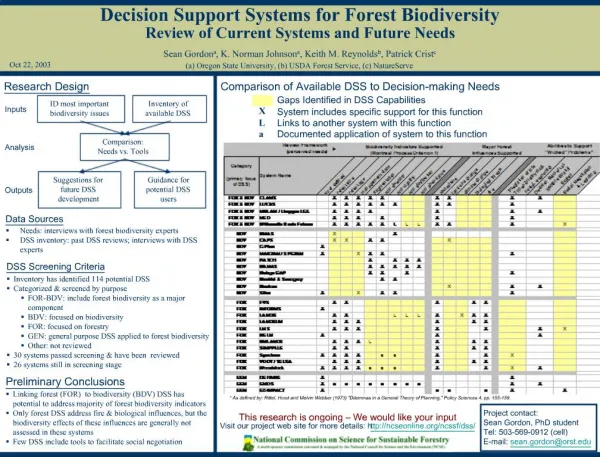
Download
1 / 23
250 likes | 402 Views
NEED for decision support systems for disaster risk management. 19 September 2012. GIS Asia . Hanoi. Kapil Chaudhery kapil@spatialdecisions.com. Spatial Decisions VIETNAM: 68c Tran Quang Dieu , Dong Da , Hanoi INDIA: B30 Kailash Colony, New Delhi. Introduction.

E N D
NEED for decision support systems for disaster risk management 19 September 2012. GIS Asia . Hanoi Kapil Chaudhery kapil@spatialdecisions.com Spatial Decisions VIETNAM: 68c Tran Quang Dieu, Dong Da , Hanoi INDIA: B30 Kailash Colony, New Delhi
Introduction • The number of natural disasters are increasing over the last three decades. • Many of the developing countries of the Asia and the Pacific are situated in the world’s hazard belts and are subject to floods, droughts, cyclones, earthquakes, windstorms, tidal waves and land slides. • Vulnerability to disasters has increased due to the increased aggregation of people in urban centers and a lack of planning and preparedness. Floods are the most common climate-related disaster in this region and include seasonal floods, flash floods, urban floods floods associated with tidal events induced by typhoons in coastal areas. No. of flood events reported (world wide) source: www.emdat.be
Introduction Oct 7, 2007 Sept 30, 2007 Source: http://earthobsevatory.nasa.gov flood Flooding in the Thach Thinh distract of Vietnam October 6, 2007 (source: Reuters photos)
Background • Vietnam is located in the tropical monsoon area. • Frequent tropical cyclones are prevalent mostly in the northern and central part of the country and cause flood and inundation. • The low coastal topography of this region is the reason of its exposure to the high wind and storm surges during cyclone. • Sometimes the cyclones generate from the northwest pacific, travel through the Philippines and enters the Indochinese mainland through Vietnam. • Annually, on an average, 8 cyclones or typhoons strike the Vietnam coast; most of them occurring during July to October. • Vietnam is characterized by very high annual rainfall (1800 -2500mm). 70% - 80% of the annual rainfall occurs during the 3-6 months period of rainy season. Intense rainfall causes rapid rate of run off and consequently flooding. • Heavy rainfall and discharge from the upper Mekong river region causes flood in the Mekong delta region in the southern Vietnam
Background Vietnam is highly vulnerable in terms of hydrological disasters And There is a urgent need of efficient integrated disaster risk management system for Information Communication and DSS
Plan Decision& Action Model Analyze Measure RS/GIS Remote Sensing (RS) & Geographical Information system (GIS): A geographic approach to understand and manage our earth • Efficient • Cost effective • Better understanding • For better • Communication • Collaboration • Decision Making
Integrated Emergency Planning Editor segment Admin segment User segment LocalAuthority (Coordination, communication and management) The web People (Accessing information about the event) FieldSurveyor (Collects relevant data at regular interval) (Service creation and modification and control the visibility of the web) Geo-SpatialExperts (study, analyze and predict flood risk)
EditorSegment PHASE - I 1. Data capture and geo-processing. 2. Ancillary data collection. 3. Image cataloguing and Image analysis. 4. Basic map generation. 5. Robust ancillary data entry in a pre-designed DBMS. PHASE - III Report generation tool The editor captures, creates and edits the raw data and presents them into suitable information for the users. PHASE - II 1. Tools for Early warning and forecasting: Flood trend map, short period flood warning & real time water level. 2. Tools for Flood risk map. 3. Tools for Rehabilitation location map 4. Tools for Important infrastructure map.
Phase – I Non -Spatial Data Spatial Data Satellite sensor Data. GIS Demography Topography Meteorology Land use Other Tabular Data Hydrology Infrastructure Transportation Soil
Phase – II Tool for early warning & forecasting A A B B A A B B 1. Analyze the historic satellite sensor data of past flood events in different years. 2. Map the flooded areas for different years. 3. Then it is possible to identify the areas under flood threat and need more attention in flood management. 4. Also the database can be updated accordingly. Tool for early warning & forecasting
User Segment Service: Flood trend map The map shows the extent to which different areas are prone to flood from overflowing rivers and exceptionally high seas.
User Segment Day: 3 Day: 1 Day: 5 Day: 7 Medium risk High risk Low risk Service: Short period Flood Warning (During flooding)
User Segment Location ------------- Ha Noi Lao Cai etc River level selection Map source: www.wikipedia.org Service: River & Sea levels Enter the location or click on the map
User Segment Service: River & Sea levels Water level at Hoa Binh Highest recorded Water level height Water level height Flooding possible Normal range Current level Time
Phase – II Flood Hazard Critical Hydraulic condition + Area Vulnerability Chance of being exposed to flood + People Vulnerability Ability to respond to flood X Number of people at risk = Flood Risks to people Tools for Flood risk map Flood Risk Flood Hazard - Depth of flooding - Velocity of flood water - Debris factor Area Vulnerability - Speed of onset - Nature of the area - Flood warning People Vulnerability - Distance from river/ coast - Age group
User Segment Select ------------- Flooding from river Flooding from sea Flooding from cyclone Flood maps and flood warning areas derived form previous flood events categorized according to the causes of flood. Maps depicting different flood risk zones. Enter the location or click on the map Province ------------- Thanh Hoa Lao Cai … Select ------------- Flood map Flood risk map Select year ------------- 2010 2009 2008
User Segment Query based indicative river and coastal flood maps Flood maps: Am I at risk of flood? In further detail the flood related maps can be meshed up with the existing detailed base maps available as OGC compliant services.
User Segment Flood Risk Map 1. Calculate flood hazard can be mathematically using existing models. 2. Find and categorize exposure and vulnerability from demographic information and information about essential infrastructures. 3. Categorize the extent and severity of damage from the amount of loss of life and property. All together defines the risk of flood of a particular area.
User Segment Rehabilitation centers Flooded/ flood warning area Rehabilitation Map On the basis of flood maps the locations for the rehabilitation centers can be mapped, where people can shift their settlement during the flood. Those are the area with comparatively higher elevation and less prone to flooding. Location ------------- Can Tho Lao Cai etc
User Segment Source: http://www.sandia.gov Map of Mobile area electric power infrastructure at risk due to hypothetical hurricane scenario Important infrastructure map It is possible to identify which areas of prime importance are at risk of flooding.
Phase - III Report generation On the basis of the collected ancillary data and the data generated during the analysis of the event it is possible to generate report on different aspects of the event such as losses of life and property. Sample of database: account of the loss of property due to flooding
Way forward Sustained Training and capacity building. Collaborative work environment ( more public private partnership). NSDI will be great. Data distribution is a challenge but information distribution should not stop. Community Based Disaster Risk Reduction.
THANK YOU FOR YOUR ATTENTION! Kapil Chaudhery kapil@spatialdecisions.com Spatial Decisions www.spatialdecisions.com INDIA: B-30 KAILASH COLONY, NEW DELHI 110048. TEL: 91-11-41634914 FAX: 91-11-29237246 VIETNAM: 68C TRAN QUANG DIEU STREET, DONG DA DISTRICT, HANOI . TEL/ FAX: 84-4-35378404