Download
1 / 4
40 likes | 184 Views
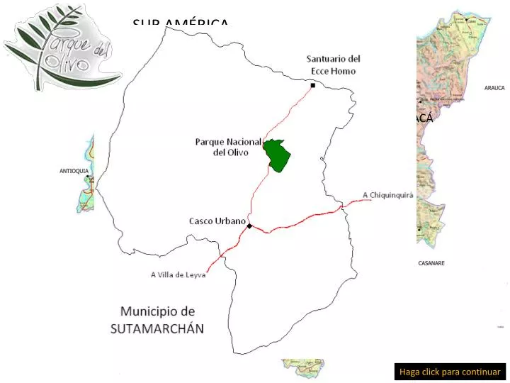
SUR AMÉRICA. REPÚBLICA DE COLOMBIA. DEPARTAMENTO DE BOYACÁ. LOCALIZACIÓN. Municipio de Sutamarchán. Haga click para continuar. Quebrada Rivera. 2.358 m.s.n.m. Extensión: 108,6 Hectáreas. Altura: 2.222 a 2.358 metros sobre el nivel del mar. Lagos Artificiales. Carretera.

E N D
SUR AMÉRICA REPÚBLICA DE COLOMBIA DEPARTAMENTO DE BOYACÁ LOCALIZACIÓN Municipio de Sutamarchán Haga click para continuar
Quebrada Rivera 2.358 m.s.n.m Extensión: 108,6 Hectáreas Altura: 2.222 a 2.358 metros sobre el nivel del mar Lagos Artificiales Carretera Construcción existente Haga click para continuar Quebrada Burriquito 2.222 m.s.n.m
Vista desde la vía Sutamarchán – Villa de Leyva Altura: 2.222 a 2.358 metros sobre el nivel del mar Extensión: 108,6 Hectáreas 2.358 m.s.n.m Construcción existente 2.222 m.s.n.m Haga click para continuar
Panorámicas hacia el Valle de Sutamarchán Haga click para continuar