Download
1 / 27
310 likes | 636 Views
Regions Of Texas!. Four Natural Regions of Texas. Mountains and Basins. This region is the furthest West in Texas . . Physical Characteristics: Mountains Basins Deserts Few Small Rivers Permian Basin. Mountains and Basins. Mountains and Basins. Vegetation (what grows there)

E N D
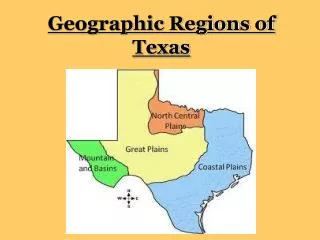
Regions Of Texas! Four Natural Regions of Texas
Mountains and Basins This region is the furthest West in Texas.
Physical Characteristics: • Mountains • Basins • Deserts • Few Small Rivers • Permian Basin Mountains and Basins
Mountains and Basins • Vegetation (what grows there) • Short grasses • Smaller trees and shrubs
Mountains and Basins • Climate • Hot and Dry all year long in the desert • <‘8 inches of rain a year • Tops of mountains see more rain • Drought Climate
Mountains and Basins • Human Geography • Cities (El Paso and Fort Davis) • Oil Fields
Mountains and Basins • Industry (what do you do out there?) • Ranching, Oil, Tourism
Great Plains This Region is East of the Mountains and Basins and is also known as the ‘High Plains’.
Great Plains • PhysicalCharacteristics • Canyons • Plateaus • Plains • Flowing Rivers
Great Plains • Vegetation • Some trees • Grasslands • Flowers
Great Plains • Climate • Hot and Dry seasons • ‘16-’20 inches of rain a year • Cold Winters • Dust Storms are common
Great Plains • Human Characteristics • Cities (Lubbock, Amarillo, Midland, Odessa) • Call it the ‘Panhandle’
Great Plains • Industry • Ranching • Farming • Oil and Gas production • Energy Farms (wind propelled)
Central Plains The Central Plains are located in North Central Texas.
Central Plains • Physical Characteristics: -Rolling Prairies with Fertile Soil -Limestone -Rivers -Hill Country
Central Plains • Vegetation: -Larger Trees -Lush Tall Grasses
Central Plains • Climate -20 to 30 inches of rain per year! (Helps those trees Grow!!) -Rain -Tornadoes
Central Plains • Human Characteristics -Cities (Fort Worth, Abilene, San Angelo) -Large Interstates Systems
Central Plains • Industry -Agriculture and Ranching -Rock and Mineral Quarries -Oil and Gas
Physical Characteristics -Largest Region -Thick Woods -Very Tall Trees and Grasses -Lakes and Rivers *Low Elevation* Gulf Coastal Plains
Gulf Coastal Plains • Vegetation -Varies greatly because most plants thrive
Gulf Coastal Plains • Climate -30 to 55 inches of rain per year -Noticeable Seasons
Gulf Coastal Plains • Human Characteristics -Largest Cities (Houston, Dallas, Austin, Brownsville) -Very Large Populations
Gulf Coastal Plains • Industry -Agriculture -Timber -Shipping -Military -Oil and gas Technology
DID YOU KNOW? The Gulf Coastal Plains and the Central plains are almost exactly divided by I-35. When traveling to Austin from Round Rock on the left are Gulf Coastal Plains, and on the Right are Central Plains.
Homework! Divide page A4 into four sections (look at mine). Each section will be labeled with the regions. Color each section to look like a topographical map that resembles the region. Make sure you include -Physical Features -Water Elements (river, rain, lakes) -Trees and Grasses