Download
1 / 14
140 likes | 362 Views
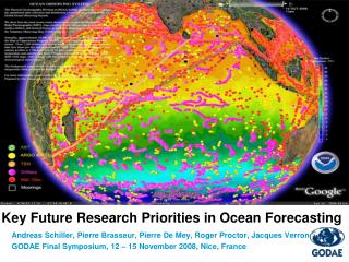
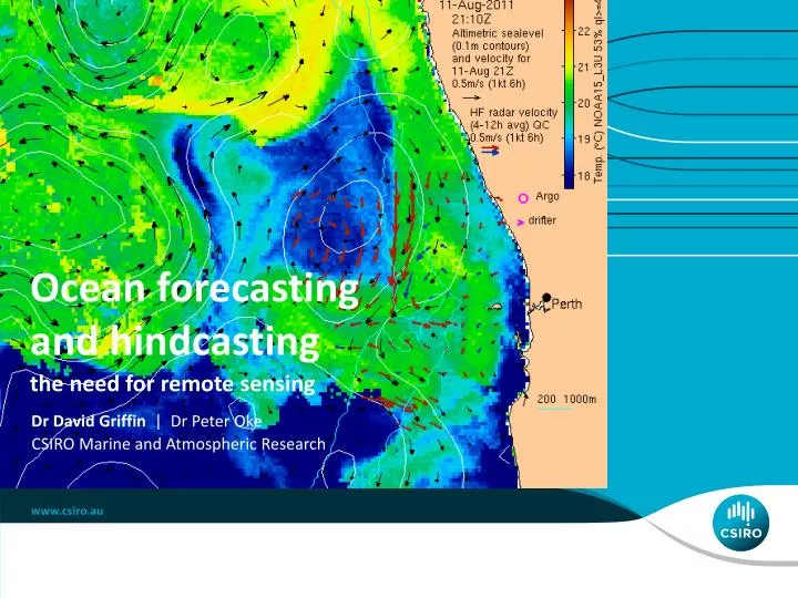
Ocean forecasting and hindcasting. the need for remote sensing. Dr David Griffin | Dr Peter Oke . CSIRO Marine and Atmospheric Research . Forecasting currents is like weather forecasting. The ‘butterfly effect’ is very real. Ocean currents are chaotic.

E N D
Ocean forecasting and hindcasting the need for remote sensing Dr David Griffin | Dr Peter Oke CSIRO Marine and Atmospheric Research
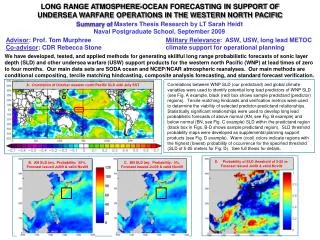
Forecasting currents is like weather forecasting The ‘butterfly effect’ is very real. Ocean currents are chaotic. Ocean models, like weather models, diverge from the truth unless they are constrained by data. The intrinsic length scale of the deep ocean ‘weather’ (eddies etc) is smaller than the atmosphere’s, but the timescale is longer. Surface currents are the sum of these fine-structured chaotic dynamics and shorter timescale, larger length-scale, more deterministic, wind-driven velocities. Let’s look at a year of (modelled) currents in the Great Australian Bight and Northwest Shelf, at the surface and below: David Griffin
Are those eddies realistic, i.e., at the right places? Statistically, yes. Day by day, no. Let’s look at some satellite data for near Perth, last winter and this David Griffin
Merging the two: data assimilation Weather and ocean forecasts are the result of ‘data assimilation’: the process of optimally constraining a model using a relatively sparse set of observations. Satellites and robotic probes (eg Argo) provide global coverage at coarse resolution, for some quantities. Inadequate for shelf dynamics. Regions of particular importance must be instrumented (HF radars, moorings, gliders, etc) if accurate nowcasts are required. Accurate ocean forecasts require 4 things: model, forcing, constraining data, DA system. The last is the hard one, and is a another whole talk. David Griffin
Conclusions Satellite data are one of the essential ingredients of an ocean forecasting system, especially (surprisingly) if you want to know about currents at depth, and/or off-shelf. This contrasts with shelf currents, or surface drift, which can be modelled with some success using wind-driven models. At CSIRO we have developed a system of nested, data-assimilating models that rely on ESA, NASA, CNES, NOAA (and soon ISRO) data. Model accuracy is improving but is still less than users require. Satellites are too few. So CryoSat-2, (a cryosphere research mission) is used for ‘operational’ oceanography. We are very grateful to ESA for making that possible, and look forward to the Sentinels. David Griffin
Thank you David Griffin & Peter Oke +61 3 6232 5244 David.Griffin@csiro.au www.marine.csiro.au/~griffin oceancurrent.imos.org.au CSIRO Marine and Atmospheric Research