Download
1 / 25
270 likes | 482 Views
Introduction to Crowdsourcing & Web Mapping. Agenda. Citizen Mapping OpenStreetMap Google Map Maker Google Earth. Crowdsourcing.

E N D
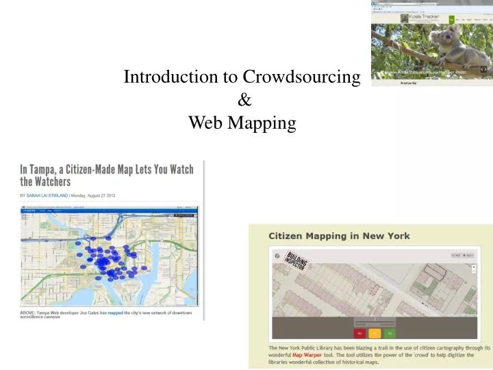
Introduction to Crowdsourcing & Web Mapping
Agenda • Citizen Mapping • OpenStreetMap • Google Map Maker • Google Earth
Crowdsourcing Crowdsourcing is the process of getting work, usually online, from a crowd of people. The word is a combination of the words 'crowd' and 'outsourcing'. The idea is to take work and outsource it to a crowd of workers. Famous Example: Wikipedia. Crowdsourcing & Quality: The principle of crowdsourcing is that more heads are better than one. By canvassing a large crowd of people for ideas, skills, or participation, the quality of content and idea generation will be superior. http://dailycrowdsource.com/
Crowdsourcing is simply asking somebody to do something! You have contributed to crowdsourcing, if you have: - answered a question - made a correction or submission - told a story - answered a survey - voted, tagged, commented Crowdsourcing using maps is also commonly known as Citizen Mapping
OpenStreetMap • https://medium.com/medium-for-haiti/f4582ed41656 www.openstreetmap.org
San Francisco Park Alliance To increase awareness and use of parks and recreation
Google Map Maker http://www.google.ca/mapmaker
Google Earth • Source for information on land and people • Archaeological information • Social and cultural information • Urban and commercial development • Geographical information • Natural disasters and restoration • Earthquake tracking and projections • Mapping! Simple and advanced • Georeferencing photos and maps – higher resolution or historical • 3-D Model building – (infrastructure planning) • Virtual biographies • Navigation and quickest routes
Google Earth and Planning • Using imagery to evaluate city grid and street planning • Urban development over time • uWaterloo development over time
From his office chair in Perth, Professor Kennedy has remotely identified thousands of archaeological sites without having to step foot on Saudi Arabian or Yemeni soil. Historically it has been difficult to undertake ground surveys and aerial photographs of these areas are seldom available for research, making the countries some of the least explored archaeologically. • By carefully studying satellite imagery of the Arabian peninsula in Google Earth, Professor Kennedy has unearthed an enormous record of archaeological sites, from ancient geoglyphs to stone Wheels to Pendant-shaped tombs and animal traps called kites that could be up to 9,000 years old.
http://readwrite.com/2010/04/08/scientist_uses_google_earth_to_find_ancient_ancesthttp://readwrite.com/2010/04/08/scientist_uses_google_earth_to_find_ancient_ancest
Discussion Forum • Discover some citizen mapping projects that you are interested in OR • Contribute your local knowledge to Google Map Maker • Share with the class online
Google Earth Assignment Please complete the tutorial and then create a map in Google Earth with the following components: • A title • A written introduction to your project • At least five placemarks, embedded with html tags, and images, if possible. • Imported KML file(s) • A screen overlay (i.e. a legend)