Download
1 / 19
190 likes | 333 Views
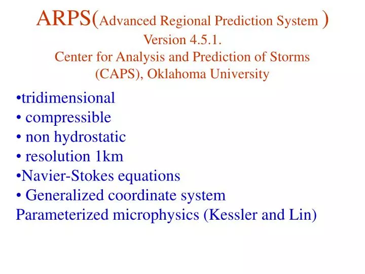
ARPS( Advanced Regional Prediction System ) Version 4.5.1. Center for Analysis and Prediction of Storms (CAPS), Oklahoma University. tridimensional compressible non hydrostatic resolution 1km Navier-Stokes equations Generalized coordinate system

E N D
ARPS(Advanced Regional Prediction System)Version 4.5.1.Center for Analysis and Prediction of Storms (CAPS), Oklahoma University • tridimensional • compressible • non hydrostatic • resolution 1km • Navier-Stokes equations • Generalized coordinate system • Parameterized microphysics (Kessler and Lin)
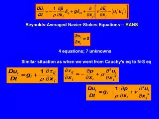
Main Equations • Prognostic equations for u, v, w,, p’ and • Where: : water vapor, cloud water , rain water, cloud ice, snow and hail (graupel) • Equation of state
Conservation equations for mixing ratios (vapor qv, cloud water qc , rain water qr, cloud ice qi, snow qs and hail qh.) advection Sources (microphysical processes) sedimentation mixing
July 2, 2001 Severe storm General simulation parameters. • Domain: 90x96x20 km • Horizontal Resolution : 1 km • Vertical Resolution : 0.5 km • Time Resolution: 6 s • Lateral Boundary Conditions: Open (Klemp and Wilhemson, 1978) • Top and Bottom B.C. Zero normal gradient • Considered: • Orography, Radiative effects, Land Use, Coriolis.
Convection initiated with an ellipsoidal perturbation Θmax= 4K Central coordinates: x=50 km, y=37 km, z=1.5 km Dimensions: 10x30x1.5 km (Simulating the form and dimensions of a preexisting storm) • Control output : every 60 s • Total simulation time: 3 h
Environment: • Radiosounding 13:00 LST • Camagüey, Cuba (21°25' N , 77°10' W)
Domain: Camagüey, Cuba (A 90 x 90 km square, with lower-left vertix at 21°25' N , 77°10' W)
Domain: Camagüey, Cuba (A 90 x 90 km square, with lower-left vertix at 21°25' N , 77°10' W)
Vertical Vorticity (x 10-5 s-1), z = 6 km t = 30 min., t = 50 min., t = 70 min w(m/s) Vertical Vorticity, z = 9 km
Reflectivity (dBZ)n and w (m/s) t=50 min, z=9 km t=70 min., z=9 km 48 32 W(m/s) 48 60
qi and qH (g/kg)for for theWmax. slice in the Y-Z plane qc and qR (g/kg)for the Wmax. slicein the Y-Z plane
qc and qR (g/kg)for theWmax. slicein theY-Z plane qi and qH (g/kg)for theWmax. slicein theY-Z plane
Left moving cell Left moving cell Center of the system Center of the system Right moving cell Right moving cell Trajectories of the centers of both cells and the center of the system. Point labels indicate simulation time.
CAPPI 3-4 km
CAPPI 9-10 km
CONCLUSIONS • Low precipitations supercell system, generated in an environment of high instability, and clockwise turning hodograph with low wind speeds at the lower levels and strong, and nearly unidirectional wind shear at heights from 6 to 12 km. • Split storm structure, more clear at upper levels • Left moving cell disspated by the entrainment of cold air, generated in the central downdraft at low and middle levels, conditioned by the wind profile.