Download
1 / 36
410 likes | 988 Views
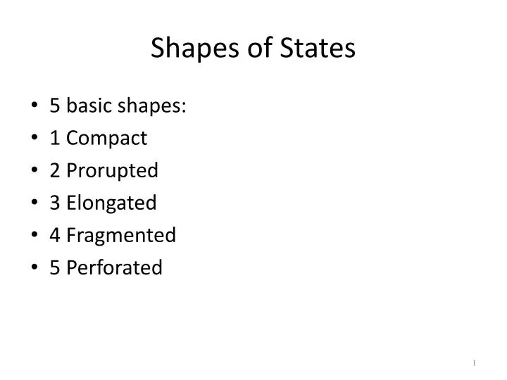
Shapes of States. 5 basic shapes: 1 Compact 2 Prorupted 3 Elongated 4 Fragmented 5 Perforated. 1. Compact States: Efficient. In a compact state, the distance from the center to any boundary does not vary significantly.

E N D
Shapes of States • 5 basic shapes: • 1 Compact • 2 Prorupted • 3 Elongated • 4 Fragmented • 5 Perforated
1. Compact States: Efficient • In a compact state, the distance from the center to any boundary does not vary significantly. • The ideal theoretical compact state would be shaped like a circle, with the capital at the center and the shortest possible boundaries to defend. • Examples: Burundi, Kenya, Rwanda, and Uganda
2. Prorupted States: Access or Disruption • An otherwise compact state with a large projecting extension is a prorupted state. • Proruptions are created for 2 reasons: • Access to a resource such as water • They can also separate two states that otherwise would share a boundary. When the British ruled the otherwise compact state of Afghanistan, they created a long, narrow proruption to the east that was to prevent Russia from sharing a border with Pakistan.
Elongated States: Potential Isolation • There are a handful of elongated states, or states with a long and narrow shaped. • The best example is Chile. • Chile is wedged between the Pacific Coast and the Andes Mountains. • Other examples are Italy, Gambia, Malawi • Elongated states may suffer from poor internal communications.
Fragmented States: Problematic • A fragmented state includes several discontinuous pieces of territory. • 2 kinds: those areas separated by water, and those separated by an intervening state. • The most extreme example is Indonesia, made up of 13,677 islands. • The fragmentation hinders communications makes integration of of people living on remote islands nearly impossible.
Fragmented States • A difficult type of fragmentation occurs if the 2 pieces of territory are separated by another state. • Imagine the difficulty of communicating between Alaska and the lower 48 if Canada were not a friendly neighbor. • The division of Angola into two pieces by Congo’s proruption creates a fragmented state. • Russia is fragmented by other independent states. Kalingrad is along the Baltic Sea.
Fragmented States • An unusual case of fragmentation is in India on a tiny strip of land called Tin Bigha. • The Tin Bigha corridor measures only 600 feet by 300 feet. • It fragments Dhagram and Angarpota from the rest of Bangladesh. • The problem is a legacy of the British who divided the region according to religion with Hindu enclaves to India and Muslim enclaves to Bangladesh. • India agreed to lease the Tin Bigha corridor to Bangladesh. • This created another fragmentation - Cooch Behar from the rest of India.
Perforated States: South Africa • A state that completely surrounds another is a perforated state. • The one good example is South Africa which completely surrounds the state of Lesotho. • Lesotho must depend entirely on South Africa for the import and export of goods.
Landlocked States • A landlocked state lacks a direct outlet to the sea because it is completely surrounded by several other countries. • They are the most common in Africa, where 14 of the 54 states have no ocean access. • To send and receive goods by sea a landlocked state must arrange to use another country’s seaport. • Zimbabwe ships more than half of its freight through the South African seaport of Durban.
Types of Boundaries • Frontiers used to separate states. A frontier is a zone where no state exercises complete political control. • A frontier is a geographic area, whereas a boundary is a thin, invisible, imaginary line. • Frontiers between states have been replaced by boundaries. • Boundaries are of two types: physical and cultural
Physical Boundaries • Important physical features on Earth’s surface can make good boundaries because they are easily seen. • 3 types of elements serve as boundaries between states--mountains, desert, and water.
Mountain Boundaries • Mountains can be effective boundaries if they are difficult to cross. • They also lend themselves well because they are rather permanent and sparsely populated.
Desert Boundaries • A boundary drawn in a desert can also effectively divide two states. • Deserts are hard to cross and sparsely populated. • Desert boundaries are common in Africa and Asia.
Water Boundaries • Rivers, lakes, and oceans are the physical features most commonly used as boundaries. • Boundaries are typically in the middle of the water. • Water boundaries offer good protection in that the invading state must transport troops and secure a landing spot. • Use of water as boundaries can cause difficulties. • Rivers change their course. • The law of the Sea, signed by 117 countries in 1983, standardized the territorial limits for most countries at 12 nautical miles (14 miles).
Cultural Boundaries • The boundaries between some states coincide with differences in ethnicity, especially language and religion. • Other cultural boundaries are drawn according to geometry; they are straight lines drawn on a map.
Geometric Boundaries • Part of the northern US boundary with Canada is a 1,3000 mile straight line along 49 degrees north latitude. • The 600 mile boundary between Chad and Libya is a straight line drawn across the desert in 1899 by the French and British to set the northern limit of French colonies in Africa.
Religious Boundaries • Religious differences often coincide with boundaries between states. • Only in a few cases has religion been used to select the actual boundary line. • When the British partitioned India into two states the Muslims were allocated to Pakistan and the Hindus to India. • In Ireland - most of Ireland is Roman Catholic whereas Northern Ireland is mostly Protestant.
Language Boundaries • Language is an important cultural characteristic for drawing boundaries, especially in Europe. • After WW1 leaders of the victorious countries met at Versailles to redraw the map of Europe. • The conference was concerned with Eastern and Southern Europe - long troubled by political instability. • Boundaries were drawn around the states of Eastern Europe with regard to language. • Speakers of several South Slavic languages were placed together in the new country of Yugoslavia.
Language Boundaries • Czechoslovakia was created by combining the speaker of Czech and Slovak. • The countries were relatively stable until the 1990’s when the boundaries of Czechoslovakia and Yugoslavia collapsed.
Electoral Geography • The boundaries separating legislative districts within the US are redrawn periodically to make sure that each district has approximately the same population. • Boundaries have to be redrawn because migration results in some districts gaining population, and others losing. • The districts of the 435 US House of Rep are redrawn every 10 years following the census. • The job of redrawing boundaries is entrusted to the state legislature.
Electoral Geography • The political party in control of the state legislature naturally attempts to redraw boundaries to improve the chances of its supporters to win seats. • The process of redrawing legislative boundaries for the purpose of benefiting the party in power is called gerrymandering. • The term was named for Elbridge Gerry, governor of Massachusetts (1810-12). • As governor Gerry signed a bill that redistricted the state to benefit his party. An opponent observed that the oddly shaped new district looked like a salamander - another opponent said that it was a “gerrymander.” A newspaper then printed a cartoon of a monster named “gerrymander” with a body shaped like the district. The term has remained with us.
Types of Gerrymandering • Gerrymandering takes 3 forms: • “Wasted vote” • “Excess vote” • “Stacked vote”
Wasted vote spreads opposition supporters across many districts but in the minority. • Excess vote concentrates opposition supporters into a few districts. • Stacked vote links distant areas of like-minded voters through oddly shaped boundaries.
Gerrymandering works like this: suppose a state has 2.5 million voters to be allocated among five Congressional districts of 500,000 voters each. • Party A has 1.3 million supporters, or 52% of the state total. • Party B has 1.2 million or 48%
If Party A controls the redistricting process it could do a “wasted vote” gerrymander by putting in each of the five districts 260,000 of its voters and 240,000 of Party B voters, thereby giving Party A the opportunity to win all five districts despite holding a statewide edge of only 52-48%.
If Party B controls the redistricting process it could do an “excess vote” gerrymander by putting 260,000 of its voters and 240,000 of Party A voters in four of the five districts and concentrating 340,000 Party A voters and only 160,000 Party B voters in the fifth district, thereby giving Party B the likelihood of winning four of five districts.
“Stacked Vote” Gerrymandering • Most of the recent gerrymandering in the US has been primarily “stacked vote.” • If Party A in the previous example controls the redistricting process, the trend has been for legislatures to create three districts each with 300,000 of its voters and 200,000 of Party B’s voters and 2 districts both with 200,000 of its voters and 300,000 of Party A voters. That way, all 5 districts are in possession of one party.
Pink= Republicans Green= Democrats Who will win the 2nd election?
The US Supreme Court ruled gerrymandering illegal in 1985 but did not require dismantling of existing oddly shaped districts.