Download
1 / 41
420 likes | 724 Views
The United States Spatial Terms Comparing Two Regions of United States. Unit 2 Lesson 6. Content Expectations 4 - G2.0.1: Describe ways in which the United States can be divided into different regions (e.g., political regions, economic regions, landform regions, vegetation regions).

E N D
The United States Spatial TermsComparing Two Regions of United States Unit 2 Lesson 6
Content Expectations 4 - G2.0.1: Describe ways in which the United States can be divided into different regions (e.g., political regions, economic regions, landform regions, vegetation regions). 4 - G2.0.2: Compare human and physical characteristics of a region to which Michigan belongs (e.g., Great Lakes, Midwest) with those of another region in the United States.
Graphic Organizer Location Climate Landforms Vegetation Physical Characteristics Bodies of Water Natural Resources Comparing Regions Human Characteristics Cities Population Transportation Networks Economic Activities
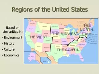
A region is an area with at least one geographic feature, or characteristic, which sets it apart from other areas. List various U.S. regions to which Michigan belongs. Possible regions include the Middle West region, the Great Lakes region, and the Rust Belt.
In this lesson students will be learning more about the Great Lakes Region. Then students will research another U.S. region with a partner.
Word Cards from previous lessons needed for this lesson: • Location – Word Card #2 from Lesson 1 • Physical Characteristics – Word Card #2 from Lesson 2 • Human Characteristics – Word Card #1 from Lesson 3 • Transportation Network – Word Card #2 from Lesson 3 • Climate – Word Card # 3 from Lesson 4 • Population – Word Card #6 from Lesson 4 • Region – Word Card #1 from Lesson 5
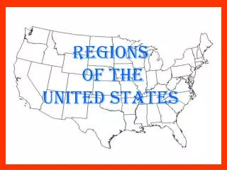
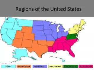
The Great Lakes Region Overhead #1 Identify the states and Canadian provinces that make up the region.
The Great Lakes Region Overhead #1 The darker area around the Great Lakes depicts the Great Lakes Drainage Basin.
The Great Lakes Region Overhead #1 • The Great Lakes hold one-fifth of the world’s surface fresh water. • The Great Lakes support a multi-billion dollar tourist and fishing industry. • The Great Lakes region is the center of North America’s industrial and agricultural heartland. • Two countries, two Canadian provinces, eight American states, and hundreds of cities are part of the Great Lakes ecosystem. • Source: The Great Lakes. Great Lakes Information Network. 8 October 2008 <http://www.great-lakes.net/lakes/>.
If you spread the water in the Great Lakes evenly across the continental U.S. the water would be about 9.5 feet deep. • The Great Lakes basin is home to some 40 million Canadians and Americans. • The Great Lakes and islands within them have more than 10,000 miles of coastline. • Since early times, the Great Lakes have supported life and provided drinking water, transportation, power, and recreation. • Source: The Great Lakes. Great Lakes Information Network. 8 October 2008 <http://www.great-lakes.net/lakes/>.
The Great Lakes Region Overhead #1 What else do you remember about the Great Lakes from Grade 3 and their study of Michigan geography? The Great Lakes are the geographic characteristic or feature that sets this region apart from other U.S. regions.
The Great Lakes Region Overhead #1 The lakes have influenced the history, climate, economic activities, transportation, and culture of the places that make up this region.
Great Lakes Information Sheets Lake Erie Lake Erie is the smallest of the Great Lakes. It measures 241 miles across and 57 miles from north to south. It has about 871 miles of shoreline. Lake Erie is the shallowest of the Great Lakes. Its average depth is only about 62 feet. At its deepest spot, it is only 210 feet. It warms quickly in spring and summer and often freezes over in winter. It is surrounded by land with very fertile soil so there are lots of farms. It also has a lot of industry near it and 13 busy ports. Lake Erie has been exposed to more stress than any other Great Lake. This has been caused by people, industry, and farming.
Lake Huron Lake Huron measures about 206 miles across and 183 miles from north to south. It has a coastline of 3,827 miles. Two of its important coastline features are shallow, sandy beaches and the rocky shores of Georgian Bay. Lake Huron has 30,000 islands, including Manitoulin Island, which is the world’s largest freshwater island. The average depth of the lake is 195 feet. At its deepest point it is 750 feet. Lake Huron is connected to Lake Michigan by the Straits of Mackinac.
Lake Michigan Lake Michigan is the only Great Lake that lies entirely within the United States. It is about 118 miles wide and 307 miles long. Lake Michigan has more than 1,600 miles of shoreline. The average depth of Lake Michigan is 279 feet. At its deepest part it reaches 925 feet. The southern end of the lake has a large industrial region that includes Chicago. The northern part of the lake is in a colder, less developed region. The eastern shoreline of the lake has the largest collection of freshwater sand dunes in the world. Its shoreline also includes an important fruit-growing area.
Lake Ontario Lake Ontario is similar to Lake Erie in length and width. It is about 193 miles long and 53 miles from north to south. However, Lake Ontario is much deeper. Its average depth is about 283 feet. At its deepest point, Lake Ontario is around 800 feet. It holds almost four times the water of Lake Erie. Along its western shores is a large urban center including the Canadian cities of Hamilton and Toronto. The rest of its shoreline is mainly rural. Lake Ontario is connected to Lake Erie by the Niagara River. Niagara Falls prevented ships from moving between the two lakes so the Welland Canal was built.
Lake Superior Lake Superior is the largest of the Great Lakes. It also has the largest surface area of any freshwater lake in the world. If you took all the water in Lake Superior you could fill all the other Great Lakes plus three more the size of Lake Erie! Lake Superior is also the deepest and the coldest. Its average depth is 500 feet. Its deepest point measures 1,332 feet. It is about 350 miles from east to west and about 160 miles from north to south. Its shoreline is about 2,800 miles. Much of the area around Lake Superior has heavy forests and few people. There is little farming because of a cool climate and poor soil nearby.
• This important transportation network is made up of physical characteristics or features like lakes and rivers. • It is also made up of human characteristics or features such as lighthouses, ports, locks, and canals. • This system connects the Great Lakes region to the Atlantic Ocean and therefore the rest of the world.
The following website contains a virtual map of the Great Lakes system in which students can track ships as they move through the system: <http://www.greatlakes-seaway.com/en/navigating/map/index.html>.
“Movement” is one of the five fundamental themes of geography. The Great Lakes/St. Lawrence Seaway system greatly facilitates the movement of goods in the Great Lakes Region.
Analyzing Data Draw conclusions based on the data.
Possible conclusions include: • Shipping is a very effective way to move goods. • Shipping is more energy-efficient than using trucks or railroads to move goods. • Ships can carry large amounts of goods.
Read Paddle to the Sea Follow the canoe’s journey.
Describing a Region Chart #1 Together describe Michigan region chart using several Michigan resources including textbook
Describing a Region Chart #1 Select another region and fill out region chart. Use several resources.
After all groups have finished chart of various regions, groups will share with other groups.
Teacher Resource The Great Lakes.Great Lakes Information Network. 7 October2008 <http://www.great-lakes.net/lakes/>.