Download
1 / 22
220 likes | 366 Views
Performance of GEM in the GCSS Pacific Cross-section Intercomparison Project (GPCI). Yanjun Jiao Paul Vaillancourt Colin Jones GEM-DAY@ Ouranos June 12, 2007. GPCI DATA RESULTS SUMMARY. GPCI is a working group of GCSS.

E N D
Performance of GEM in the GCSS Pacific Cross-section Intercomparison Project (GPCI) Yanjun Jiao Paul Vaillancourt Colin Jones GEM-DAY@ Ouranos June 12, 2007 GPCI DATA RESULTS SUMMARY
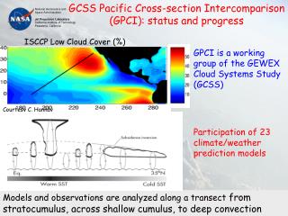
GPCI is a working group of GCSS GCSS (GEWEX Cloud System Study) is developing better parameterizations of cloud systems for climate models by improving our understanding of the physical processes in different types of cloud. There are 6 working groups: • Boundary Layer Clouds • Cirrus Cloud Systems • Extra Tropical Layer Clouds • Precipitating Convective Cloud Systems • Polar Clouds • GPCI - GCSS Pacific Cross-section Intercomparison Cases Studies using SCM/CRM/LES Overall performance in 3D climate models (GCM/RCM)
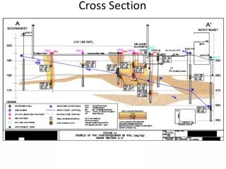
GPCI is a working group of GCSS • GPCI focuses on the physics, including clouds, turbulence, convection and radiation, in the 3D climate models. • Model results are analyzed along a cross-section in the Pacific, from the stratocumulus regions off the coast of California, across the shallow cumulus areas, to the deep convection regions of the ITCZ. • Free to choose model resolution and domain • Run in climate mode with SST prescribed (June-July_August started from May 20, 1998 and 2003) • Simple but efficient (1 section, 3 clouds)
Datasets GPCP 1DD GPCP high resolution daily data (0.5° PCP) TRMM Tropical Rainfall Measurement Mission (0.25° PCP) SSM/I Special Sensor Microwave/Imager (CLW and PW) ISCCP International Satellite Cloud Climatology Project (CLDT) CERESClouds and the Earth’s Radiant Energy System (OLR) WHOI Woods Hole Oceanographic Institution (QLA and HFS) ERA40 ECMWF reanalysis (1998) (CLDT CLWT PCVW PCPS PCPC HFS QLA FSS FDL FSG FSS FST OLR FLTC FLGC FSTC FSGC) NRA2 NCEP/NCAR reanalysis II (CLDT PCPT HFS QLA FSS FDL)
SSM/I GEM 500 JJA 1998 450 ERA-40 400 30-50g/m2 50-75g/m2 SSM/I 350 BMRC 300 CSU MMF 250 GISS 200 GKSS 150 GEM 100 CRCMM 50 0 -1 2 5 8 11 14 17 20 23 26 29 32 35 Cloud liquid water (g/m2) Is GEM a bad model?
100 ISCCP ERA-40 80 ISCCP ERA40 BMRC 60 CSU MMF GISS 40 GEM GKSS NCEP G&M3 10% more 40% less 20 GEM CRCMM JJA 1998 0 2 5 8 11 14 17 20 23 29 32 35 -1 26 latitude (degrees) Cloud cover (%)
GEM TRMM GPCP convective stratiform Precipitation (mm/day)
Zonal wind (m/s) Meridional wind (m/s)
Sensible heat flux (W/m2) GEM WHOI NRA2 ERA40 Latent heat flux (W/m2)
GEM ERA40 Shortwave radiation (W/m2)
ERA40 GEM Longwave radiation (W/m2) GEM CERES
GEMLAM_PSC GEMLAM_REG GEM SSM/I GEMLAM_PSC - precipitating shallow convection GEMLAM_REG -precipitating shallow convection scheme, moist TKE PBL, the turbulent mixing length of Blackadar rather than Bougeault-Lacarrere, surface roughness over water according to Charnock.
GEMLAM_PSC GEMLAM_REG GEM ISCCP GEMLAM_PSC GEMLAM_REG GEM TRMM ERA40
SUMMARY • GEM well simulates the precipitable water in the atmosphere but significantly underestimates the CLW in the stratocumulus region (>=50g/m2 less than SSM/I) and overestimates CLW in the shallow regions (20~50g/m2) (a precise partitioning/prognostic method is needed). • GEM very well simulates the seasonal mean precipitation along the cross-section except in the transition area between deep and shallow convection (too strong/too many deep convection in the transition). • GEM definitely underestimates (40% less than ISCCP) Sc cloud but overestimates about 10% shallow and deep cumulus.(more work need to be done).
SUMMARY • GEM realistically simulates the basic structures of relative humidity except a little dry in the upper troposphere (need a preciser diagnostics from RH ---> cloud). • GEM well simulates the zonal wind and meridional wind; also the components of the Hadley circulation including the ascending branch in the ITCZ and the descending in the mid-latitude. • GEM simulated surface fluxes and radiation are quite close to the Observation/Reanalysis.