Download
1 / 13
130 likes | 369 Views
GEODETIC INFRASTRUCTURE. Walter Volkmann Manager of Technical Operations L. D. Bradley Land Surveyors Gainesville, Florida. GEODETIC INFRASTRUCTURE. Pre-Satellite Epoch. Astronomical Observations (Laplace Fixes) & Base Line Extensions with Classical Triangulation (10ppm) Spirit Levelling

E N D
GEODETIC INFRASTRUCTURE Walter Volkmann Manager of Technical Operations L. D. Bradley Land Surveyors Gainesville, Florida
GEODETIC INFRASTRUCTURE Pre-Satellite Epoch • Astronomical Observations (Laplace Fixes) & Base Line Extensions with Classical Triangulation (10ppm) • Spirit Levelling • Introduction of EDM - control of scale in triangulation networks, geodetic traversing with astro. Obs. to control orientation Brief History Cumbersome and slow Ad Hoc extensions of network, often disconnected Difficult to maintain homogeneity across country Horizontal separate from vertical
GEODETIC INFRASTRUCTURE Satellite Epoch • Doppler Surveys - World wide coverage, absolute positioning accurate to 1m. Highly specialized application. • GPS - Global, diverse applications with accuracies from 30m to mm (1ppm) • GNSS – GPS, Glonass, Galileo?
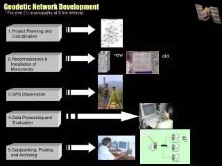
GEODETIC INFRASTRUCTURE 1. Physical Monumentation Components 2. Abstract Parts 3. Enhancing Facilities
GEODETIC INFRASTRUCTURE PHYSICAL MONUMENTATION Stable and Permanent Protected by Law (Public Property) Accessible Appropriate density Visibility conditions
GEODETIC INFRASTRUCTURE NUMERICAL AND VERBAL ATTRIBUTES 3D Position, XYZ & φλhe on specified datum and ref ellipsoid Accuracy Statement Description (digital photo) Visibility conditions Recovery notes Ideally this info should be maintained in an internet accessible database which allows users to contribute to the recovery history
AQ2646 *CURRENT SURVEY CONTROL AQ2646 ___________________________________________________________________ AQ2646* NAD 83(2007)- 29 58 59.99370(N) 081 45 05.91906(W) ADJUSTED AQ2646* NAVD 88 - 20.74 (meters) 68.0 (feet) GPS OBS AQ2646 ___________________________________________________________________ AQ2646 X - 793,238.641 (meters) COMP AQ2646 Y - -5,471,977.426 (meters) COMP AQ2646 Z - 3,168,769.766 (meters) COMP AQ2646 LAPLACE CORR- -0.88 (seconds) DEFLEC99 AQ2646 ELLIP HEIGHT- -7.308 (meters) (02/10/07) ADJUSTED AQ2646 GEOID HEIGHT- -28.05 (meters) GEOID03 AQ2646 GEODETIC INFRASTRUCTURE AQ2646 ------- Accuracy Estimates (at 95% Confidence Level in cm) -------- AQ2646 Type PID Designation North East Ellip AQ2646 ------------------------------------------------------------------- AQ2646 NETWORK AQ2646 FLGPS 31 1.12 0.96 2.25 AQ2646 ------------------------------------------------------------------- AQ2646 AQ2646.The horizontal coordinates were established by GPS observations AQ2646.and adjusted by the National Geodetic Survey in February 2007. AQ2646.The orthometric height was determined by GPS observations and a AQ2646.high-resolution geoid model using precise GPS observation and AQ2646.processing techniques. It supersedes the leveled height previously AQ2646.determined for this station. AQ2646.The ellipsoidal height was determined by GPS observations AQ2646.and is referenced to NAD 83. AQ2646 AQ2646.The geoid height was determined by GEOID03.
AQ2646_U.S. NATIONAL GRID SPATIAL ADDRESS: 17RMP2749217176(NAD 83) AQ2646_MARKER: F = FLANGE-ENCASED ROD AQ2646_SETTING: 59 = STAINLESS STEEL ROD IN SLEEVE (10 FT.+) AQ2646_SP_SET: STAINLESS STEEL ROD IN SLEEVE AQ2646_STAMPING: FLGPS 31 1988 AQ2646_MARK LOGO: NGS AQ2646_PROJECTION: FLUSH AQ2646_MAGNETIC: N = NO MAGNETIC MATERIAL AQ2646_STABILITY: B = PROBABLY HOLD POSITION/ELEVATION WELL AQ2646_SATELLITE: THE SITE LOCATION WAS REPORTED AS SUITABLE FOR AQ2646+SATELLITE: SATELLITE OBSERVATIONS - November 10, 2006 AQ2646_ROD/PIPE-DEPTH: 24.4 meters AQ2646_SLEEVE-DEPTH : 0.9 meters GEODETIC INFRASTRUCTURE AQ2646 HISTORY - Date Condition Report By AQ2646 HISTORY - 1988 MONUMENTED NGS AQ2646 HISTORY - 19890424 GOOD AQ2646 HISTORY - 19890530 GOOD AQ2646 HISTORY - 19931014 GOOD NGS AQ2646 HISTORY - 19950110 GOOD KEISCH AQ2646 HISTORY - 19960218 GOOD FLDEP AQ2646 HISTORY - 20030820 GOOD FLDEP AQ2646 HISTORY - 20050109 GOOD FLDEP AQ2646 HISTORY - 2006 GOOD FLDEP AQ2646 HISTORY - 20061110 GOOD BAKER
MODERN FEATURES Continiously Operating Reference Stations (CORS) GEODETIC INFRASTRUCTURE Raw observations archived and streamed to internet Connection to internet via land lines or cell phone Users can retrieve archived obs for in house post processing Users can submit (on Line) own obs to processing center for post processing of base lines (OPUS)
MODERN FEATURES Real Time Applications GEODETIC INFRASTRUCTURE Single Base Line real time solutions – range limits because of ionospheric effects Virtual Reference Station Technology – eliminates ionospheric effects and serves differential corrections over wide areas Significant improvements in efficiency Automated control over datum usage Powerful tool to migrate spatial data from superseded to current datum Opportunities for online collaboration – Public/Private – Field/Office Autonomous field operations
MODERN FEATURES GEODETIC INFRASTRUCTURE SERVICE CERTIFICATION TELEMETRY STANDARDS MOORE’S LAW!!!!!!!!!!!!!!!!!!!!!!
OPERATING EXAMPLE GEODETIC INFRASTRUCTURE