Download
1 / 1
20 likes | 206 Views
GEOPHYSICAL STUDY OF A VOLCANIC EDIFICE FOR COMPARISON WITH MUON IMAGING. Lénat , J-F., Portal, A., Labazuy , P. and Tomuvol colaboration (http://tomuvol.fr). Laboratoire Magmas et Volcans,Univ . Blaise Pascal-CNRS-IRD, Clermont-Ferrand, France . INTRODUCTION.

E N D
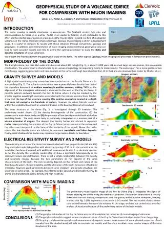
GEOPHYSICAL STUDY OF A VOLCANIC EDIFICE FOR COMPARISON WITH MUON IMAGING Lénat, J-F., Portal, A., Labazuy, P. and Tomuvolcolaboration(http://tomuvol.fr) Laboratoire Magmas et Volcans,Univ. Blaise Pascal-CNRS-IRD, Clermont-Ferrand, France INTRODUCTION The muon imaging is rapidly developing in geosciences. The ToMuVol project (see also oral communications by Niess et al. and by Portal et al.; poster by Miallier et al.) contributes to this effort and has started experiences on a lava dome (the Puy de Dôme) located in a field of monogenic volcanoes in the France mainland (Chaîne des Puys). Because muon imaging is still in a development stage, it is useful to compare its results with those obtained through conventional geology and geophysics. In addition, joint interpretation of muon imaging and conventional geophysical data can lead to more accurate models and help to define the optimal procedure to study the static and dynamic structures of active volcanoes. Fig.3 Fig.4 Fig.1 Fig.5 We present the first results from the geophysical study of the dome. The other aspects (geology, muon imaging) are presented in companion presentations. MORPHOLOGY OF THE DOME The trachytic dome, less than 2km wide at its base and about 400 m high (Fig. 1), is about 11,000 years old. As most large volcanic domes, it is a composite construction. The western half is characterized by an uneven morphology corresponding mostly to massive rocks. The eastern part has a more gentle surface morphology, suggesting pyroclastic and talus deposits at the surface although lava lobes less than 10 m thick are also observed (see poster by Miallier et al.). Bouguer anomaly GRAVITY SURVEY AND MODELS A high spatial resolution gravity survey has been carried out on the Puy de Dôme and its surroundings (Fig. 2). The volcanic constructions have a generally lower density than that of the crystalline basement. A medium wavelength positive anomaly, striking ~N15 (as the alignment of the monogenic volcanoes) is observed to the west of the Puy de Dome. It possibly extends eastward beneath the Puy de Dôme where it may be masked by the shorter negative wavelength anomalies associated with the volcanic constructions. Models show that the top of the structure creating this positive anomaly is located at a depth that does not exceed a few hundreds of meters. However, its nature (density contrast within the crystalline basement or volcanic intrusion in the basement) is not yet resolved. Fig.2 The inner structure of the dome (Fig. 3) is investigated through 3D inversion. The preliminary model shows: (1) the density heterogeneity of the construction, (2) the presence of a main dense body and (3) the presence of low density material both at shallow and deep levels. The main dense body is tentatively interpreted as a massive part of a viscous extrusion of magma. The deepest low density bodies are inferred to represent cinder cones predating the eruption of the Puy de Dôme (some crop out at the surface and the others are interpreted on the base of the similarity of the signal). Above the cinder cones, the low density zones are inferred to represent pyroclastic and talus deposits. Finally, small shallow dense bodies may represent large massive blocks or lava lobes. ELECTRICAL RESISTIVITY SURVEY AND MODELS Resistivity sections The resistivity structure of the dome has been studied with two perpendicular (NS and EW) long multi-electrode (64) profiles with electrode spacing of 35 m. In the summit area the resolution has been increased with additional measurements with 5 m electrode spacing. As for the density, the resistivity models (Fig. 4) show a significant heterogeneity in the resistivity values and distribution. There is not a simple relationship between the density and resistivity images, because the two parameters do not depend of the same characteristics of the rocks. The rock resistivity depends on the content and nature of the fluid (usually water), the permeability and the alteration of the rocks (presence of hydrated minerals). However, good agreements between some resistivity and density structures are observed in some areas. For example, the inferred cinder cones buried beneath the Puy de Dôme are characterized by low density and high resistivity. N S W E COMPARISON WITH MUON IMAGING S N The preliminary muonopacity image of the Puy de Dôme(Fig. 5) integrates the signal of muons crossing the dome along the west–east direction. Since muon attenuation is linearly linked with the rock density, comparisons with the gravity models can be attempted, keeping in mind that Fig. 3 (SN) represents a section in a 3-D model. The two models show a dense core located beneath the top of the volcano. At this stage, we have not carried out a detailed analysis of structures because of the preliminary nature of the both models. Muon opacity of the Puy de Dôme from the East (1) The geophysical studies of the Puy de Dôme are crucial to validate the capacities of muon imaging of volcanoes. (2) The geophysical models suggest a more complex structure of the Puy de Dôme than initially expected from the geology. (3) On going complementary geophysical measurements (magnetic survey, measurement of some physical properties of rock samples from the studied area) will help to constrain the models and therefore to obtain more precise images of the inner structure of the area. CONCLUSIONS