Download
1 / 34
340 likes | 465 Views
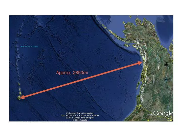
Approx. 2850mi. Migratory Movements of Individual Humpback Whales and their Navigational Mechanisms. Migratory Paths taken by whales can give insight to how they navigate. How narrow are the migratory pathways of individual humpback whales? Do they take specific routes year after year?

E N D
Migratory Movements of Individual Humpback Whales and their Navigational Mechanisms Migratory Paths taken by whales can give insight to how they navigate
How narrow are the migratory pathways of individual humpback whales? Do they take specific routes year after year? How specific are these routes?
These are the small questions behind the BIG MYSTERY How do humpback whales navigate such great distances with precision and accuracy?
How did we do it? We look into the best navigators of our species to get an idea of possible features of humpback whale navigation
Ancient Polynesian Way Finding • Clouds • Waves • Winds • Currents • Sun • Moon • Stars • Ocean Swells • Flight patterns of birds Paired with ingrained geographic knowledge
Way Finding Training Navigator priests learned information passed down Poetic Chants pass down information about routes. Sitting in a stone canoe on land and memorizing the patterns of sun, moon, and stars Primative maps with swells, winds, currents, and islands Humpback Whales may also be linking social following, learned behavior, and singing.
Retracing familiar routes? Narrow paths vs. Variable paths
Migratory pathway characteristics: very straight, abrupt course corrections, meandering Give insight into Navigational mechanisms humpbacks use: compass-like orientation via visual cues, or geomagnetic cues, a social following behavior, sonar mapping of the ocean floor
Route Characteristics • A) the route is direct, point-to-point, without much deviation; • B) Route lacks directionality, meandering; • C) route is relatively straight in segments, but includes a distinct course correction; • D) route meanders but does show course correction. ???
Repeated or Not? Each of these characteristic has two components: R=the route is conservatively repeated V=the subsequent route is not similar/ variable
Grand Total 8 characteristics to look for in route Ar, Br, Cr, Dr And Av, Bv, Cv, Dv
4 Possible Primary Mechanism Groups • Compass like orientation using visual cues (stars, moon, sun) • A social following behavior utilizing their vocalizations • Sonar mapping of the ocean floor • Orientation to the geomagnetic field
Compass like orientation using visual cues Av and Cv, because compass like navigation could help them keep a bearing but not necessarily repeat their trip
A social following behavior would correlate with Bv and Dv because it logically has no distinct ability of strong directionality but definite inherent course correction. Also possibly Av and Cv, depending on have strong these vocalizations are
Sonar mapping of the ocean floor Ar, Br, Cr, and Dr as they would be using geographic knowledge from previous experiences just as the Polynesians, allowing them to follow distinct landmarks and boundaries of a route.
Orientation to the geomagnetic field also a compass like technique and therefore we would expect a good directionality but not necessarily repeated occurrences so Av and Cv. More likely Av (less course corrections than when using visual signals)
These hypothesized connections will then be linked with the data collected to determine the most likely mechanisms used in humpback navigation.
Collecting Data • Tagging whales once a year in Alaska using a long fiberglass pole to implant the tag into the blubber
Collecting Data • Tagging whales once a year in Alaska • Argos satellite locations calculated and sent with ratings attached (3, 2, 1, 0, A, B) • Using high quality location points to map routes or disregarding implausible points
Linearity Described by the “Directness Index” A B 100 [ ] Distance between the first and last point in the migration Total distance traveled in Route =
Deviation Index The mean of the absolute value of anglular deviations from straight paths beyond previous locations Angle 1 Angle 2 B A | angle 1| + | angle 2| = 2
Conserved Routes Determined by overlap or within x distance of previous routes
From the data we can determine which characteristics are conserved and which are not in individual whales and over the entire sample. With this information we can further look into particular factors more likely involved in navigation.