Download
1 / 14
160 likes | 383 Views
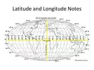
Guided Notes on Latitude and Longitude. Define Cartography:. Cartography is the science of mapmaking. What is the equator? Where is it located?. The equator separates the Earth into 2 hemispheres. It circles the Earth halfway between the North and South Poles.

E N D
Define Cartography: • Cartography is the science of mapmaking
What is the equator? Where is it located? • The equator separates the Earth into 2 hemispheres. It circles the Earth halfway between the North and South Poles
Define and describe Latitude and Lines of Latitude • Latitude is the distance in degrees north or south of the equator • Lines running parallel to the equator are lines of latitude
Each degree of latitude is equal to 111km. To locate positions on Earth more precisely, cartographers break down degrees of latitude into sixty smaller units called minutes.
One minute of latitude is equal to 1.85 km. Minutes of latitude can be divided into 60 seconds.
Define and describe Longitude and Lines of Longitude • Longitude is the distance in degrees east or west of the prime meridian. • Lines of longitude locate positions in east or west directions.
What is the Prime Meridian? Where is it located? • The prime meridian is a line of longitude that represents 0° longitude. It runs from the north pole to the south pole through Greenwich, England.
Unlike lines of latitude, lines of longitude are not parallel. Instead, they are large semicircles that extend vertically from pole to pole.
180° longitude is also known as the International Date Line.
The distances covered by degrees of longitude vary with location. One degree of longitude varies from about 111km. at the equator to a point at the poles.
In reference to the coordinates of a particular location, latitude always comes first.
Why is the earth divided into 24 time zones? • Each time zone represents one hour in the 24 hours it takes for the earth to rotate on its axis.
Each time zone is 15° wide, but some boundaries are adjusted because they would run through cities in which it would be confusing to have 2 different times.