Download
1 / 36
360 likes | 364 Views
Explore how air masses and fronts affect weather patterns, including the types of air masses, the characteristics of different fronts, and the behavior of high and low pressure systems.

E N D
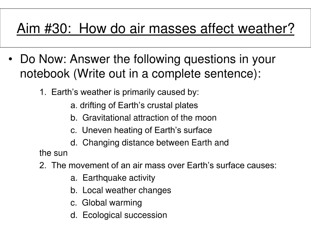
Aim #30: How do air masses affect weather? • Do Now: Answer the following questions in your notebook (Write out in a complete sentence): 1. Earth’s weather is primarily caused by: a. drifting of Earth’s crustal plates b. Gravitational attraction of the moon c. Uneven heating of Earth’s surface d. Changing distance between Earth and the sun 2. The movement of an air mass over Earth’s surface causes: a. Earthquake activity b. Local weather changes c. Global warming d. Ecological succession
Air Mass Large body of air that has same temp & amount of moisture throughout
Humid = form over water • Dry = form over land • Warm = form over warm areas • Cold = form over cold areas
Polar Air Mass = cold air mass • 1. Continental polar = dry & cold • 2. Maritime polar = cold & humid
Tropical Air Mass = warm air mass (forms over equator) • 1. Continental tropical = warm & dry
Aim#31: How do fronts affect weather? *Do Now: 1) Take out Weather Log to be checked for HW grade 2) (Review) Create a table in your notebook to explain the 4 types of air masses. (Please include their symbols.) • H.W. • Weather Log- Monday • “What is an air mass” worksheet (handed out Thursday)
http://www.classzone.com/books/earth_science/terc/content/visualizations/es2001/es2001page01.cfmhttp://www.classzone.com/books/earth_science/terc/content/visualizations/es2001/es2001page01.cfm
Front Region between air masses Changes in weather occur here (usually precipitation)
Types: 1. Cold Front = • when cold air mass pushes into & under warm air mass http://www.stevemcentee.com/animation3.html
2. Warm Front = • when warm air mass pushes over cooler air mass http://www.stevemcentee.com/animation3.html
3. Stationary Front = • when a cool & warm air mass stay in one place for a while http://www.stevemcentee.com/animation3.html
4. Occluded Front = • a warm air mass is caught between two cooler air masses http://www.stevemcentee.com/animation3.html
Aim #32: How can we compare high and low pressure systems? *Do Now: Use the venn diagram to compare and contrast a cold front to a warm front. cold front warm front H.W. 1)Weather Log- Tuesday 2) Measuring Up- pg. 220
*Do Now: Use the venn diagram to compare and contrast a cold front to a warm front (you can include stationary front to the similarities).
Cold front: A = cold air; B = warm air. Here cold air moves towards a warm air mass and forces the warm air to rise. Warm front: A = cold air; B = warm air. Here warm air moves towards a mass of cold air and rises. http://www.classzone.com/books/earth_science/terc/content/visualizations/es2002/es2002page01.cfm?chapter_no=visualization
Aim #32(b): How can we compare high and low pressure systems? *Do Now: Choose a city on the weather map to the right and describe the weather conditions. H.W. 1)Weather Log- Wednesday 2) Using a weather map worksheet #s -
“How weather systems move from place to place”- video http://player.discoveryeducation.com/index.cfm?guidAssetId=639C0D60-31EA-4C11-97E5-89DDF081A328&blnFromSearch=1&productcode=US
High Pressure System “Highs” (anti-cyclones) Center of air masses Clear skies, dry weather, gentle winds
Air currents move out • Winds blow clockwise in northern hemisphere
Low Pressure System “Lows” (cyclones) Edges of air masses Cloudy, wet, strong, gusty wind
Air currents move in • Winds blow counterclockwise in northern hemisphere
How can we remember the characteristics of pressure systems?