Download
1 / 76
1.99k likes | 4.42k Views
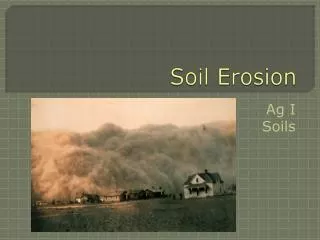
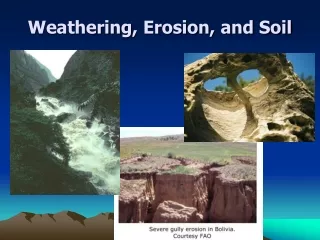
Soil Erosion and Conservation. “Erosion”. a natural leveling process that wears down high places; fills in low places agents : running water, ice, wind, gravity, waves. “accelerated erosion”.

E N D
“Erosion” • a natural leveling process that wears down high places; fills in low places • agents: running water, ice, wind, gravity, waves
“accelerated erosion” • Process by which soil particles are removed, transported and deposited; rate of removal of soil greater than rate of formation • 500 yrs / inch topsoil • Caused by removal of vegetation • agents: wind, water
Deposition or sedimentation is flip side of erosion. • the soil that is removed has to go somewhere: wetlands, lakes, streams, atmosphere
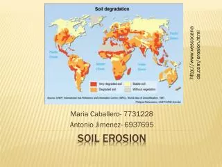
Minnesota 154 million tons of topsoil / year 96% cropland water erosion 42% wind erosion 58%
Worldwide 75 billion metric tons soil lost / year (predominantly cropland) 80% cropland: moderate - severe erosion 10% cropland: slight - moderate erosion highest rates in Asia, Africa, South America
United States • In past 200 yrs, 30% of US farmlands have been abandoned due to erosion, salinization and waterlogging • wind erosion increasing • water erosion decreasing • 90% US cropland losing soil above sustainable rate • croplands: lose 17 tons/ha/yr • pastures: lose 6 tons/ha/yr
In U.S…. • In past 50 yrs, average farm size change: • 90 to 190 ha (225 to 475 acres) • to create larger fields: remove shelterbelts, grass strips, hedgerows • use of heavier machinery damages soil
Short History of Agriculture Post WWII: • Increase in chemical/mechanical intensive production practices • Decrease in number of farms • Increase in size of farms • Production of commodities/export crops • Top 5 commodities (2003) • Cattle, dairy, corn, soybeans, broilers • Cheap food policy • Over-production, cost-price squeeze, consolidation of farms
Farm CrisisSince 1980’s • Falling prices • Spiraling overproduction • Bankruptcies, foreclosures
1. Water erosiona. rainsplash erosion • Raindrops accelerate as fall until they reach speed at which friction balances gravity • for large raindrops: 30 km / hr • transfer kinetic energy to soil: • detach soil • destroy structure • transport soil (as much as 0.7 m vertically and 2 m horizontally) • Only in intense rain events; soil stays local
b. sheet erosion Water flows smoothly in a thin film over surface; detached soil moves with the water
c. rill erosion • Sheet flow concentrates water into channels
d. gully erosion • Water cuts deeper into soil, rills coalesce into deep troughs • cannot (easily) be removed by tillage • most dramatic, but most soil loss is due to sheet and rill erosion
Universal Soil Loss Equation (USLE) A = RKLSCP R : rainfall erosivity(intensity, quantity) K : soil erodibility(erosion rate per unit of R; in Soil Survey) L : slope length S : slope gradient C : cover and management (ratio of soil loss compared to fallow) P : erosion-control practices
2. Wind erosion • Arid and semi-arid climates • Dry soil; loss of structure; wind can remove soil particles • Damage is on-site and off-site
Smallest detach into suspension (<0.1 mm) • medium move bysaltation (0.1 - 0.5 mm) • large move by rolling and sliding (creep) > 0.5 mm
Wind Erosion Model (WEQ) E = ƒ( ICKLV) I : soil erodibility (slope angle, soil moisture, structural stability) C : climate factor (wind speed , soil temp., ppt.) K : roughness factor L : width of field factor V : vegetative cover
Soil Conservation Measures US gov’t response to Great Dust Bowl: 1. SES---SCS---NRCS 2. 3000 Soil and Water Conservation Districts 3. Shelterbelt Program 218 million trees
USDA’s “tolerable soil loss” 2 - 11 metric tons / ha / yr. (11 = 5 tons/acre/yr) not sustainable : soil formation rate = 0.5 tons / acre/yr
Prevention practices: 1. Windbreaks Plant trees on windward side of crops 30 mph --> 13 mph