Download
1 / 14
150 likes | 212 Views
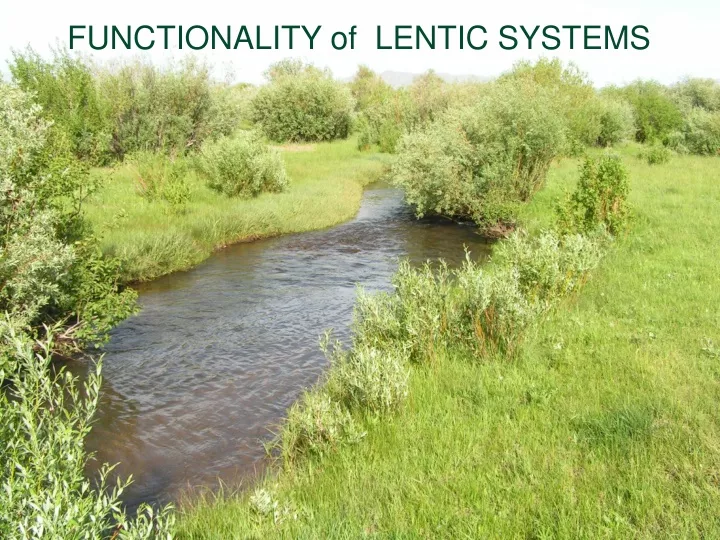
FUNCTIONALITY of LENTIC SYSTEMS. LENTIC STANDING WATER HABITAT SUCH AS LAKES, PONDS, SEEPS, BOGS and MEADOWS. Lentic PFC definition. “ Lentic riparian-wetland areas function properly when adequate Vegetation, Landform or large Woody Debris is present to :

E N D
LENTICSTANDING WATER HABITAT SUCH AS LAKES, PONDS, SEEPS, BOGS and MEADOWS
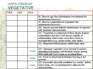
Lentic PFC definition • “Lentic riparian-wetland areas function properly when adequate Vegetation, Landform or large Woody Debris is present to: • Dissipate energies associated with wind action, wave action, and overland flow from adjacent sites, thereby reducing erosion and improving water quality
Lentic PFC definition • Filter sediment and aid floodplain development • Improve flood-water retention and ground water recharge, • Develop root masses that stabilize islands and shoreline features against cutting action. • Restrict water percolation
Lentic PFC definition • Develop diverse ponding characteristics to provide the habitat and the water depth, duration, and temperature necessary for fish production, waterfowl breeding and other uses • Support greater Biodiversity
APPROCH • Base assessment on Potential and Capability. • For example, if the system does not have wave energy, logs, or shoreline rocks, do not use that criteria • ID Team (e.g. If soils too oxygenated or saline for redoximorphic features, don’t expect them) • Understand, flow patterns, sediment transport and vegetation composition
Hydrogeomorphic: • Groundwater recharge and discharge • Flood modification • Inundation (depth, duration, & frequency) • Aquatard • Shoreline shape
Vegetation • Community types – distribution • Density and cover • Community dynamics and succession • Recruitment and reproduction • Root characteristics • Survival
Soils • Soil type • Distribution of aerobic anaerobic soils • Annual pattern of soil water states • Ponding frequency and duration • Restrictive material
Erosion/Deposition: • Shoreline stability • Depositional features
Water Quality • Temperature • pH • Dissolved solids • Dissolved oxygen
Biotic community: • Aquatic plants • Recruitment/reproduction • Nutrient use
Structures • Design stability • Materials • Overflow channels