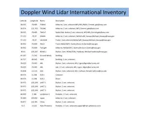
Download
1 / 15
150 likes | 366 Views
A Comparison of Doppler Lidar and Weather Balloon Wind Speed Profiles. Patrick Selmer Research and Discover – UNH Advisors: Dr. Ivan Dors and Dr. James Ryan. Tackling the Data Void.

E N D
A Comparison of Doppler Lidar and Weather BalloonWind Speed Profiles Patrick Selmer Research and Discover – UNH Advisors: Dr. Ivan Dors and Dr. James Ryan
Tackling the Data Void “The high value of tropospheric wind for improved weather prediction and climate studies is highlighted by the fact that it is ranked as the highest priority unmet measurement by NPOESS/IPO, a joint office representing DOD, NOAA and NASA.” Space LIDAR vs Radiosonde Winds Source of both images and quote: Space-based Doppler Winds LIDAR: A Vital National Need.
GroundWinds Program • Develop & demonstrate remote sensing Doppler LIDAR technologies capable of measuring wind speeds from satellite • Improve weather forecasting: Make the 5-day forecast as accurate as today’s 3-day forecast Bartlett, NH Mauna Loa, HI Source: GroundWinds Web Page Source: GroundWinds Web Page
Objectives • Compare LIDAR and Weather Balloon wind profiles quantitatively • Characterize inherent differences between the two measurement techniques • Extract any other useful information from the comparison
Doppler LIDAR vs. Weather BalloonCharacteristic Differences • LIDAR • Time Averaged • Fixed (ground) • Remote Sensor • Azimuth Sampled Weather Balloon • Instantaneous • Drift (wind) • In Situ • Single Sampled
Comparative MeasurementsDecember 11, 2002 Spatial Overlap Balloon 1 Balloon 2 Balloon 3 Adapted from Jumper Image to scale
Comparative Measurements Temporal Overlap December 11th local, 12th UTC (Weather Balloons) 394 379 394 409 379 364 349 379 379 379 364 349 10 2 8 9 11 12 3 4 6 7 1 5 Time UTC Adapted from Jumper
Wind Speed Comparison Can be thought of as the average error per altitude for a given pair of wind profiles Fit ErrorSSR = Σ(Ulidar – Urad)2 n
Method of Comparison • The 12-azimuth LIDAR data set was split-up to provide numerous wind profiles for comparison 12 Total Azimuth Scans 10 Sets of Three 9 Sets of Four 2-4 3-5 4-6 …10-12 1-4 2-5 3-6 4-7 …9-12 1-3
Predictions • Agreement between the wind profiles will improve with • Increased LIDAR azimuth angle span • Increased temporal overlap of measurements • Increased number of azimuths
Temporal OverlapAnticipate better agreement with coincident measurements Both 3 and 4-azimuth profile results Balloon 3 Launch
Conclusions • Agreement increased with scanning range • Agreement was not time-dependent • Steady atmosphere or not a dominant effect • Agreement increased with the number of azimuth angles used • Using all twelve azimuths gave the best match
Acknowledgements Special thanks to Dr. Ivan Dors for providing data and software and for all his help and support. I would also like to thank Dr. Jim Ryan, Dr. George Hurtt, and the entire Research and Discover team for making this presentation possible
Burroughs, John. "Data Coverage." Integrated Global Radiosonde Archive (IGRA). NESDES, 20 Aug. 2008. Web. 26 July 2009. <http://www.ncdc.noaa.gov/oa/climate/igra/index.php?name=coverage>. References Institute for the Study of Earth, Oceans and Space University of New Hampshire. GroundWinds. University of New Hampshire. Web. 29 July 2009. <http://groundwinds.sr.unh.edu/index.html>. Jumper, George Y. Hawaii 2002 Thermosonde Campaign. Rep. Hayes, Paul, et al. Space-based Doppler Winds LIDAR: A Vital National Need. Rep. 2005. Print.