Download
1 / 44
440 likes | 605 Views
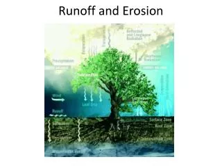
Canadian Prairie Hydrology and Runoff Generation. John Pomeroy Centre for Hydrology, University of Saskatchewan, Saskatoon www.usask.ca/hydrology. Prairie Hydrology.

E N D
Canadian Prairie Hydrology and Runoff Generation John PomeroyCentre for Hydrology, University of Saskatchewan, Saskatoon www.usask.ca/hydrology
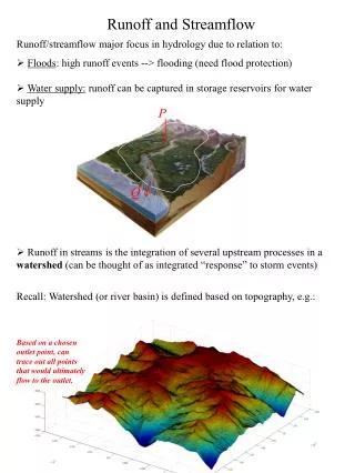
Prairie Hydrology • Major river flow is primarily from mountain runoff, but prairie runoff supplies smaller rivers, streams, wetlands, and lakes • Prairie Runoff • forms in internally drained (closed) basins that are locally important but non-contributing to river systems that drain the prairies, OR • drains directly to small prairie rivers (Battle, Souris, Assiniboine) >80% of runoff during snowmelt period • Redistribution of snow to wetlands and stream channels in winter is critical to formation of runoff contributing area • Drainage of small streams and wetlands ceases completely in summer when actual evaporation* consumes most available water. • Baseflow from groundwater often nonexistent. • Prairie streams are almost completely ungauged and often altered by dams, drainage, water transfers, etc *evaporation used here as transpiration + evaporation + sublimation
Prairie Runoff Generation Snow Redistribution to Channels Spring melt and runoff Dry non-contributing areas to runoff Water Storage in Wetlands
Non-Contributing Areas to Streamflow a Prairie Characteristic
Prairie Hydrology – don’t blink Smith Creek, Saskatchewan Drainage area ~ 450 km2 No baseflow from groundwater
Information Needed to Estimate Runoff • Snow accumulation and redistribution • Melt rate • Infiltration to frozen soils • Infiltration excess forms runoff • >80% of all runoff is snowmelt runoff
Blowing Snow: Transport, Sublimation and Redistribution of Snow Pomeroy and Gray, Wat Resour. Res. (1990) Pomeroy and Male, J Hydrol. (1992) Pomeroy, Gray and Male, J Hydrol. (1993) Pomeroy and Gray, NHRI Science Report No. 7 (1995)
Effect of Blowing Snow Sublimation on Prairie Snow Supply (losses, mm SWE) 1970-1976 hourly simulations Pomeroy and Gray, NHRI Science Report No. 7 (1995)
Stubble Field Grassland Brush Trees Source Sink Fallow Field Distribution of Blowing Snow over Landscapes Blowing snow transport, and sublimation relocate snow across the landscape from sources to sinks depending on fetch, orientation and area.
Shelterbelts on Prairies Winkler, Manitoba Transport to shelterbeltsdepends on upwind fetchand vegetation roughness Conquest, Saskatchewan
Spatially Distributed Snow Redistribution Snow mass balance equation St Denis, Saskatchewan
Results – Spatially distributed SWE Fang and Pomeroy, Hydrol Proc, in preparation
Snowmelt • Degree Day Method has problems in open environments with late melt, & in forests. • Energy Balance snow CAN be estimated using reliable and readily applicable methods
Coupled Mass and Energy Equations for Snowmelt • MELT of SWE = QM/(w Lf Bi) • Melt Energy QM = Q* - QE – QH – QG– dU/dt • Q* Net radiation (+ to snow surface) • QE Evaporative energy (+ away from snow surface) • QH Sensible energy (+ away from snow surface) • QG Ground heat flux (+ downward from snow) • dU/dt Internal energy change (+ loss from melt)
Diurnal Variation in Radiative Fluxes - clear day near Saskatoon 700 Incoming SW 600 Net SW 500 Net Rad 400 Net LW Radiation (W/m²) 300 200 100 0 -100 -200 0:00 4:00 8:00 12:00 16:00 20:00 24:00 Time
Empirical atmospheric transmittance equations • Qsi can be calculated directly if the atmospheric transmittence is known • Many similar relationships, all give similar results: • Bristow and Campbell and Walter et al. • Annandale • All use a simple relationship between daily atmospheric transmittance and the range of daily air temperatures
Infiltration to Frozen Soils • Frozen soils can be permeable, but show reduced infiltration compared to unfrozen conditions • ‘Frozen’ means a frost depth of at least 0.5 m • Simple grouping of soil types Three classes of infiltrability: unlimitedInf=SWErestrictedInf=0 limited Inf = f(SWE, Saturation)
Gray’s Model of Infiltration into Frozen Soils - Prairie Environment 120 Unlimited Restricted 100 Saturation 1:1 80 0.3 0.4 Infiltration (mm) 60 0.5 0.6 40 0.7 20 0.9 0 0 30 60 90 120 150 180 Snow Water Equivalent (mm)
Local Scale Prairie Runoff • Because of frozen soils and rapidly melting snowcovers in the spring, 80% - 90% of prairie runoff is produced from snowmelt • Snowmelt runoff is strongly controlled by snow drift location and size, soil moisture and mid winter thaws. • In wet years, there is often excess water to dryland cereal grain growing needs. • Hydrological computer simulations may tell us something about the reliability and behaviour of local prairie water supplies
Cold Regions Hydrological Model • Prairie hydrological modelling requires consideration of the following: • Transport of water in liquid, vapour and frozen states (runoff, percolation, evaporation, • sublimation, blowing snow); • 2. Coupled mass and energy balances; • 3. Phase change in snow & soils (snowmelt, infiltration in frozen soils, soil freezing and thawing); • 4. Snow and rain interception in forest canopies; • Episodic flow between soil moisture, groundwater, ponds and streams. • Variable storage, drainage and contributing area • Land use change
Data from multiple sites Interpolation to the HRUs Infiltration into soils (frozen and unfrozen) Snowmelt (prairie & forest) Radiation – level, slopes Evapotranspiration Snow transport Interception (snow & rain) Sublimation (dynamic & static) Soil moisture balance Sub-surface runoff Routing (hillslope & channel) Advection CRHM Module Development DATA ASSIMILATION PROCESSES SPATIAL PARAMETERS • Basin and HRU parameters are set. (area, latitude, elevation, ground slope, aspect)
Creighton Tributary, Bad Lake as a typical Prairie Basin Moderately well drained plateau of grains and fallow drains into a couleeSemi-arid to sub-humid climateTypical drainage and landcover for much of southern prairies
Snowmelt Runoff over Frozen Soils Bad Lake:Semi-arid SW Saskatchewan Soil moisture is FALL soil moisture Snowmelt runoff is Spring Physically based Infiltration equations (Zhao & Gray, 1999) Cold Regions Hydrological Model
Bad Lake – Creighton Tributary Water Balance With 30% Summer Fallow Pomeroy, De Boer, Martz (2007)
Prairie Streamflow & Climate Change “first more, then less” • Three most “reliable” climate change scenarios for hydrology suggest increases in annual prairie winter temperature and precipitation from the 1961-1990 average: • 2050 +2.6 ºC and +11% • 2080 +4.7 ºC and +15.5% • Using these scenarios in the virtual upland basin results in a 24% rise in 2050 spring runoff, but a 37% drop by 2080, compared to conditions in the mid 1970s.
Conclusions • Prairie hydrological processes that control water balance and runoff generation have been largely quantified and described and model requirements are known, but have not been widely implemented in models. • Major unknowns are the changing contributing area and its interaction with surface storage terms in poorly defined drainages.