Download
1 / 6
60 likes | 61 Views
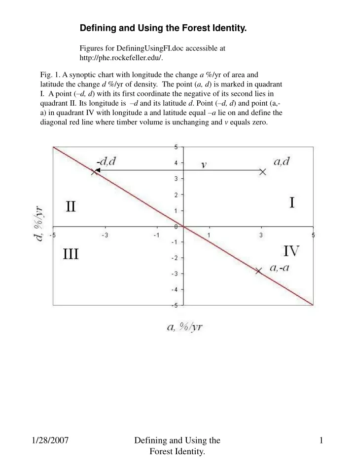
Defining and Using the Forest Identity. Figures for DefiningUsingFI.doc accessible at http://phe.rockefeller.edu/.

E N D
Defining and Using the Forest Identity. Figures for DefiningUsingFI.doc accessible at http://phe.rockefeller.edu/. Fig. 1. A synoptic chart with longitude the change a %/yr of area and latitude the change d %/yr of density. The point (a, d) is marked in quadrant I. A point (–d, d) with its first coordinate the negative of its second lies in quadrant II. Its longitude is –d and itslatitude d. Point (–d, d) and point (a,-a) in quadrant IV with longitude a and latitude equal –a lie on and define the diagonal red line where timber volume is unchanging and v equals zero. Defining and Using the Forest Identity.
Fig. 2. An idealized forest where the biomass per area M/A grows 1 tons//ha per time from time 0, whereas timber density D grows at 2 m3/ha but after time 1. The f represents the tons of timber per ton of biomass and approaches 1. B is the tons of biomass per m3 of timber and approaches the density r of timber, which is assumed 1. Defining and Using the Forest Identity.
5 4 3 2 1 d %/yr 0 -5 -4 -3 -2 -1 0 1 2 3 4 5 -1 -2 -3 -4 -5 a %/yr Fig. 3. A synoptic chart separating nations with increasing biomass northeast of the green line from those with decreasing biomass southeast of the green line. The longitude is the change a %/yr of area and latitude the change d %/yr of density. The point (a, d) is marked in quadrant I. Point (–0.7 d, d) in quadrant II with longitude equal to –0.7 d, and the point in the quadrant IV with latitude equal to –a/0.7 lie on and define the diagonal green line where timber volume is unchanging and m equals zero. If the carbon concentration in biomass does not change, the green line separating nations with increasing from those with decreasing biomass also becomes the separation for rising from falling carbon sequestration, too. The red line separates nations with increasing from those with decreasing timber volume v. m a,d -0.7 d,d II I III IV a,-a/0.7 Defining and Using the Forest Identity.
5% Austria Poland 4% Nepal Norway Czech R. 3% Chile Japan Ukraine Laos Sweden Finland Madagascar France 2% Belarus Central African R. USA Malaysia Brazil Turkey Mongolia Myanmar 1% Sudan Italy Zambia Spain Nigeria Philippines India China 0% d %/yr -4% -3% -2% -1% 0% 1% 2% 3% Cambodia Vietnam Argentina -1% Guatemala Côte d'Ivoire Panama Tanzania Papua NG -2% DR Congo Congo Angola -3% Gabon Near 0,0 Canada Romania -4% South Africa Indonesia Suriname Russia -5% French Guiana a %/yr Defining and Using the Forest Identity.
Fig. 5. The lack of a relation between the FRA2005 reports of the average 1990 to 2005 change V’ m3/yr of timber volume to the FAO reports of the 2004 harvest of timber products. Defining and Using the Forest Identity.
Fig. 6. The changes in the fractions of plantation and natural areas to match changing proportions of production from plantations and natural forests. Natural forest area Natural forest production Plantation area Defining and Using the Forest Identity.