Download
1 / 16
160 likes | 381 Views
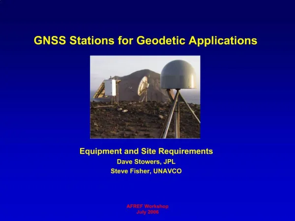
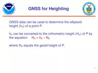
GNSS for Heighting. GNSS data can be used to determine the ellipsoid height (h P ) of a point P. h P can be converted to the orthometric height (H P ) of P by the equation: H P = h P – N P where N P equals the geoid height of P. h. N. Geoid Height (GEOID03). Ellipsoid

E N D
GNSS for Heighting GNSS data can be used to determine the ellipsoid height (hP) of a point P. hP can be converted to the orthometric height (HP) of P by the equation: HP = hP – NP where NP equals the geoid height of P.
h N Geoid Height (GEOID03) Ellipsoid (NAD 83) Geoid (NAVD 88) Ellipsoid, Geoid, and OrthometricHeights H = Orthometric Height(NAVD 88) h = Ellipsoidal Height (NAD 83) H = h - N N = Geoid Height (GEOID 03) TOPOGRAPHIC SURFACE H A B
When using GNSS in differential mode,the equation HP = hP – NPbecomes HP = (hP – ho) + ho – NPor HP = dh + ho – NPwhere ho = the adopted ellipsoid height of some previously established geodetic reference stationand dh = the measured difference in ellipsoid height between P and the geodetic reference station. GNSS for HtMod
Estimating the Uncertainty in HP In accordance with the previous equation, the standard error of HP is given by the equation: σHp = (σdh2 + σho2 + σNp2 )0.5 Here σdh = the standard error of the measured ellipsoid height difference σho = the standard error of the adopted ellipsoid height of the geodetic reference station σNp = the standard error of the geoid height at P.
Uncertainty Due to the Geoid Model For GEOID03, σNp ≈ 2.4 cm For GEOID09, σNp≈ 1.5 cm After GRAV-D, σNp≤ 1.0 cm The above standard errors represent nominal values. Actual standard errors will vary geographically as a function of the local geometry of reference stations that have both accurate orthometric heights and accurate ellipsoid heights.
Considering Different GNSS Technologies We will now consider values for σdh and σho for the following technologies: • Positioning P relative to a passive reference station • Positioning P relative to the CORS network using OPUS-S • Positioning P relative to the CORS network using OPUS-RS • Positioning P using network RTK technology
Positioning P Relative to aPassive Reference Station According to Eckl et al. ( 2001), σdh = 3.7 cm / (T)0.5 when T ≥ 4 hours and the baseline length ≥ 25 km. Here T = the duration of the observing session. Thus σdh = 1.85 cm, when T = 4 hours. σho ≤ 2.0 cm for many of the passive reference stations that participated in the NAD 83 (NSRS2007) adjustment. (There is a significant concern about unknown vertical crustal motion.) A A A A A
Positioning P relative to the CORS Network Using OPUS-S Again σdh = 3.7 cm / (T)0.5 But OPUS-S can work for T ≥ 2 hours Thus, σdh = 2.6 cm when T = 2 hours. Because OPUS-S uses three CORS and because CORS vertical velocities are known σho ≤ 1.0 cm
CORS for Monitoring Vertical Crustal Motion Vertical velocities associated with Glacial Isostatic Adjustment
Positioning P Relative to theCORS Network Using OPUS-RS σdh depends on the local geometry of the CORS network because OPUS-RS is interpolating the atmospheric refraction conditions measured at nearby CORS to estimate the corresponding refraction conditions at P. For most of CONUS, 2.0 cm ≤ σdh≤ 4.0 cm Again, σho≤ 1.0 cm because OPUS-RS uses many CORS and because CORS velocities have been determined.
Vertical standard error achievable in CONUS when a user submits 15 minutes of GPS data to OPUS-RS
Positioning P UsingNetwork RTK Technology According to a recent (Nov. 2008) study by Newcastle University 1.3 cm ≤ σdh ≤ 2.6 cm when a person performs two 3-minute sessions spaced at least 20 minutes apart, provided • Good network geometry (P is inside polygon formed by RTK network) • No significant multipath • GDOP ≤ 3 • Software indicates good “coordinate quality” Again, σho≤ 1 cm Note: The use of two sessions averages satellite geometry, multipath, and atmospheric refraction.
Positioning P UsingNetwork RTK Technology According to the study by Newcastle University: The use of GPS+GLONASS does not improve on the accuracy achievable using GPS only. However, the use of GPS+GLONASS allows RTK surveying to proceed with less downtime, especially in areas where sky visibility is somewhat obstructed. The Newcastle report is available at: www.tsa-uk.org.uk/guidance.php