Download
1 / 61
630 likes | 829 Views
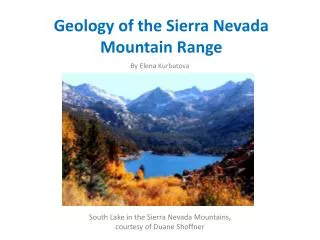
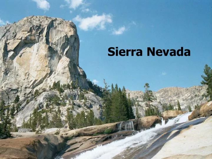
Sierra Nevada. Sierras. 400 miles long 50 mile wide Eastern ridge of the Central Valley Many peaks above 13,000 ft. Most of land in National Forest. Climate. Strong rain shadow Higher Eastern side ( Nevada) drier Biotic Zonation of forest types follows rain and temps.

E N D
Sierras • 400 miles long • 50 mile wide • Eastern ridge of the Central Valley • Many peaks above 13,000 ft.
Climate • Strong rain shadow • Higher Eastern side ( Nevada) drier • Biotic Zonation of forest types follows rain and temps. • West Wetter in Sierra at 5500 ft: • West Slope (Yosemite Valley Floor) 75" • East Slope only 20"
Precipitation: North- South • 300 miles north latitude is roughly equivalent to 1,000 ft. gain in elevation. • Timberline is 1,000 lower in north than south • Average annual precipitation at 5000 ft elevation: • Wetter in North- 90 inches • mid: Yosemite – 55 inches • South: Kern County 30 inches • Maximum Precipitation at 8,000 - 9,000' • less Rain/Snow higher up. • More than 50% of precipitation falls between January to March • less than 3% in summer
Growing season • Varies by from 4 to 7 months • Shorter the as you increase in latitude, elevation. • Alpine (felfield) has only 4-6 weeks growing season in summer. • At lower elevations (below snow line) growth is limited by summer drought. • especially on east Slope into desert.
Snow line • Some snow lower down, but at snow line it accumulates instead of quickly melting. • Shift from winter growing season (wet) to a summer growing season, at around 3,000 ft. • Snow releases water slowly. • Snow insulates with trapped air pockets the vegetation beneath. Above blasted by ice, cold winds • 10 inches of snow = 1 inch of rain
Precipitation • 8-10 inches of increased rain/snow per 1,000 ft. gain in elevation at same latitude. • Some summer thunder showers relieve drought a bit. • But doesn’t add much over-all water • Much less precipitation below 3,000 because of Rainshadow from Coast Ranges.
Air Temperature • At night and in winter, typically a drop of 3°- 5° per 1,000 ft. gain in elevation at same latitude.
High Elevations • Air is drier at higher temps. • Temperatures changes rapidly, no moderating water vapor. • Wind moves with great speed over peaks • Wind shearing, kills / blasts one side of trees. • causes drying, chilling and abrasion to plants/animals. • More intense uv light radiation • Coarser, drier, more acidic soils
Eastern Slope • Sagebrush Scrub • Desert
Summer Thermals • Rising summer thermals over Great Basin pull air over Sierra. • Air pulled up slope air forms summer thunder showers (adiabatic cooling). • Causes Chimney effect as winds increase as they are funneled up upper more narrow canyons. • dangerous for fire conditions. • Also pull rising air from Great Central Valley, pulls in from coast and get coastal Summer FOG. • Smog from coast, valley pulled up into Sierras.
Cooling air (denser air) at night drops back down into valleys in Sierras and into Great Central Valley. • Created thermal inversion next day until pull releases pressure.
Soil: Edaphic Properties • Edaphic (soil) properties, combined with slope determine plant communties • Reddish laterite soils very nutrient poor and may be acidic. • brush and chaparral communities dominate on laterite soils at lower elevations in foothills. • Sandstone terraces uplifted from marine bottoms. • Serpentine soils are difficult for plant roots, many endemic species live here.
Biotic Zonation • Biotic zonation the General progression, microclimate may allow for over lap between zones for quite a distance
Great Central Valley • Great Central Valley floor - flood plains with rich soil. 0- 400 ft. elevation • Rain Shadow of Coastal ranges, some areas average 10 inches of rain. • Soil drains too quickly to support trees, only along water ways (Riparian) • Grasslands can reach up to 1,000 ft into the foothills
Western Sierra Foothills • Foothill phases reach up to 1,000 - 3,000 ft. depending on soil, etc. • On rolling hills and plains, has incredible spring wild flowers and green grasses throughout. • Valley Oak on Valley floor and riparian corridors
Sierra Foothills continued: • Blue oak- drier areas, upland. • Deep roots and waxy drought-adapted leaves. • Most palatable of acorns in California • Interior live oak – • higher elevations, just below coniferous forest • Foothill (Digger) Pine also found mixed in these areas. • Long 7-13" needles in fassicles of three. • large open cones • round open crowns, multiple trunks
Sierra Foothills continued: • North slopes - mixed evergreen forest species: • holly-leaf cherry, buckeye, bay, toyon, interior live oaks, redbud • scattered Foothill pines or Black oak at higher elevations • South slopes: Warm Chaparral • impoverished soils • mostly tough evergreen leaves covered with resinous oils or waxes not drought deciduous. • Chamise, Ceanothus, Yerba Santa
Yellow Pine Zone • Yellow (Ponderosa and Jeffery) Pines • 1,000 - 6,000 includes Yosemite Valley • Ponderosa dominant along with White fir / Douglas fir mixed conifer forest. Sugar pine on upper reaches. Giant sequoia locally important, in wetter zones. • Average of 50 inches rain per year. • Yosemite Valley Floor - 4,000' White fir also has Douglas fir, and along stream course Red Alder, White alder, Dogwood, Big leaf maple,
Yellow Pine Belt • Valley floors have beautiful Black Oaks, and Canyon Live Oak along (AKA: maul / gold cup) canyon walls. • Understory: Manzanita, Gooseberry -currant, berries, Ceanothus. • Also: Mountain Misery and Pinemat (dwarf ceanothus). • Spice bush, chokecherry, chinquapin
Giant Sequoia • Moister sites in Yellow Pine - White Fir belt. • north in south sierra • south slope in few north sierra, not water limited. • Closed Cone Tree • Importance of fire to reproduction • Other means for cones to open • We’ll See the Grizzly Giant in mariposa grove
Grizzly Giant • Mariposa Grove
Upper Zones • Lodgepole Pine - Red Fir belt 6,000 - 8,000. • You see some of these plants at Crane Flat • Sub-alpine 7,000- 10,000 • Great to view over summit to Tuolumne Meadows • Timberline- zone above which no trees grows due to limited soils, severe weather. • Alpine Fell-field 10,000 - 13,000 • We saw a recreation of this zone in U C Botanical Garden
Forest helps make their own climate by shading soil • Shaded soils retain more moisture, more protected from wind. • Excludes many species from growing underneath a closed canopy layer. • Shade leaves grow thinner, larger than leaves grown in full sun. • Light gaps “release” shaded saplings and they respond rapidly. • Tapered shape of young trees allows lower leaves to still get light.
Rocks divided by formation periods: • Prebatholithic rocks were old sea floor sediments well above newer granitic batholith of the current sierras. • Formed older proto-sierras • Batholithic rocks formed by magma formation 10 miles below ground by subduction of Pacific Plate under North American, around 160-65 million years ago • 100 million year process!!.
Uplift begins about 80 million years ago • Pushing up prebatholithic rocks forming Protosierras. • Erosion carried debris westwards as it rose, creating a flat terrain of rolling hillsides by 40 million years ago. • Protosierras were probably only a few 1,000 ft in elevation, like today’s foothills. • eastern fossils show no evidence of rainshadow. • 20-5 million years ago extensive volcanic period in southern Cascades and northern Sierras, with lava flowing over relatively flat terrain
Major Uplifting More Recent: • 3 MYA major uplifting and tilting on angle • gentle western, steep eastern slope. • Accelerated erosion, removed upper layers, forms deeper river valleys. • Still continuing, future sierras will be still higher !! • uplift in Southern Sierras greater than Northern, higher peaks formed there.
From: The Geologic Story of Yosemite National Park N. King Huber, Ph.D.
Increased precipitation • erode upper layers, revealing granite rock below. • leaves a few Roof pendants, the remains of prebatholithic rocks perched on top of granite. • mostly on northern half of Sierras, less uplifting and erosion. • metamorphic rocks • fills in central Valley with 10,000-30,000 feet of alluvial debris
Contact zones • Formed between metamorphic and granite rocks have mineral veins. • At time of intrusion of granitic rocks, heat from magma drove water towards surface carrying minerals within it, forming veins in fractured overlaying rocks. • Gold and quartz moved in with hot water, eroded out, as collected in stream, river sediments • 1849 Gold Rush into Sierras • Panning and later hydro-mining
Postbatholitic rocks • Newest rock formations • Sedimentary • eroded rock debris washed westward, still today. • Volcanic in areas
Ice Ages in Sierras • Deepen valleys by Glacier action • Rain erosion forms “V” shaped valleys. • Sierras include watershed from Kern River in the South to Feather Rivers in the North. • Glacier erosion forms “U” shaped valleys. • Pre-Tahoe and other Glacial periods • Several earlier glacial periods as far back a 4 million years. • Cut Yosemite Valley • Tioga Glaciation- Most recent • Began about 30,000 to 60,000 • Peaked 20,000-15,000 years ago • Glaciers in Yosemite only reached to Bridal Veil, but was 4,000 ft. deep.
Glaciers in Yosemite • From: The Geologic Story of Yosemite National Park • N. King Huber, Ph.D.