Download
1 / 9
90 likes | 206 Views
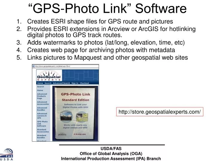
“GPS-Photo Link” Software. Creates ESRI shape files for GPS route and pictures Provides ESRI extensions in Arcview or ArcGIS for hotlinking digital photos to GPS track routes. Adds watermarks to photos (lat/long, elevation, time, etc) Creates web page for archiving photos with metadata

E N D
“GPS-Photo Link” Software • Creates ESRI shape files for GPS route and pictures • Provides ESRI extensions in Arcview or ArcGIS for hotlinking digital photos to GPS track routes. • Adds watermarks to photos (lat/long, elevation, time, etc) • Creates web page for archiving photos with metadata • Links pictures to Mapquest and other geospatial web sites http://store.geospatialexperts.com/ USDA/FASOffice of Global Analysis (OGA)International Production Assessment (IPA) Branch
Ethiopia Crop Assessment Tour (1800+ photos) July 14-August 2, 2006 USDA/FASOffice of Global Analysis (OGA)International Production Assessment (IPA) Branch
Creates ESRI shape files (route & picture) and provides ESRI extensions for displaying photos USDA/FASOffice of Global Analysis (OGA)International Production Assessment (IPA) Branch
Links to Photos to Google Maps and MapQuest USDA/FASOffice of Global Analysis (OGA)International Production Assessment (IPA) Branch
Elevation data is useful USDA/FASOffice of Global Analysis (OGA)International Production Assessment (IPA) Branch
WRSI Anomaly(Relative Yield) (Feb 2nd dekad, 2005 Compared to Past 8-year Average) WRSI Anomaly(Relative Yield)(Feb 3rd dekad 2004 Compared to Past 7-year Average) Crop tourconfirmed localized areas with crop failures. Crop tour confirmed excellent crop conditions throughout entire corn-belt region. WRSI Anomaly Model (Relative Yield )(2004 and 2005 Comparison) USDA/FASOffice of Global Analysis (OGA)International Production Assessment (IPA) Branch WRSI Anomaly Relative yield model from FEWS/USGS at http://igskmncnwb015.cr.usgs.gov/adds/
WRSI Relative Yield (2003/04) WRSI Relative Yield (2004/05) Albertshoek (Crop failure May 2004, butbumper harvest May 2005) Feb. 24, 2004 Feb. 22, 2005 Crop failure in 2004 Average to above-average crop in 2005 USDA/FASOffice of Global Analysis (OGA)International Production Assessment (IPA) Branch • GPS and digital camera data integrated with relative-yield model.
Feb. 3rd dekad, 2004 Feb. 2nd dekad,2005 Near-average crop for both years Average to above-average crop this year Viljoennskroon (Standing from same point--on top of an overpass) Feb 24 2004 Feb 22, 2005 USDA/FASOffice of Global Analysis (OGA)International Production Assessment (IPA) Branch • GPS and digital camera data integrated with relative-yield model.
FEWS national offices have the potential to document numerous trips paid by US tax payers 1800+ photos1000+ photos1400+ photos~400 photos~500 photos USDA/FASOffice of Global Analysis (OGA)International Production Assessment (IPA) Branch