Download
1 / 21
210 likes | 335 Views
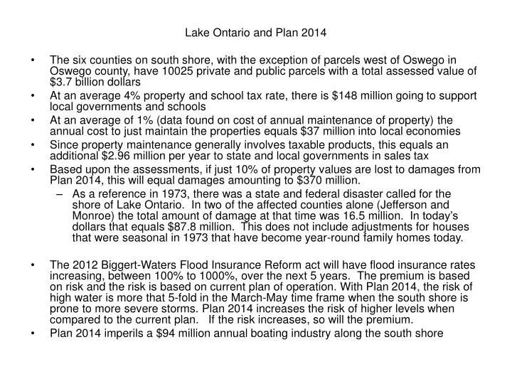
Lake Ontario and Plan 2014 The six counties on south shore, with the exception of parcels west of Oswego in Oswego county, have 10025 private and public parcels with a total assessed value of $3.7 billion dollars

E N D
Lake Ontario and Plan 2014 • The six counties on south shore, with the exception of parcels west of Oswego in Oswego county, have 10025 private and public parcels with a total assessed value of $3.7 billion dollars • At an average 4% property and school tax rate, there is $148 million going to support local governments and schools • At an average of 1% (data found on cost of annual maintenance of property) the annual cost to just maintain the properties equals $37 million into local economies • Since property maintenance generally involves taxable products, this equals an additional $2.96 million per year to state and local governments in sales tax • Based upon the assessments, if just 10% of property values are lost to damages from Plan 2014, this will equal damages amounting to $370 million. • As a reference in 1973, there was a state and federal disaster called for the shore of Lake Ontario. In two of the affected counties alone (Jefferson and Monroe) the total amount of damage at that time was 16.5 million. In today’s dollars that equals $87.8 million. This does not include adjustments for houses that were seasonal in 1973 that have become year-round family homes today. • The 2012 Biggert-Waters Flood Insurance Reform act will have flood insurance rates increasing, between 100% to 1000%, over the next 5 years. The premium is based on risk and the risk is based on current plan of operation. With Plan 2014, the risk of high water is more that 5-fold in the March-May time frame when the south shore is prone to more severe storms. Plan 2014 increases the risk of higher levels when compared to the current plan. If the risk increases, so will the premium. • Plan 2014 imperils a $94 million annual boating industry along the south shore
Points Regarding Plan 2014 • The proposed plan 2014 is not one of the recommended plans from the 2006 IJC Study and it violates three of the principle guidelines of the IJC Study. • •The Plan 2014 analyses are based upon outdated and incorrect assumptions and data. • •Trigger levels and deviations provided in Plan 2014 will not protect from extreme levels on Lake Ontario. • •For over fifty years, individuals, businesses and municipalities have relied upon the commitment to target Lake Ontario within the four-foot range in the design and construction of shore protection, public and private marine facilities and public infrastructure. • Government should honor its commitment.
The proposed plan 2014 is not one of the recommended plans from the 2006 IJC Study. It is far more radical in its damages to the Lake Ontario shoreline communities with little additional benefit to the environment. • •The 2006 IJC Study recommended consideration of three plans: • –Plan A+ - “ The Economic Plan” • –Plan B+ - “The Environmental Plan” • –Plan D+ - “The Balanced Plan”
In 2008, the IJC decided to propose Plan D+, the Balanced Plan, renamed it Plan 2007, and stated: • “Plan 2007 is an improvement with respect to environmental and overall economic benefits, and takes a more balanced approach to all interests.” • In 2008, the IJC also stated that the environmental benefits of Plan B+ are desirable, but implementation of Plan B+ is not possible “without unduly reducing the benefits and protections currently accorded to other interests.” • •Secret, closed door negotiations since 2009 produced Plan Bv7 (2011) and Plan 2014 (2013).
Plan 2014 explicitly violates three of the principle guidelines of the IJC Study. • (a) No plan should be implemented that results in a disproportionate loss to any one user group or geographic area. • –Plan 2014 concentrates damages in the south shore communities of Wayne, Cayuga, Monroe, Orleans and Niagara Counties with little to no damage elsewhere. • (b) No plan be adopted which results in damages without appropriate mitigation and compensation in place prior to implementation. • - No mitigation or compensation is proposed or planned. • (c) Plan development will be transparent with broad stakeholder and public input. • –Plan 2014, and its preceding Plan BV7, were developed by a secret Working Group, meeting in secret, with access and input only from environmental advocates.
The Plan 2014 analyses are based upon outdated and incorrect assumptions and data collected over ten years ago during the 2006 study. • •Study Board Minority Report (2007) pointed out numerous problems with study. • •National Research Council/Royal Society Review stated that environmental and coastal processes analyses should not be relied upon for decision-making. • •Since then, only environmental work has been done to attempt to address the deficiencies. • •A recent NYS DEC limited attempt to look at the coastal damage assessment data was inconclusive. Nothing else has been done. • •The DEC now states that at least 5 public water supply or sanitary sewer systems would be threatened by Plan 2014. No damages for this are included in the economic analysis.
Trigger levels and deviations provided in Plan 2014 will not protect from extreme levels on Lake Ontario • •Under the Plan 2014 proposal, routine deviations from the plan will be allowed for all interests except for those affected by Lake level. • •Deviations for Lake allowed only when trigger levels are exceeded and only after getting Commission approval. • •From proposed Deviation Directive: • –“If the Board expects that lake levels will be outside the range defined by the trigger levels, then … the Board will request permission from the Commission to make a major deviation from the plan once the trigger level is reached to moderate the extreme levels.” • •In this step, Adaptive Management is being abandoned – It now exists and has been practiced with the current plan and Order through the deviations by the Board.
For over fifty years, users have relied upon the commitment to target Lake Ontario within the four-foot • •From the Existing Order (criterion (g)) • “Consistent with other requirements, the levels of Lake Ontario shall be regulated … so as to reduce the extremes of stage which have been experienced.” • •Even now, the St. Lawrence River Board of Control Web site states (FAQ’s): • “The Board encourages everyone to be aware of water levels and to be prepared to live within the range of levels specified in the Orders of Approval. For Lake Ontario, the upper limit for monthly mean levels is 75.37 m (247.3 ft) and the lower limit (from April to December) is 74.15 m (243.3 ft), a range of 1.22 m (4 ft).”
For over fifty years, users have relied upon the commitment to target Lake Ontario within the four-foot. • •Regulatory mean high and low water elevations set at the upper and lower ends of the existing four foot range. • •Engineering design of boat launches, public and private docks, public infrastructure as well as private shore protection forced by State and Federal authorities to use these limits in design. • •Millions of dollars in retro-fits will be required with Plan 2014. • –Where is the mitigation and compensation for this? • –Who pays? • –Why are these costs not included in the economic projections presented for Plan 2014?
Government should honor its Commitment • •Plan 2014 betrays the trust in the IJC to do the right thing and balance the benefits of the system. • •Costs for Plan 2014 will fall to the least powerful segments of the system in a small geographic area – individual property owners and small businesses on the Lake south shore. • •All other interests/areas will gain or be held harmless. • •Plan 2014 betrays the commitment made when the project was approved and built.
Water level/s at Sodus Point Sodus Point Village Flood Level 1:20 yrs. 5X 3X
Water level/s at Sodus Point low water • Increase in blue-green algae bloom • Release of significant high toxins • Shorter season for marinas & loss of revenue • More groundings & increased requirements for dredging • Major loss in Tourism • Decrease in tax revenue
Water level/s at Sodus Point HIGH WATER • Shut down the water system • Shut down of wastewater treatment plant • Condemned properties • Effluents going into the Bay • and Lake
Water level/s at Sodus Point HIGH WATER • Property Damage • Decrease in Property value • Street flooded • Sanitary sewers overflowing • Sanitary sewer lift stations inoperable