Download
1 / 8
80 likes | 87 Views
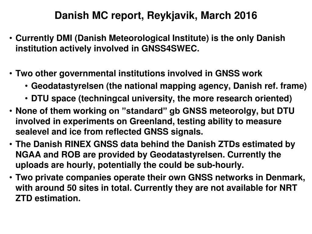
Danish MC report, Reykjavik, March 2016. Currently DMI (Danish Meteorological Institute ) is the only Danish institution actively involved in GNSS4SWEC. Two other governmental institutions involved in GNSS work Geodatastyrelsen (the national mapping agency , Danish ref. frame)

E N D
Danish MC report, Reykjavik, March 2016 Currently DMI (Danish MeteorologicalInstitute) is the only Danish institution activelyinvolved in GNSS4SWEC. Twoothergovernmental institutions involved in GNSS work Geodatastyrelsen (the national mappingagency, Danish ref. frame) DTU space (techningcaluniversity, the more research oriented) None of themworking on ”standard” gb GNSS meteorolgy, but DTU involved in experiments on Greenland, testingability to measure sealevel and ice from reflected GNSS signals. The Danish RINEX GNSS data behind the Danish ZTDsestimated by NGAA and ROB areprovided by Geodatastyrelsen. Currently the uploadsarehourly, potentially the couldbe sub-hourly. Two private companiesoperatetheirown GNSS networks in Denmark, with around 50 sites in total. Currentlytheyare not available for NRT ZTD estimation.
Not muchdedicated gb GNSS meteorologyrelated DMI work at DMI in 2015, except for writingproposals.. Mainlybecauseour most important data source, NGAA, has been under reconstruction. It is now back in operation. Plan to workdedicated on assimilation of ZTD in 2016, in models with the resolution of 2.5 and 1 km. The density of sites versus impactwillbeonefocusarea. The use of ”fast processed” relative to hourly ZTD productpossiblyanother.
GNSS radio occultation at DMI DMI is heading the EUMETSAT ”ROMSAF”, involved in processing GNSS RO data from the EUMETSAT METOP polar satellite. These data areprocessedboth for usage in operational NWP and climatemonitoring. GNSS RO data have becomeveryimportant for operational NWP, in particular for the global models. DMI is preparing to assimilate GNSS RO data in our regional HARMONIE, 2.5 km, NWP model. The observation operator for thatalreadyexists in HARMONIE. DMI climate DMI previouslystudyingoutcome of climate simulations to asssess the usefulness of GNSS measures, likerefractivity profiles (from RO) and ZTD for climatemonitoring, but no recent work. Plans for startinghigh resolution re-analysisproject, in collaboration with othermet services. Re-processed gn GNSS ZTD/IWV couldbe an importantvalidation source. Probably not flying in 2016 though.
On E-GVAP (EUMETNET EIG GNSS Water Vapour Programme) E-GVAP team: Henrik Vedel (DMI), Siebren de Haan (KNMI) Jonathan Jones, Gemma Bennitt, Dave Offiler (UKMO) E-GVAP coordinates near real time processing of gb GNSS data to estimate ZTD and distribute those in near real-time for usage in operational meteorology. E-GVAP is based on a collaboration between geodesy and meteorology, involving 18+ GNSS analysis centres, 16 national European metofficies, and ties to NOAA/NCEP, Environment Canada and the met office of South Korea.
Collaboration with the met office of South Korea. Data exchange to start SuomiNetwork additional sites in the US. Only available via institute specific download – not yet E-GVAP
The research done in GNSS4SWEC is extremely important to progress in gb GNSS meteorology, and hence to E-GVAP members. E-GVAP has infrastructure that may help us exchange data in GNSS4SWEC. E-GVAP provides meteorological data for validation of GNSS tropospheric estimates. Notice that ZTD data uploaded to E-GVAP are automatically monitored against the UK Metoffice global NWP model. E-GVAP (and all other EUMETNET programmes) to be ”renewed” by end of 2017. Preparations for that will start summer/autumn 2016.