Download
1 / 24
240 likes | 546 Views
Regulations and Processes for Floodway/Non-Encroachment Area Encroachments. What to look for and what to require. Robert Billings, PE, PH, CFM Mecklenburg County Storm Water Services November 15, 2008 NCAFPM Fall Floodplain Institute Asheville, NC. Overview of Presentation.

E N D
Regulations and Processes for Floodway/Non-Encroachment Area Encroachments. What to look for and what to require. Robert Billings, PE, PH, CFM Mecklenburg County Storm Water Services November 15, 2008 NCAFPM Fall Floodplain Institute Asheville, NC
Overview of Presentation • This presentation is based on the 44 CFR Sections 50-79. These sections define the NFIP program. All participating NFIP communities in North Carolina are required to implement the minimum standards defined in the code. • Local community standards may be more stringent than the minimum FEMA standards presented.
“No-Impact” Studies Why do I need to worry about the “No-Impact” study – the engineer said the impact was essentially zero?
So, just what is a No-Impact Study? A No-Impact study or certificate is a summary of calculations, geographic information, and engineering judgments documenting impacts to water surface elevations from development in a defined floodway. 44 CFR Section 60.3 (d) (3) Prohibit encroachments, including fill, new construction, substantial improvements, and other development within the adopted regulatory floodway unless it has been demonstrated through hydrologic and hydraulic analyses performed in accordance with standard engineering practice that the proposed encroachment would not result in any increase in flood levels within the community during the occurrence of the base flood discharge;
Draft State Guidelines • Characteristics of a No-Impact study… • No increase in BFE as a result of the project • If there is a decrease of less than 0.1’, no additional action is required. • If there is a decrease of more than 0.1’, a LOMR will be necessary to correct the maps • Of course, is there is an increase you must follow the CLOMR/LOMR path
Your Role in “No-Impact” Studies Property Owners Engineers Developers Your Boss North Carolina Certified Floodplain Manager FEMA Commissioners, Council Members, Home owner associations
Your Role in “No-Impact” Studies • Your Role as your communities Floodplain Administrator, in the “No-Impact” Study Process… Protection of your Community Communication with Stakeholders
Your Role in “No-Impact” Studies As your communities Floodplain Administrator, you should be prepared to answer general “No-Impact” questions. Community officials will look to you for logical and understandable answers to complex questions. • What is a “No-Impact” study? • What is a Manning’s “n” value? • Do we need a CLOMR/LOMR from FEMA if we have a “No-Impact” study?
“No-Impact” Studies When is a “No-Impact” study required? Let’s look a little closer at 44 CFR section 60.3 (d): (3) Prohibit encroachments, including fill, new construction, substantial improvements, and other development within the adopted regulatory floodway …
Encroachments Is the Proposed Subdivision an encroachment? It is an encroachment into the flood fringe – a “No-Impact” study is not required.
Encroachments Is the Proposed Greenway an encroachment? It is an encroachment into the flood fringe and floodway. If the project will be constructed on grade (no fill), a “No-Impact” study may not be required.
Encroachments Is the Proposed Lot an encroachment? Is the New Home? The proposed lot is an encroachment into the floodway. If the project will be constructed on grade (no fill), a “No-Impact” study would not show any changes and may not be required.
Encroachments Is the Proposed Subdivision an encroachment? The proposed lots and structures in the floodway are encroachments. A “No-Impact” study showing a 0.00’ increase (or less) would be a minimum requirement for this situation.
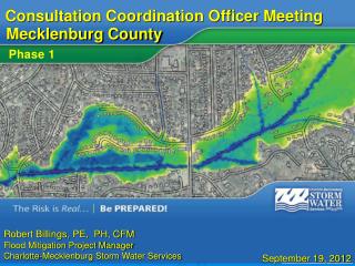
Phase 1 – I have to do what? “Your proposed building is encroaching in my non-encroachment area. To build this project, you must submit either a No-Impact Study or a CLOMR.” “Okay...???? I understand completely… what do I need to do?”
Phase 2 – Find a flood study person. “Our proposed building is encroaching in the encroaching area. We need a flood/LOMaR/encroaching study, and we need it yesterday.” “Okay...???? I understand completely… what do I need to do?”
Phase 3 – Communicate with the flood study person. • Water surface profiles are computed from one cross section to the next by solving the Energy equation with an iterative procedure called the standard step method. • WS2 + α2V22 =WS1 + α1V12 + he • 2g 2g “Okay, I understand Completely…Now this is what I want to see in your study…”
Phase 4 – The Study. • “Include a detailed narrative.” • State that you have followed our local ordinance, state statutes and guidelines and NFIP guidelines. • State that your study was developed using standard engineering practices. • State all assumptions and engineering judgments. • If you are developing a No-Impact study…state the results in simple English: The proposed project will have a 0.00’ increase on the Base Flood Elevation.
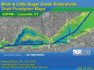
Phase 4 – The Study. • “Include supporting information.” • Include a map showing the general vicinity of the project. • Include a map showing your HEC-RAS Cross-Sections. • Include photos or documentation supporting your Manning’s “n” values. • Include a table showing Water Surface Elevations for your proposed conditions and existing conditions. • Here are a few examples…
Phase 4 – Close the deal. Thank you so much for your guidance. You are truly a great and wonderful Floodplain Administrator. “My work here is Complete.”
Communication between the Floodplain Administrator and the food study person is essential to the success of your project and your program.