Download
1 / 37
370 likes | 515 Views
Western Region Space Grant Conference-Reno September 19, 2009. Program Objectives. Satellite Calibration and Validation Provide platforms to enable essential calibration measurements for the Earth observing satellites, and the validation of data retrieval algorithms. New Sensor Development

E N D
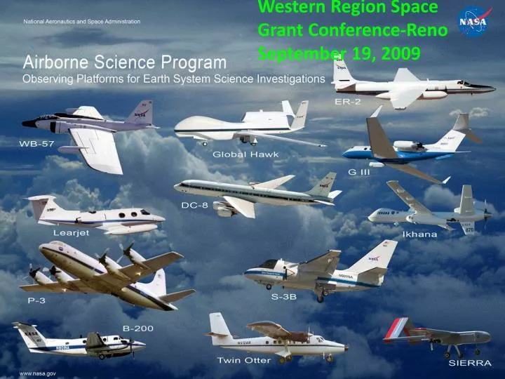
Western Region Space Grant Conference-Reno September 19, 2009
Program Objectives Satellite Calibration and Validation Provide platforms to enable essential calibration measurements for the Earth observing satellites, and the validation of data retrieval algorithms. New Sensor Development Provide sub-orbital flight opportunities to test and refine new instrument technologies/algorithms, and reduce risk prior to committing sensors for launch into space. Process Studies Obtain high-resolution temporal and spatial measurements of complex local processes, which can be coupled to global satellite observations for a better understanding of the complete Earth system. Development of Next-Generation Scientists and Engineers Foster the development of our future workforce with the hands-on involvement of graduate students, and young scientists/engineers in all aspects of ongoing Earth science investigations.
NASA-NSERC StudentAirborne Research Program(SARP) July-August 2009 George Seielstad Rick Shetter Alexandra Novak
SARP’s Objectives • Inspire students to pursue STEM disciplines. • Develop next generation of Earth System Scientists—with fresh research ideas. • Demonstrate integration of science, engineering, and operations in major missions. • Expose students to NASA programs.
Students’ Institutions • U Puerto Rico • Montclair State U • Rutgers U • U Michigan • Howard U • Coastal Carolina U • U Florida • Loyola Marymount • Slippery Rock U • Carleton College • U of Alaska Anchorage • Randolph College • U Iowa • Montana State U • UC Irvine • Wellesley College • Georgia Tech • Michigan Tech U • South Dakota School of Mines and Technology • U North Dakota • Brown U • Texas A&M U • Arizona State U • U Maryland • UC Santa Cruz
Students’ Concentrations • Physics • Chemistry • Geoscience • Environmental Science • Engineering: Mechanical, Chemical, Aerospace, Agriculture, Civil • Atmospheric Sciences • Marine Biology • Meteorology • Telecommunications
SARP’s Strength: Students 29 Students, diverse in many respects
Faculty UC Irvine: Don Blake, Sherwood Rowland (chemistry) Monterey Bay Aquarium Research Institute: John Ryan (oceanography) UC Davis: Susan Ustin (agriculture) Florida State U: Henry Fuelberg (meteorology) U Iowa: Greg Carmichael (modeling) NASA: Jeff Myers, Andy Roberts, Jack Kaye, Brenda Mulac, Marilyn Vasques, Ken Jucks, Jim Crawford, Barbara Schoeberl
Faculty Commitment Learning from each other (Nobel Prize notwithstanding)
Melissa Yang Nick Clinton Shawn Kefauver Mentors Crucial Strengths of SARP Fully committed to students Extremely knowledgeable Constantly accessible Guidance, not spoon-feeding Personable
End-to-End Mission • Classroom—lectures for context (See http://www.nserc.und.edu/learning/SARPmm.html) • Hangar—flight planning • Aircraft—data acquisition • Field—surface validation • Laboratory—data analysis & interpretation • Classroom—Student presentations
Projects • Evapotranspiration in Almond Orchard and Cotton Field, CA Central Valley • Air Quality, CA Central Valley • Algal Bloom, Monterey Bay, CA
Evapotranspiration • Continuing drought and additional competing uses make water California’s most precious resource. • Allocation for irrigation—in US’s most productive ag region—sharply reduced. • Irrigation demand driven by water crops transpire.
Satellite Air Ground Almond Orchard System Integration Objective
Satellite Drip irrigation Fanjet irrigation COMPARISON
ET from MASTER & Model ET from ground data 1.110 mm/hr 1.078 mm/hr 1.064 mm/hr 1.074 mm/hr 1.081 mm/hr 1.056 mm/hr 1.053 mm/hr
Presentation of Results Students’ Conclusions, ET • Fanjet irrigation more effective than drip irrigation, leading to higher ET. • METRIC model underestimates ET compared to the CIMIS PM equation.
Monterey Bay Features MASTER Enhanced image (Square root: linear 2%)
Conclusions, Monterey Bay Hypothesis rejected: inconsistency in scaling between model and observed features. Unlikely cause: inconsistency in orientation of observed features. No significant difference in between features. No definitive cause of features. Apparently wind-driven, possibly linked to supercritical atmospheric waves. Features not exclusively an atmospheric phenomenon.
Central Valley, CA Dairies • First in U.S. milk production (2006) • 2.5 million cows in San Joaquin Valley • A main source of VOCs and fine particulates. (SJV Air Pollution Control District, Aug. 2005)
Air (WAS) Ground Lab Data Acquisition
Chromatograph Results Propanol Ethanol 25
Conclusions: Air Quality Silage piles contributing oxygenates to Central Valley Air Basin Methanol and ethanol concentrations from dairy perimeter consistent with concentrations in boundary layer. Grid study shows existence of even higher emissions than our case study’s.
Future 6-Week Program • 1 week for lectures, limits per topic • 1 week at DAOF for instrument integration, flight planning. • 1 week of data acquisition from DAOF. • 2 flights if DC-8; 3 flights if fewer seats on aircraft. • 3 days per project for surface measurements • 2.5 weeks for data analysis • 0.5 weeks for presentations
NASA Dryden Flight Research Center Education Flight Projects Airborne Research Experiences for Educators (AREE) - An airborne research and curriculum development experience for 10 (ten) middle and high school educators using the NASA DC-8 aircraft • Outcome: To develop curriculum-based activities relating to NASA airborne research and Earth system science • Educational goals mapped to NASA Education Strategic Coordination Framework, 2006 to inspire, engage, educate, and employ the future aerospace workforce • Target Group: Ten (10) secondary educators (grades 6-12) who specialize in Science, Technology, Engineering, or Math (STEM) disciplines • Committed partnerships between Dryden FRC, Cal State Fullerton, NSERC, Johnson Space Center, UC Irvine and AEROI AREE educator home locations by state
AREE Project Outcomes • Educators participated in an airborne and ground research campaign to learn how NASA uses airborne research to study Earth system science. • 10 new curriculum units that engage students in the question “How does data gathered through NASA airborne research campaigns help us understand interactions between Earth systems?” • 10 highly inspired AREE Master Teachers prepared and motivated to engage and educate high school students to pursue STEM and NASA-related careers through AREE curriculum units. • 1500 middle and high school students motivated to achieve in math and science through inquiry- based investigations of NASA airborne research data. Students and educators participated in airborne research aboard the NASA DC-8 aircraft
AREE Future Projects Using NASA Airborne Science Program (ASP) Flight platforms to provide K-12 educators with the skills and knowledge to attract and retain students in STEM disciplines. • Other AREE education flight projects will look to engage participants in airborne research aboard other ASP flight platforms including the DC-8, P-3B, and Global Hawk • Developed AREE-extension programs will include pre- and in-service educators in summer workshops relating to NASA AREE-related outcomes • To include a global climate change research and professional development experience • A web-based Virtual Control Room Network highlighting ASP research campaigns • Development of a professional online learning community and web-based platform to disseminate AREE-related curriculum • Subsequent programs for K-12 students and higher education
Airborne Research Experiences for Educators (AREE) An airborne research and curriculum development experience for 10 (ten) middle and high school educators using the NASA DC-8 aircraft Thermal Infrared image NASA AREE-related curriculum will engage ~1500 middle and high school students across the country in Earth system sciences in its inaugural year Images collected from the MASTER instrument during the DC-8 SARP-AREE flight Wednesday July 22, 2009 DC -8 Flight Path Flight Path The MASTER instrument was used to collect remote sensing data of algal blooms at Monterey Bay , CA from ~37,000 ft. AGL MASTER (MODIS/ASTER) instrument Visible Near Infrared image Investigationsinvites students to engage in inquiry-based activities. Find Out More invites students to review related NASA resources. Images will engage K-12 students in the differences between visible and infrared spectral bands in the electromagnetic spectrum. NASA DC-8 aircraft flying above Dryden Aircraft Operations Facility in California
Airborne Research Experiences for Educators (AREE) Educators participated in an airborne and ground research campaign to learn how NASA uses airborne research to study Earth system science. Educators incorporated these concepts into their middle and high school curriculum Atmospheric science team Educators collected in situ dairy farm gas emissions over the Central Valley via the Whole Air Sampler from ~1000 ft. AGL Air samples were analyzed in the laboratory and the results were incorporated into middle and high school curriculum modules Algal Bloom team Rachael Fein (far left) will simulate airborne and ground data collection to her 9th and 10th grade mathematics and robotics students using LEGO robots Crop Classification team Educators participated in collecting in situ data from a boat in Monterey Bay, CA for algal bloom research. Crop Classification team The MASTER instrument was used to measure evapotranspiration of crops (i.e. cotton fields and almond orchards) from ~13,000 ft AGL Based on his airborne and ground research experience, educator Terry Nickerson incorporated the concepts of remote sensing and color to study vegetation into his Earth Science and Biology high school curriculum
Wetland Education using Maps, Aerial Photography, and Satellite Imagery Catherine M. Lockwood Lawrence R. Handley Nathan Handley Chadron State College USGS National Wetlands IT Consultant Chadron, Nebraska Research Center Lafayette, Louisiana Lafayette, Louisiana
Primary Goal To teach basic map skills and imagery interpretation using Wetlands as the focal point. Secondary Goal To introduce multiple maps and images to educators. WETMAAP
Program Facts 1996-2008 Sites in 16 states, the District of Columbia, Costa Rica and Panama Total Training Sessions: 157 Total Participants: 3,828 Average per session: 24.50 Workshops and Participants1996-2008
Summary • Education is a substantial part of ASP • There are positive results • There is senior management support • This will continue