Download
1 / 1
0 likes | 11 Views
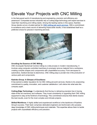
Unlock the power of precision and efficiency in your<br>projects with NV5's cutting-edge Aerial<br>Photogrammetry services. As a leader in innovative<br>solutions, NV5 leverages advanced technology to<br>provide unparalleled accuracy and detailed insights<br>from above.<br>

E N D
ELEVATE YOUR PROJECTS WITH NV5'S AERIAL PHOTOGRAMMETRY SOLUTIONS Unlock the power of precision and efficiency in your projects with NV5's cutting-edge Aerial Photogrammetry services. As a leader in innovative solutions, NV5 leverages advanced technology to provide unparalleled accuracy and detailed insights from above. Our Aerial Photogrammetry services utilize state-of- the-art unmanned aerial vehicles (UAVs) equipped with high-resolution cameras and LiDAR sensors. This allows us to capture detailed imagery and elevation data, enabling a comprehensive 3D mapping of your project site. The result is a precise and detailed representation that enhances decision-making and project planning. NV5's team of skilled professionals combines expertise in geospatial analysis, remote sensing, and photogrammetric techniques to deliver reliable and actionable data. Whether you're in urban planning, construction, environmental monitoring, or infrastructure development, our Aerial Photogrammetry solutions empower you with the insights needed for success. Experience the benefits of streamlined workflows, reduced project timelines, and enhanced decision support by choosing NV5 for your Aerial Photogrammetry needs. Elevate your projects to new heights with NV5's commitment to excellence and innovation in geospatial solutions. www.nv5.com