Download
1 / 1
0 likes | 5 Views
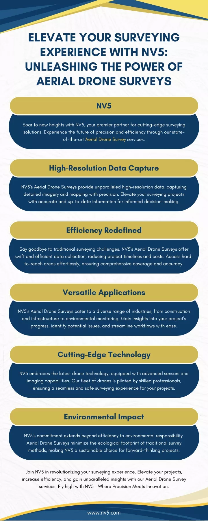
Soar to new heights with NV5, your premier partner for cutting-edge surveying<br>solutions. Experience the future of precision and efficiency through our stateof-the-art Aerial Drone Survey services.<br>

E N D
ELEVATE YOUR SURVEYING EXPERIENCE WITH NV5: UNLEASHING THE POWER OF AERIAL DRONE SURVEYS NV5 Soar to new heights with NV5, your premier partner for cutting-edge surveying solutions. Experience the future of precision and efficiency through our state- of-the-art Aerial Drone Survey services. High-Resolution Data Capture NV5's Aerial Drone Surveys provide unparalleled high-resolution data, capturing detailed imagery and mapping with precision. Elevate your surveying projects with accurate and up-to-date information for informed decision-making. Efficiency Redefined Say goodbye to traditional surveying challenges. NV5's Aerial Drone Surveys offer swift and efficient data collection, reducing project timelines and costs. Access hard- to-reach areas effortlessly, ensuring comprehensive coverage and accuracy. Versatile Applications NV5's Aerial Drone Surveys cater to a diverse range of industries, from construction and infrastructure to environmental monitoring. Gain insights into your project's progress, identify potential issues, and streamline workflows with ease. Cutting-Edge Technology NV5 embraces the latest drone technology, equipped with advanced sensors and imaging capabilities. Our fleet of drones is piloted by skilled professionals, ensuring a seamless and safe surveying experience for your projects. Environmental Impact NV5's commitment extends beyond efficiency to environmental responsibility. Aerial Drone Surveys minimize the ecological footprint of traditional survey methods, making NV5 a sustainable choice for forward-thinking projects. Join NV5 in revolutionizing your surveying experience. Elevate your projects, increase efficiency, and gain unparalleled insights with our Aerial Drone Survey services. Fly high with NV5 – Where Precision Meets Innovation. www.nv5.com