Download
1 / 1
0 likes | 13 Views
Efficiency: Cover large areas quickly, making large-scale projects more feasible.<br>

E N D
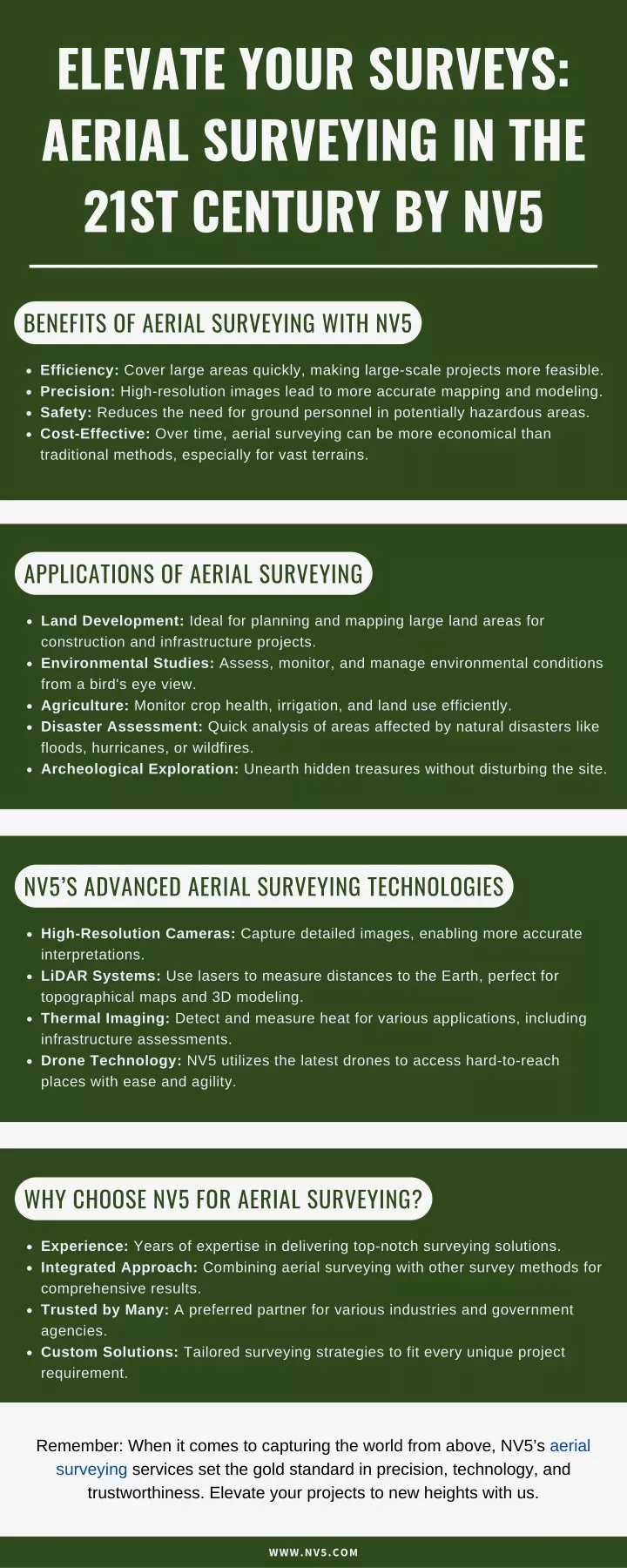
ELEVATE YOUR SURVEYS: AERIAL SURVEYING IN THE 21ST CENTURY BY NV5 BENEFITS OF AERIAL SURVEYING WITH NV5 Efficiency: Cover large areas quickly, making large-scale projects more feasible. Precision: High-resolution images lead to more accurate mapping and modeling. Safety: Reduces the need for ground personnel in potentially hazardous areas. Cost-Effective: Over time, aerial surveying can be more economical than traditional methods, especially for vast terrains. APPLICATIONS OF AERIAL SURVEYING Land Development: Ideal for planning and mapping large land areas for construction and infrastructure projects. Environmental Studies: Assess, monitor, and manage environmental conditions from a bird's eye view. Agriculture: Monitor crop health, irrigation, and land use efficiently. Disaster Assessment: Quick analysis of areas affected by natural disasters like floods, hurricanes, or wildfires. Archeological Exploration: Unearth hidden treasures without disturbing the site. NV5’S ADVANCED AERIAL SURVEYING TECHNOLOGIES High-Resolution Cameras: Capture detailed images, enabling more accurate interpretations. LiDAR Systems: Use lasers to measure distances to the Earth, perfect for topographical maps and 3D modeling. Thermal Imaging: Detect and measure heat for various applications, including infrastructure assessments. Drone Technology: NV5 utilizes the latest drones to access hard-to-reach places with ease and agility. WHY CHOOSE NV5 FOR AERIAL SURVEYING? Experience: Years of expertise in delivering top-notch surveying solutions. Integrated Approach: Combining aerial surveying with other survey methods for comprehensive results. Trusted by Many: A preferred partner for various industries and government agencies. Custom Solutions: Tailored surveying strategies to fit every unique project requirement. Remember: When it comes to capturing the world from above, NV5’s aerial surveying services set the gold standard in precision, technology, and trustworthiness. Elevate your projects to new heights with us. WWW.NV5.COM