Download
1 / 40
400 likes | 521 Views
by the IGOS Cryosphere Theme team (presented by Vladimir Ryabinin, WCRP). Earth observation coordination mechanisms. Integrated Global Observing Strategy-Partnership (IGOS-P), 13 international and UN organizations;

E N D
by the IGOS Cryosphere Theme team (presented by Vladimir Ryabinin, WCRP)
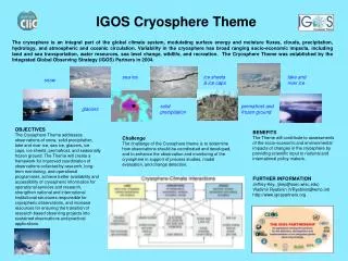
Earth observation coordination mechanisms • Integrated Global Observing Strategy-Partnership (IGOS-P), 13 international and UN organizations; • Committee on Earth Observation Satellites (CEOS), 44 space agencies and Earth observation data users operating more than 100 satellites; • Group on Earth Observations (GEO) and the Global Earth Observing System of Systems (GEOSS)
Integrated Global Observing Strategy (IGOS) Partnership UN Organisations Committee on Earth Observing Satellites WMO International science support and coordination programs Global Observing Systems
Integrated Global Observing Strategy (IGOS) Themes APPROVED GEOHAZARDS OCEANS WATER CARBON COASTAL Atm. Chem. UNDER DEVELOPMENT CRYOSPHERE LAND COVER GEODESY CONSIDERED HEALTH
What is an IGOS Theme all about? • An idea for IGOS-P to consider covering an important domain in Earth observations • Preparation of Report (analysis of requirements, identification of gaps, search for solutions, working out recommendations, identification of needed actions, preparation of implementation timeline) • Review by the community • Approved Report • Implementation • The IGOS Theme on Cryosphere goes beyond climate interests and encompasses ALL cryospheric observations
User-requirement product driven • Has a ~10 year time frame • Goal 1: resources for observations • Goal 2: Stronger commitmentby observing system operators to sustainthe observing system. Cryosphere • is one of the most under-sampled elements within the climate system • is undergoing dramatic changes, mostly as a consequence of climate change, and provides best indicators for it Approved by IGOSP-11, Rome, Italy, 27 May 2004
Ch 2: Applications of Cryospheric Data 2.1. Cryosphere, Weather, and Climate 2.2. Importance of the Cryosphere for Society Disasters Health Energy Climate Water Weather Ecosystems Agriculture Biodiversity + Transport
Dream Team Main authors: Jerry Brown, USA Don Cline, USA Josephino Comiso, USA Claude Duguay, Canada – former IARC Guido Grosse, USA - IARC Ken Jezek, USA Paul Joe, Canada Boele Kuipers, Norway Rob Massom, Australia Walt Meier, USA Frank Paul, Switzerland Helmut Rott, Austria Sharon Smith, Canada Stein Tronstad, Norway Daqing Yang, USA - IARC Tingjun Zhang, USA Leadership: Jeff Key, Chair , USA Mark Drinkwater, Vice-chair, The Netherlands Jinro Ukita, Vice-chair, Japan Vladimir Ryabinin, WCRP/.WMO Marzena Kaczmarska, SCAR Barry Goodison, Canada Victoria Lytle, CliC Don Hinsman (liaison to IGOS), WMO Technical support: Angelique Prick, CliC Contributions from ~ 50 people from 14 countries
We did not start from scratch: Previous IGOS reports GCOS Impl. Plan, Satellite Supplement CEOS response to it IPY documentation including project proposals CliC project plans & documentation Plans of various science and observing programs WMO set of requirements Etc.
developmentwebsite: (designed and run by J. Key) http://igos-cryosphere.org/
Workshops • 1st Workshop, Kananaskis, Canada, 2-4.03.2005, supported by CSA, 22 participants • 2nd Workshop, hosted by JAMSTEC, Yokohama, Japan, 24-25.04.2006, supported by JAXA and JAMSTEC, 36 participants • 3rd Workshop, hosted by ESA, ESTEC, Noordwijk, The Netherlands, 16-18.10. 2006, supported by NOAA and NASA
Report Preface Foreword Executive Summary 1. The Cryosphere Theme 2. Applications of Cryospheric Data 3. Terrestrial Snow 4. Sea Ice 5. Lake and River Ice 6. Ice Sheets 7. Glaciers and Ice Caps 8. Surface Temperature and Albedo of Snow and Ice 9. Permafrost and Seasonally Frozen Ground 10. Solid Precipitation 11. An Integrated and Coordinated Observing System 12. Implementation App. A. References App. B.Observational Capabilities and Requirements App. C. Satellite Missions in Support of the Cryosphere Theme App. D. Acronyms App. E. Contributors App. F. Web Sites for Further Information
Chs 3-10 on cryospheric elements Terrestrial Snow Sea Ice Lake and River Ice Ice Sheets Glaciers and Ice Caps Surface Temperature and Albedo of Snow and Ice Permafrost and Seasonally Frozen Ground Solid Precipitation Short intro: role in Earth system, variability, scales, etc. Status of spaceborne, airborne and in situ observations Shortcomings, gaps, problems Concise element-specificrecommendations
Plan to be developed Perspective missions, needs outlined Specific areas of activities proposed Methodology proposed Most important products identified Ch 3: Terrestrial Snow Intro, status, shortcomings, recommendations: • A plan for surface-based snow-observation networks to be developed: national -> international levelconsistency: observation methods, reporting standards; improved exchange of dataConsiderably improved metadata for snow observations are needed. • The capability of satellite observations to be improved:support of new systems (e.g., E-GPM/CGPM and CloudSat for solid precipitation)support of algorithm developmenthigh-frequency (Ku, X-band) SAR a priority for global SWE • Priority to algorithms and new sensors for SWE under a wide range of vegetation conditions. • Techniques to merge in situ measurements and satellite retrievals:targeted field projects for snow, its albedo and surface temperature in multiple environments, “Super Sites” • Integrated multi-sensor data fusion and global analysis systems that blend snow observations from all sources and produce consistent high-resolution analyses of (at a minimum): 1) the extent of snow cover, 2) snow depth, 3) SWE, and 4) snow wetness using improved algorithms for the objective, optimal combination of snow observations from widely disparate sources, also addressing both mass and energy considerations of snow models.
Ch 11: An Integrated and Coordinated System (1) Satellite remote sensing Ground based observations • SAR • InSAR • PM • Altimetry • Radar Scatterometry • VIS to Thermal IR • Gravity • Ground control • Major Gaps (mostly NPOESS) Airborne observations Modelling, Data Assimilation, Reanalysis
Ch 11: An Integrated and Coordinated System (2) Data and Information Management: Need to have common means toview data, see gaps, combine / overlay data, process data jointly, etc., etc. GIS: Virtual globes by GeoVirtual, Google Earth, NASA World Wind, ESRI ArcGIS Explorer, Skyline's TerraSuite, and many more… Challenge for IGOS Themes, need for a joint approach (GeoVirtual)
Ch 11: An Integrated and Coordinated System (3) Integrated near-real time products: CEOP-like approach More stations Cryo Obs Cryo Models Some stations In-Situ Data Archiving Center at the University Corporation for Atmospheric Researchof USA Model Output Data Archiving Center at the World Data Center for Climate,Max-Planck Institute for Meteorology of Germany Data Integrating/Archiving Center at the University of Tokyo and JAXA of Japan Cryo Products! Joint with IGWCO, built around snow and precip
Ch 11: An Integrated and Coordinated System (4) Related polar observing systems: Southern Ocean CliC, Arctic-HYCOS CLIVAR, CliC, SCAR, … IASC, AOSB, CliC, … Arctic-HYDRA CASO iAOOS
Ch 12: Implementation (1) Many partners (international, regional, national): ~ 30 Cryospheric community of practice Links within IGOS and IGOS Themes:There is no mechanism yet for combining domain–specific requirements for observations and proposing to observing system operators (e.g. satellite agencies) requirements for missions, sensors and their characteristics which would be optimal and acceptable for all Themes Implementation of CryOS as a stand-alone system (a new observing system ??!!) would be nonsensical. Integration of IGOS Themes (with help of GEO?) is needed.
Ch 12: Implementation (2) General recommendation by IGOS-Cryo to IGOS: In-situ and airborne: complementary work of observing stations, platforms, an inventory required (first step – IPY legacy) Space: strengthen inter-agency coordination (one of first steps made by CEOS/GCOS wrt UNFCCC), from virtual to real constellations – GIIPSY, SAR Interoperability, resource sharing: GIS, “virtual globes”, GRID - IPY DIS is heading towards this
Ch 12: Implementation (3) Phases: 1: 2007-2009, IPY 2: 2010-2015 3: After 2015 Governance: 1: Initial stage: WCRP/SCAR, together with reps of GEO and IPY SCObs 2: Built on IPY legacy, also in terms of governance – office and resources to be identified
Way forward Open review: from now to 15 January 2007 – please contribute! Incorporation of results: second half of January Submission to CEOS SIT and IGOS – March, April 2007 Approval expected at the end of May 2007 Printing: June 2007 Implementation: elements are already starting
Improved coverage of cryospheric elements in the GCOS Implementation Plan (autumn 2004) – at the Theme initial phase Contribution to GCOS-CEOS work on satellite-based products for UNFCCC (2006) Work with GEO, GCOS SC, OOPC, GTOS – increased awareness Activity Recommendations for GEO 2006-07 Work Plan Contributions to IPY planning (multiple projects) Support to CryoSat-2, re-launch 2009 Impact on ESA Earth Observation Programme: CoreH2O (snow hydrology) mission, possibility of secondary cryospheric objective on BIOMASS mission Team strengthening, awareness developing, community forming Already achieved Impact of the Cryosphere Theme
Ch 3: Terrestrial Snow Intro, status, shortcomings, recommendations: • A plan for surface-based snow-observation networks to be developed: national -> international levelconsistency: observation methods, reporting standards; improved exchange of dataConsiderably improved metadata for snow observations are needed. • The capability of satellite observations to be improved:support of new systems (e.g., E-GPM/CGPM and CloudSat for solid precipitation)support of algorithm development high-frequency (Ku, X-band) SAR a priority for global SWE • Priority to algorithms and new sensors for SWE under a wide range of vegetation conditions. • Techniques to merge in situ measurements and satellite retrievals:targeted field projects for snow, its albedo and surface temperature in multiple environments, “Super Sites” • Integrated multi-sensor data fusion and global analysis systems that blend snow observations from all sources and produce consistent high-resolution analyses of (at a minimum): 1) the extent of snow cover, 2) snow depth, 3) SWE, and 4) snow wetness using improved algorithms for the objective, optimal combination of snow observations from widely disparate sources, also addressing both mass and energy considerations of snow models.
Ch 4: Sea Ice (1) Intro, status, shortcomings, recommendations: • Continuity of PM, VIS/IR time series • reanalysis / reprocessing PM data to include inter- sensor calibration (using longer overlaps), rigorous evaluation of current algorithms, and development of data fusion methods to obtain optimal combined products. A CDR-quality passive microwave concentration product with error estimates is feasible and should be produced. • Products for snow depth on ice and ice age/type. in collaboration with land snow researchers to develop improved snow estimates over sea ice • Proper coverage by SAR to continue in the Arctic and improvement in Antarctic • Take advantage of dual-polarized SAR sensors to be available soon • Continuity of satellite altimeter missions, coordination between radar and laser altimeter missions to obtain near-coincident data to resolve uncertainties in thickness retrievals • Continuing surface observations, enhanced automatisation, use of mass balance buoys and moored ULS, improved coordination with oceanographic observation programs to leverage ocean buoy deployments, develop combined ARGO buoys for ice measurements as well • Field camps, permission to access waters in national EEZ during the IPY and beyond • Technologies such as UAVs, AUVs, broadband radars with increasing payload (e.g., passive and active microwave on UAVs) • Historical records: data search (ULS, etc.)
Ch 4: Sea Ice (2) Intro, status, shortcomings, recommendations: • There should be coordination with scientists studying ice cores, chemistry, and biology to better integrate physical data with ecosystem studies (e.g., krill, benthic communities). • Development of emissivity and backscatter models will aid in assimilation of remote sensing data in models and may improve retrievals of surface properties. • Satellite-based snow depth products extended to perennial sea ice. Dual frequency SAR sensors may offer new and independent estimates to complement PM techniques. • The continued provision of timely satellite data is critical to allow national ice services to provide comprehensive and detailed ice mapping of the marine cryosphere. Gaps and future operational requirements include: • High-resolution SAR follow-on missions, multiple satellites for revisit and operational redundancy and multi-polarization data for sea-ice classification and (small) iceberg detection. • Sea-ice thickness observations at operational spatial and temporal scales. • Routine data fusion/integration products, e.g., microwave plus optical/thermal (AVHRR/MODIS-type sensors), and radar scatterometer plus a passive-microwave radiometer. This is a non-trivial task, and one that needs to address resolution, coverage and temporal differences between data types. • Quantitative retrievals for model assimilation, requiring validation of algorithms and determination of error characteristics. • The trend towards increasing international cooperation between ice agencies is essential. This includes data access and sharing, and standards in nomenclature, analysis practices and data exchange. • Continued acquisition of Southern Ocean satellite data by, and archiving at, the Arctic and Antarctic Research Center (Scripps) is important. Support to the European PolarView. • Requirements of the ice services to be recognized and met in the long-term strategies.
Ch 5: Lake and River Ice Intro, status, shortcomings, recommendations: • A major data rescue effort for Russia (and other countries) • A set of target regions and lakes/rivers for future long-term ice monitoring must be identified. • Ice observations at largest reservoirs to be reviewed and data exchange considered. • Sites to be reactivated, networks of volunteers encouraged and schools involved like IceWatch in Canada and ALISON in Alaska, USA. • Lake and river experimental sites to be established for remote sensing algorithm development. • Conventional (surface-based) observations of freeze-up and break-up need to be compared with satellite-derived time series, starting in the 1970s-1980s with AVHRR data. • Lakes and river ice calls for a finer spatial resolution. MODIS 500-m snow product needs to be validated for lake ice. Development of a composite lake-ice product from the combination of MODIS Aqua and Terra data should be examined along with the possible improvements that can be made with the integration of passive and active microwave data. • SAR is the optimal sensor class. Development of operational methods based primarily on the use of high-resolution SAR imagery is needed. • The potential of passive and active microwave data to map ice cover (concentration and extent), open water, ice thickness, and snow depth on ice on large lakes to be examined. • Integrated multi-sensor data fusion and numerical model output. • Development of lake ice products for data assimilation in NWP.
Ch 6: Ice Sheets Intro, status, shortcomings, recommendations: • Implement a C-band synthetic aperture radar optimized for SAR interferometry. • Continue polar orbiting altimeters (Cryosat, ICEsat and ICEsat-2), TANdem-X interferomerically derived topography. • Continue PM observations of ice sheet surface melt through the re-inclusion of an NPOESS PM radiometer. • Increase density of ice thickness measurements, particularly in East Antarctica. • High (1 m) and moderate (250 m) resolution VIS for detecting rapid changes in ice shelves, ice streams and outlet glaciers and for measuring surface velocity as a complement to InSAR. 1 km resolution thermal infra-red data for surface temperature. • Time series of GPS based observations of surface displacement on several outlet glaciers and ice streams in combination with seismic monitoring to identify the physical processes behind unexpected observations of rapid (hours to days) changes in local ice sheet motion. • Continue spaceborne gravity observations as a means for directly monitoring changes in ice sheet mass and the contribution of ice sheet wastage to SLR with surface gravity networks. • Deep ice cores for paleoclimate studies: acquire a ~1.5 mln yearrecord from Antarctic, investigate the last interglacial and beyond from NW Greenland, establish a 40,000-year bipolar network of ice cores, continue boreholes into bedrock to measure geothermal heat flux, establish a 2,000 year network of ice core climate and climate forcing records for, investigate new ice core drilling technologies.
Ch 7: Glaciers and Ice Caps Intro, status, shortcomings, recommendations: • Completion of the global glacier inventory and the development of models that link meteorology to glacier mass balance and dynamic response. • Downscaling techniques to be developed for feeding such models with GCM data. Remote sensing data are needed to initialize and validate these models. Water management tools for glacier runoff will also benefit from these developments. • Long-term continuation of Landsat/SPOT type missions, data at favorable costs to obtain global inventories of glaciers and their changes in time intervals of 5 to 10 years. • A dedicated mission for precise mapping of glacier topography. Single pass or short-repeat InSAR is the most likely candidate for obtaining coverage of all glacier worldwide. Such an InSAR mission would also provide ice motion data. For the mass balance and hydrological modeling and for downscaling of circulation models a satellite mission providing spatially distributed information on accumulation should be implemented, such as the CoreH2O mission based on dual frequency (Ku- and X-band) SAR that is considered in ESA’s Earth Explorer Program. • Maintain a solid ground-based glacier observation network. • The coordination of global glacier monitoring activities by WGMS and generation of a standardized database of glacier measurements is of high priority.
Ch 8: Surface Temperature & Albedo Ch 8: Surface Temperatureand Albedo Intro, status, shortcomings, recommendations: • Production of large-scale maps of surface skin temperature and broadband albedo from NOAA AVHRR and more recently Terra and Aqua MODIS. • Satellite-derived surface albedo and temperature validation require expansion of surface network of radiation measurements. Future airborne deployments of albedo and reflectance instruments, as well as surface-based measurements, to evaluate satellite estimates. • MODIS daily snow albedo product is a beta-test product and may contain significant errors. • Fusion of IR and PM data to improve accuracy and spatial as well as temporal coverage. • Multi-angular satellite measurements e.g., from MISR and PARASOL to better characterise the bidirectional reflectance functions of snow and ice. • Vicarious calibration efforts of AVHRR visible channels from all NOAA satellites.
Ch 9: Permafrost and Seasonally Frozen Ground Intro, status, shortcomings, recommendations: • Maintenance of existing GTN-P borehole and active layer networks and creation of the “International Network of Permafrost Observatories (INPO)”. Include automated data loggers, remote data acquisition and snow observations. • Further development of the GTN-P: partnerships to co-locate monitoring sites and expand networks. Partnerships with industry in key resource development areas. • An international network for monitoring seasonally frozen ground in non-permafrost regions. Soil temperature and frost depth measurements should be recommended as standard parameters to all WMO and national cold regions meteorological stations. Standardise protocols. • Remote sensing algorithms to detect soil freeze/thaw cycles (microwave passive and active sensors) to be developed and validated. • Development, validation and implementation of remote sensing techniques to extend point-wise permafrost monitoring to a broader spatial domain, support modelling and mapping in a GIS framework, and complement active layer and thermal observing networks with monitoring of slope processes, thermokarst development, coastal dynamics, and surface terrain stability (requires high resolution DEMs). • Data rescue and sustained management activities must continue. National and international funding for permafrost data management is an explicit priority.
Ch 10: Solid Precipitation (1) Intro, status, shortcomings, recommendations: • It is essential that solid precipitation observations be addressed through effective cooperation of the AOPC, WCRP CliC and GEWEX projects, and CGMS IPWG. Solid precipitation should become a focus for the second phase of the CEOP. • Recommendations for gauge networks and observations include:- continue conventional point precipitation measurements against declining networks in many countries; - sustain and enhance the gauge network in the cold regions; - develop guidelines on the minimum station density; - ensure regular monitoring of the snowfall real-time data quality control and transmission,- undertake bias analysis and corrections of historical precipitation gauge data at regional to global scale, including the Antarctic regions; - examine the impact of automation on precipitation measurement; - develop digitised metadata for regional and national networks; - identify and establish intercomparison sites for standardized testing of new technology; - encourage national research agencies to establish programs to provide support for the development of new instruments to measure solid precipitation in high latitude regions; - use of wind shields and direct measurement of winds at emerging auto gauge sites/networks;- augment existing AWS networks to include near real-time snow depth measurements in cold regions.
Ch 10: Solid Precipitation (2) Intro, status, shortcomings, recommendations: • Maintain expectations on what satellite and radar technologies are able to provide. • The launch of the GPM should not be delayed any further. Future satellite missions adopting the EGPM concept should be strongly encouraged. • Need to better blend (combine) data from different sources (in situ, model, satellite) and to develop further intensive field efforts to address scaling issues. Encourage the use of combined active and passive satellite data for snowfall detection/retrieval and deployment of rain radars with lower detectability threshold. • Exploration of multi-channel sounding for precipitation estimationDedicated high latitude aircraft campaigns for snowfall remote sensing are encouraged. • Need to expand the radar networks to the northern/cold regions and to obtain more useful radar observations of snowfall. • Need to share data and to create regional and global radar data sets. Common or open source algorithms for generating precipitation estimates to understand the biases and errors. • Development and further refinement of inexpensive ground-based remote sensing instruments for snowfall should be encouraged, including vertically pointing micro radars, such as (Precipitation Occurrence Sensing System) POSS or Micro-Rain-Radar (MRR). Need for ground validation programs. • An inventory of all possible technologies for snowfall/parameter retrievals to be developed.
Lake - Ice Observations CID 2000 n = 4 Courtesy Claude Duguay
Lake - Ice Observations (as an in situ example) LIAG 1950 n = 145 Courtesy Claude Duguay
Lake - Ice Observations LIAG 1970 n = 234 Courtesy Claude Duguay
Lake - Ice Observations LIAG 1990 n = 132 Courtesy Claude Duguay
Lake - Ice Observations LIAG 1995 n = 87 Courtesy Claude Duguay