Download
1 / 1
10 likes | 87 Views
Prior Information on Landscape Structure in Global Biomes. Stratification of Land Surface by Structural Elements. MODIS/MISR Landsat, Field Experiments. Canopy Geometry Field Experiments Literature. TOA MODIS Data. Aerosol Retrieval. Canopy Structural Elements Distributions.

E N D
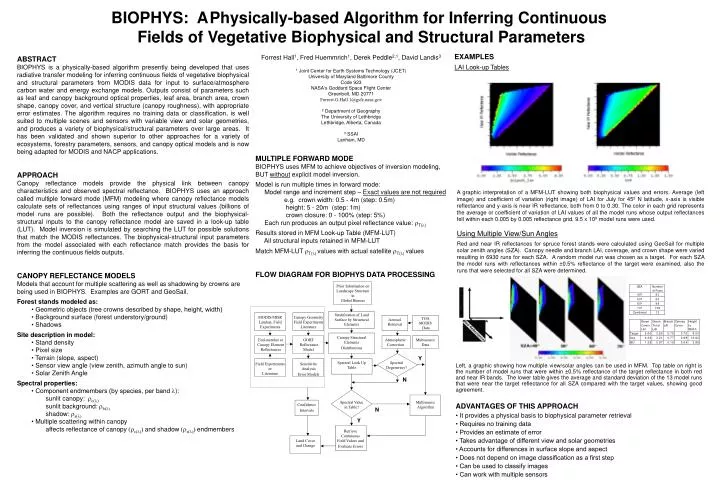
Prior Information on Landscape Structure in Global Biomes Stratification of Land Surface by Structural Elements MODIS/MISR Landsat, Field Experiments Canopy Geometry Field Experiments Literature TOA MODIS Data Aerosol Retrieval Canopy Structural Elements Distributions End-member or Canopy Element Reflectances GORT Reflectance Model Atmospheric Correction Multisource Data Y Spectral Look Up Table Spectral Degeneracy? Field Experiments or Literature Sensitivity Analysis Error Models N Spectral Value in Table? Multisource Algorithm Confidence Intervals N Y Retrieve Continuous Field Values and Evaluate Errors Land Cover and Change BIOPHYS: APhysically-based Algorithm for Inferring Continuous Fields of Vegetative Biophysical and Structural Parameters EXAMPLES LAI Look-up Tables Forrest Hall1, Fred Huemmrich1, Derek Peddle2,1, David Landis3 1 Joint Center for Earth Systems Technology (JCET) University of Maryland Baltimore County Code 923 NASA's Goddard Space Flight Center Greenbelt, MD 20771 Forrest.G.Hall.1@gsfc.nasa.gov 2 Department of Geography The University of Lethbridge Lethbridge, Alberta, Canada 3 SSAI Lanham, MD ABSTRACT BIOPHYS is a physically-based algorithm presently being developed that uses radiative transfer modeling for inferring continuous fields of vegetative biophysical and structural parameters from MODIS data for input to surface/atmosphere carbon water and energy exchange models. Outputs consist of parameters such as leaf and canopy background optical properties, leaf area, branch area, crown shape, canopy cover, and vertical structure (canopy roughness), with appropriate error estimates. The algorithm requires no training data or classification, is well suited to multiple scenes and sensors with variable view and solar geometries, and produces a variety of biophysical/structural parameters over large areas. It has been validated and shown superior to other approaches for a variety of ecosystems, forestry parameters, sensors, and canopy optical models and is now being adapted for MODIS and NACP applications. APPROACH Canopy reflectance models provide the physical link between canopy characteristics and observed spectral reflectance. BIOPHYS uses an approach called multiple forward mode (MFM) modeling where canopy reflectance models calculate sets of reflectances using ranges of input structural values (billions of model runs are possible). Both the reflectance output and the biophysical-structural inputs to the canopy reflectance model are saved in a look-up table (LUT). Model inversion is simulated by searching the LUT for possible solutions that match the MODIS reflectances. The biophysical-structural input parameters from the model associated with each reflectance match provides the basis for inferring the continuous fields outputs. CANOPY REFLECTANCE MODELS Models that account for multiple scattering as well as shadowing by crowns are being used in BIOPHYS. Examples are GORT and GeoSail. Forest stands modeled as: • Geometric objects (tree crowns described by shape, height, width) • Background surface (forest understory/ground) • Shadows Site description in model: • Stand density • Pixel size • Terrain (slope, aspect) • Sensor view angle (view zenith, azimuth angle to sun) • Solar Zenith Angle Spectral properties: • Component endmembers (by species, per band): sunlit canopy:c() sunlit background:b() shadow:s() • Multiple scattering within canopy affects reflectance of canopy (c()) and shadow (s()) endmembers MULTIPLE FORWARD MODE BIOPHYS uses MFM to achieve objectives of inversion modeling, BUT without explicit model inversion. Model is run multiple times in forward mode: Model range and increment step – Exact values are not required e.g. crown width: 0.5 - 4m (step: 0.5m) height: 5 - 20m (step: 1m) crown closure: 0 - 100% (step: 5%) Each run produces an output pixel reflectance value: T() Results stored in MFM Look-up Table (MFM-LUT) All structural inputs retained in MFM-LUT Match MFM-LUT T() values with actual satellite T() values FLOW DIAGRAM FOR BIOPHYS DATA PROCESSING A graphic interpretation of a MFM-LUT showing both biophysical values and errors. Average (left image) and coefficient of variation (right image) of LAI for July for 45º N latitude, x-axis is visible reflectance and y-axis is near IR reflectance, both from 0 to 0.30. The color in each grid represents the average or coefficient of variation of LAI values of all the model runs whose output reflectances fell within each 0.005 by 0.005 reflectance grid. 9.5 x 10⁹ model runs were used. Using Multiple View/Sun Angles Red and near IR reflectances for spruce forest stands were calculated using GeoSail for multiple solar zenith angles (SZA). Canopy needle and branch LAI, coverage, and crown shape were varied resulting in 6930 runs for each SZA. A random model run was chosen as a target. For each SZA the model runs with reflectances within ±0.5% reflectance of the target were examined, also the runs that were selected for all SZA were determined. Left, a graphic showing how multiple view/solar angles can be used in MFM. Top table on right is the number of model runs that were within ±0.5% reflectance of the target reflectance in both red and near IR bands. The lower table gives the average and standard deviation of the 13 model runs that were near the target reflectance for all SZA compared with the target values, showing good agreement. ADVANTAGES OF THIS APPROACH • It provides a physical basis to biophysical parameter retrieval • Requires no training data • Provides an estimate of error • Takes advantage of different view and solar geometries • Accounts for differences in surface slope and aspect • Does not depend on image classification as a first step • Can be used to classify images • Can work with multiple sensors