Download
1 / 48
510 likes | 791 Views
Geomorphic Description System (GDS). Phil Schoeneberger Doug Wysocki NRCS - Lincoln, NE.

E N D
Geomorphic Description System (GDS) Phil Schoeneberger Doug Wysocki NRCS - Lincoln, NE
Objectives :Explain the GDS logic and arrangement of geomorphic processes and features. Describe how the GDS is incorporated into NRCS soil map units and databases. Construct systematic soil geomorphic descriptions using GDS.
GEOMORPHIC DESCRIPTION SYSTEM Version 4.2 03 / 01 / 2012
Geomorphic Description System - GDS GDS Version 4.2 ,03 / 2012 Field Book for Describing & Sampling Soils (ver. 3.0) NSSH, Part 629 (Amendment 24, April, 2013)
“Region” Systems MLRA Rucksack: Landuse, Crops, Physio., whiff of Geom. Ecoregions Ecosystems: Plant communities Don’t correlate to physiographic, soil breaks (e.g. continental glacial boundary). Transient (climate, fire) Physiographic Regions Physical Attributes: Geology, topo., geography, climate Soils correlate best to physiographic breaks (e.g. continental glacial boundary). Less Transient
GDS PART I : PHYSIOGRAPHIC LOCATION Where and what? = geography PART II : GEOMORPHIC DESCRIPTION What and how? PART IlI : SURFACE MORPHOMETRY Form and components GDS, p. 9
GDS PART I :PHYSIOGRAPHIC LOCATION A) PHYSIOGRAPHIC DIVISION B) PHYSIOGRAPHIC PROVINCE C) PHYSIOGRAPHIC SECTION D) STATE PHYSIOGRAPHIC LOCATION E) LOCAL PHYSIOGRAPHIC NAME Fenneman 1931, 1938 GDS, p. 14
Fenneman(1931, 1938 - 1957) Adv.: • Comprehensive, detailed work with map • Shows hydrology network • Widely known geomorphic regions Disadv.: • Small scale 1 : 7,000,000 • Dated (Davisian concepts) • Some boundaries uncertain • AK, HI, & US territories not included
PART I : PHYSIOGRAPHIC LOCATIONEx.: Lincoln, NE : 12e A) PHYSIOGRAHIC DIVISION INTERIOR PLAINS B) PHYSIOGRAPHIC PROVINCE 12. CENTRAL LOWLAND PROVINCE C) PHYSIOGRAPHIC SECTION e) Dissected Till Plains f ) Osage Plains GDS, p. 16
Lincoln, NE area 12 e. Dissected Till Plains [ Submaturely to maturely dissected till plains. ] 12 f. Osage Plains [ Old scarped plains, beveling, faintly inclined strata; main streams are entrenched ]. GDS, p. 16
GDS PART I : PHYSIOGRAPHIC LOCATION A) PHYSIOGRAHIC DIVISION B) PHYSIOGRAPHIC PROVINCE C) PHYSIOGRAPHIC SECTION D) STATE PHYSIOGRAPHIC LOCATION E) LOCAL PHYSIO. / GEOGRAPH. NAME
GDS PART I : PHYSIOGRAPHIC LOCATION Where and what? PART II :GEOMORPHIC DESCRIPTION What and how? PART IlI : SURFACE MORPHOMETRY Form and components.
GDS PART Il : GEOMORPHIC DESCRIPTION A) LANDSCAPE B) LANDFORM 1) Single Landform point data, single landforms 2) Multiple Landforms i ) Landform on a Landformnested – map units ii ) Multiple Landforms map units, components, OSDs C) MICROFEATURE D) ANTHROPOGENIC FEATURE GDS, p. 11
GDS PART Il : GEOMORPHIC DESCRIPTION l) COMPREHENSIVE LISTS* A) LANDSCAPE B) LANDFORM C) MICROFEATURE D) ANTHROPOGENIC FEATURE ll) GEOMORPHIC ENVIRONMENTS and OTHER GROUPINGS LISTS GDS, p. 26
alluvial plain AA alluvial plain remnant AR badlands BA bajada (also Landform) BJ barrier island BI basin BS basin floor (also Landform) BC batholith BL bay [coast] (water body, also Landform) BY bolson BO breached anticline BD breaklands BR breaks (also Landform) BK caldera (also Landform) CD canyonlands CL coastal plain ( also LF )CP cockpit karst CPK . . . drumlin fieldDF etc. kegel karst KK lagoon (water body; also Landform) LG lake plain (also Landform) LP lava field (also Landform) LF lava plain ( also Landform )LV lava plateau(also Landform) LL lowland LW marine terrace (also Landform)MT meander belt MB mountain range MR mountains (singular = Landform) MO mountain system MS ocean (water body) OC outwash plain (also Landform) OP peninsula PE piedmont PI piedmont slope PS plains PL etc. A) Landscapes broad or unique assemblage of natural, spatially associated landforms GDS, p. 27
NSSH – Part 629: Glossary of Landforms and Geologic Terms Landscapes drumlin field – Groups or clusters of closely spaced drumlins or drumlinoid ridges, distributed more or less en echelon, and commonly separated by small, marshy tracts or depressions. SW
drumlin field– Groups or clusters of closely spaced drumlins or drumlinoid ridges, distributed more or less en echelon, and commonly separated by small, marshy tracts or depressions.
aa lava flow ALF alas AA alluvial cone AC alluvial fan AF alluvial flat AP alpine glacier AG anticline AN areteAR arroyo AY ash field AQ ash flow AS atoll AT avalanche chute AL axial stream AX back-barrier beach BBB back-barrier flat BBF backshore AZ etc. breaks (also Landscape) BK breached anticline BRL broad interstream divide BID butte BU caldera (also Landscape)CD canyon CA canyon bench CYB canyon wall CW Carolina Bay CB channel (also Microfeature) CC chenier CG chenier plain CH cinder cone CI cirque CQ cirque floor CFL … collapsed ice-walled lakebedCN etc. B) Landforms ( discrete, natural, individual earth-surface features mappable at common scales ) GDS, p. 28
NSSH – Part 629: Glossary of Landforms and Geologic Terms Landforms collapsed ice-walled lakebed - A lakebed that formed in a lake bounded by stagnant ice, but floored by solid ground, usually till. Collapse features are limited to the lakebed margins. Presently, these materials and sedimentary structures generally occur as roughly circular - shaped hills of till capped by lacustrine sediments, generally at elevations higher than surrounding disintegration moraine. Compare - collapsed ice-floored lakebed, collapsed lake plain. NSSH, Part 629
Schoeneberger Landscape: till plain central ND
What are the types and features of the sediments likely to be in these locations? ? ? ? Schoeneberger Landscape: till plain ; Landform: collapsed ice-walled lakebed on a disintegration moraine ; central ND
bar BA channel (also Landform)CH closed depression (also LF)CD cordaCO cutter CU dune slack(also Landform)DS dune traces DT earth pillar EP ephemeral stream (also LF)ES finger ridge FR flute ( also LF )FL frost boil FB glacial groove GG groove GR etc. pool(also water body) POO pothole (also LF)PH rib RB rill RL ripple mark RM rise (also Landform)RIS rockfall (also Landform) ROF roche moutonnée (also LF) POC sag (also Landform) SAG sag pond (also Landform) SP sag pond (water body; also Landform) SP salt pond (water body; also Landform) WQ sand boil SB seep (also Landform)SE etc. C) Microfeatures (discrete, natural, earth-surface features typically too small to delineate at soil survey scales ) 1)Common Microfeatures (not used with Landform “patterned ground” ) GDS, p.33
circle CI earth hummocks EH high-center polygons HCP ice wedge polygons IWP low-center polygons LCP non-sorted circles NSP palsa (palsen = plural) PA polygons PYG sorted circles SCI stripes STR turf hummocks TH Microfeatures ( discrete, natural, earth-surface features typically too small to delineate at soil survey scales )- continued - 2)Periglacial “patterned ground” Microfeatures 3)Other “patterned ground” Microfeatures bar and channel BC circular gilgai CG elliptical gilgai EG gilgai GI hummocks HU linear gilgai LG mima mounds MM pimple mounds PM puff PU GDS, p. 33
stripe - A type of patterned ground; one of the alternating bands of fine and coarse surface material, or of rock or soil and vegetation-covered ground, commonly found on steeper slopes. It is usually straight, but may be sinuous or branching. Compare - patterned ground. GG GSC 2002-214 Landform: patterned ground; Microfeature:stone stripes (pointing down slope); Nunavut,CAN
anthroscape ANT artificial collapsed depression ACD artificial levee AL beveled cut BC bioswaleBS borrow pit BP burial mound BM conservation terrace CT cut ( road, railroad )CUT cutbank CB ditch DI dump DU etc. impact crater IC interfurrow IF landfill (see sanitary landfill) -- leveled land LVL log landing LL middenMI openpit mineOM polder POL pond ( human-made )PO quarry QU railroad bed RRB reclaimed land RL rice paddy RP etc. D) Anthropogenic Features [ discrete, artificial (human-made), earth-surface features ] GDS Page 35
openpit mine – A relatively large depression resulting from the excavation of material and redistribution of overburden associated with surficial mining operations. Compare – quarry, surface mine. SW & GG Schoeneberger Anthropogenic Features: openpit mine, spoil piles, road bed Peabody Coal mine, Black Mesa, AZ
GDS PART Il: GEOMORPHIC DESCRIPTION l ) COMPREHENSIVE LISTS A) LANDSCAPE B) LANDFORM C) MICROFEATURE D) ANTHROPOGENIC FEATURE * ll ) GEOMORPHIC ENVIRONMENTS and OTHER GROUPINGS LISTS GDS, p. 35
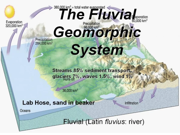
ll ) GEOMORPHIC ENVIRONMENTS and OTHER GROUPINGS E n v i r o n m e n t s • Coastal Marine & Estuarine( wave, tidal, or shallow marine related ) • Lacustrine( related to inland water bodies, non - fluvial ) • Fluvial ( related to concentrated channel flow ) • 4. Solution( dominated by dissolution & subsurface drainage ) • 5. Eolian( wind dominated ) • 6. Glacial( directly related to glaciers ) • 7. Periglacial( related to non-glacial, cold climate ) GDS, p. 26
ll ) GEOMORPHIC ENVIRONMENTS and OTHER GROUPINGS E n v i r o n. • 8. Mass Movement( gravity dominated ) • 9. Volcanic & Hydrothermal • Tectonic & Structural( bedrock structures, crustal movement ) • Slope( generic slope forms, geometry, arrangement ) • Erosional( dominated by non-channel, non - perennial water erosion ) • Depressional(low areas, declivities) • Wetlands( vegetated or shallow wet areas, wet soils ) • Water Bodies(permanent water features) • Subaqueous Features( submerged features ) O t h e r
4. SOLUTION( dominated by dissolution & subsurface drainage ) Landscapes : cockpit karst CPKkegel karst KK cone karst CK sinkhole karst SK fluviokarst FK thermokarst TK karst KP tower karst TW Landforms : blind valley VB pavement karst PAV cockpit COC pinnacle PIN collapse sinkhole CSH sinkhole SH interior valley INV solution platform SOP karst cone KC solution sinkhole SOS karst tower KTO swallow hole TB karst valley KVA thermokarst depression mogoteMOG( also Microfeature ) TK Microfeatures : cutter CUsolution pipeSOP karrenKA thermokarst depression solution chimney SCH( also Microfeature )TK etc. etc. GDS, p. 39
solution pipe – A subsurface, vertical, cylindrical or cone-shaped hole, formed by dissolution in soluble bedrock (e.g. limestone) and often without surface expression, that is filled with detrital material (e.g. soil) and which serves as a bypass route for internal water flow. R. Gavenda Anthropogenic Feature: cutbank; PM: weathered limestone; Guam
GDS PART I : PHYSIOGRAPHIC LOCATION( where? ) PART II : GEOMORPHIC DESCRIPTION( what? ) ( how? ) PART IlI :SURFACE MORPHOMETRY( pieces )
GDS PART Ill : SURFACE MORPHOMETRY A) ELEVATION(e.g. tree-line , bedrock formations) B) SLOPE ASPECT (e.g. NW-E slopes cooler, wetter ) C) SLOPE GRADIENT (e.g. kinetic energy as regards sediment ) D) SLOPE COMPLEXITY (e.g. complex vs. simple ) E) RELATIVE SLOPE SEGMENT POSITION (e.g. middle third ) F) SLOPE SHAPE (e.g. converging vs. diverging shapes ) GDS, p. 53
GDS PART Ill : SURFACE MORPHOMETRY G) HILLSLOPE - PROFILE POSITION H) GEOMORPHIC COMPONENTS : 1) HILLS 2) TERRACES , STEPPED LANDFORMS 3) MOUNTAINS 4) FLAT PLAINS I ) MICRORELIEF J ) DRAINAGE PATTERN GDS, p. 54, 55
Hillslope Profile Positions (2-D) GDS, p. 55
Geomorph. Components – Terraces , Stepped Landforms GDS, p. 56
Geomorph. Components - Flat Plains GDS, p. 57
GDS Field Checklist ? LS: LF: Microfeature: Anthro. Feature: Hillslope Position (2D): Geom. Comp. (3D): Slope Shape: Slope Gradient: Slope Complex.: Aspect: Elev.:
Site 1 Site 2
Site 1 LS: LF: Micro: Anthro. : Hill. Pos. (2D): Geom. Comp. (3D): Slope Shape: Slope Grad.: Slope Complex.: Aspect: Elev.:
Site 2 LS: LF: Micro: Anthro. : Hill. Pos. (2D): Geom. Comp. (3D): Slope Shape: Slope Grad.: Slope Complex.: Aspect: Elev.:
LS: LF: Micro.: Anthro. : Hill. Pos. (2D): Geom. Comp. (3D): Slope Shape: Slope Grad.: Slope Complex.: Aspect: Elev.: