Download
1 / 1
10 likes | 110 Views
REQUEST FOR REALIZATION OF SIMULATION FOR SPREDING OF THE OIL POLLUTION

E N D
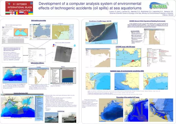
REQUEST FOR REALIZATION OF SIMULATION FOR SPREDING OF THE OIL POLLUTION Representatives of Ministry of Environment, Ministry for Emergency Response,Ministry of transport and communicationsand their divisions: oblast state environmental administration for protection of coastal oblasts, marine inspections, SSERSWOandMCERC Development of a computer analysis system of environmental effects of technogenic accidents (oil spills) at sea aquatoriums Loyeva I.D. (prof.), Lisovsky R.I., Neprokin O.O., Bratchenko O.S., Lepyoshkin A.V., Semenov V.E. Ukrainian Scientific Centre of Ecology of the Sea,Ministry for Environmental Protection of Ukraine, Odessa, Ukraine Information processing Georeference of satellite images with GIS GNOME (General NOAA Operational Modeling Environment) AIS VT Explorer For the calculations the effects of the Oil Spills, UkrSCES experts are using the model General NOAA Oіl Modelіng Envіronment (GNOME, v. 1.3.1), that allows to identify the scales of the oil pollution, quantity of oil, that were thrown to the coastline, and left in water. GNOME takes into account global sea, river and wind flow fields, type and quantity of the oil products. Data from Hydrometeorological Centre • Input data forGNOME: • Settings of simulation parameters (start date, duration) • Flow fields settings (wind, global, wind andriverflows) • Download of cartographicalunderlying layers • Data for quantity and quality indicators, localization of pollution. Distance probeEMSA CleanSeaNet GNOME usage with ESI maps WEB-interface Information delivery ArcIms ADIOS 2 GNOME Updated maps of environmental sensitivity (ESI) To display the information in the ArcMap 9.3in the form of shape files GNOME “Trajectory Import Tools” is used. Further these data are transmitted to the interactive service. The budget model of quantitative and qualitative changes in oil pollution. Data provided in the real-time movies, which reflect the distribution/change of the oil pollution. GNOME can also be used for modeling oil pollutions in the river basins. 1. There were added layers with ESI-indexes of the shoreline to the new system, that were built on the basis of the navigation maps "Tarhankut - Sevastopol, Sevastopol - Meganom, Theodosius - Anapa" (Scale 1:200 000)2. District Odessa is indexed on the basis of the navigation map, "Approaches to the ports of Odessa - Ilyichevsk - Ugnii" (Scale 1:50 000)3. Defined layers “Objects that are sensetive to oil pollution (new objects)4. Work is made on indexing the shoreline of the Azov Sea (Sea charts of the Western part of the Azov Sea and the eastern part of the Azov Sea "(Scale 1:250 000) Interactive Map Service “MES” For full functionality of the system requires information, which covers the following aspects:1. Territory of the most vulnerable and sensitive to oil pollution- Maps of environmental sensitivity (ESI)2. Marine traffic and the risk of contamination- Statistics on marine traffic (the flux density of vessels)- Statistics on accidents with oil spills for years (preferably detailed information: avrii reason, the volume of discharge, damage, etc.)3. Availability of capacity to respond to emergencies related to oil pollution- Information on port facilities and Emergency Response (skimmer, booms, etc.)- Firefighters- Aviation Processing of the nautical S-57 maps During the reporting period processed 39 sheets of nautical charts, previously acquired from UkrMorKartografiya, and converted from S-57 format in shapefiles for further use in ArcGIS, as well as in ArcIMS. UkrSCES fleet