Download
1 / 42
450 likes | 644 Views
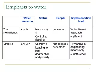
Water Resources of Turkey Emphasis on Karst. International Research Center For Karst Water Resources Hacettepe University Ankara http:\www.karst.hacettepe.edu.tr. Distribution of Precipitation Over Turkey. Annual Mean=680 mm. For the Near East: 205 mm. Climate in Turkey. Humid or Arid ?.

E N D
Water Resources of Turkey Emphasis on Karst International Research Center For Karst Water Resources Hacettepe University Ankara http:\\www.karst.hacettepe.edu.tr
Distribution of Precipitation Over Turkey Annual Mean=680 mm For the Near East: 205 mm.
Climate in Turkey Humid or Arid ?
Total Potential of Water Resources In Turkey
Who Is Water Rich and Who Is Poor? Is it only the amount ? World Water Council Water Poverty Index (WPI) 3rd Water Forum resources-access-capacity-use-environmental impact Among 147 countries Haiti Worst-Finland Best • Why WPI: Because it makes the links between • poverty, • social deprivation, • environmental integrity, • water availability and • Health • enabling the policy makers and stakeholders to identify where problems exist • and the appropriate measures to deal with their causes..
Problems Related To Water Resources in Turkey Depletion of groundwater level Loss of wetlands Polluted surface waters Polluted groundwater Salinization of coastal groundwaters Rapid and uncontrolled changes in land-use Rapid and uncontrolled growth Quantity Consequences: Quality Deficiencies ? Lack of advanced technologies? qualified personnel ? integrated approach? Institutional structure (vertical-lateral coordination)? policies based on knowledge of the phenomena? participation of the locals in planning and implementing? public awareness ?
DIRECTIVE 2000/60/EC OF THE EUROPEAN PARLIAMENT AND OF THE COUNCIL
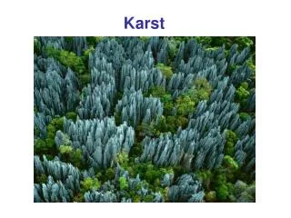
KARSTIFIED ROCKS IN TURKEY Carbonate Rocks:Metamorphic>> Paleozoic Recrystallized>> Mesozoioc Detritic with varying impurities >>Paleogene-Neogene Evaporitic: Mainly within Oligocene-Miocene Clay-Clayey Units Miocene Conglomerate: Carbonate component & matrix Carbonate rocks: Total : 1/3 of surface area Exposure: 1/5 of surface area Surface Area : 780 500 sq.km
TECTONIC STRUCTURE OF EASTERN MEDITERRANEAN REGION 1-EUROSIAN PLATE 2-AFRICAN PLATE 3-IRAN PLATE 4-SOUTH CAUCAS PLATE 5-ANATOLIAN PLATE 6-AEGEAN PLATE 7-BLACK SEA PLATE a-compressional b-extensional c- movement direction
DESCRIPTION OF TURKISH KARST Tectonics Source of Energy Gradient Lithology Type of Karst Erosion Base Control Climate Criterion:Morphology & Hydrological Function
DESCRIPTION OF TURKISH KARST • Lithology: • Petrography:Degree of Diagenesis/Content of Impurities • Thickness : Relative to erosion base controller • Mode of Existence:Authocthonous/Allochthonous • Tectonic: • Compression:contraction/extension • Tension:contraction/extension • Source of Energy Gradient: • Uplift (tectonics) • Eustatic Sea Level Changes • Interior Lake Level Changes • River Incision • Erosion Base Controller: • Sea Level • Interior Lake • River • Impervious Unit • Climate: • Wet: Cold/Hot • Dry: Cold/Hot
EARLY MIOCENE
MIDDLE MIOCENE
PRESENT PLEISTOCENE
Change in Average Elevation of the Topographic Surface since Early Miocene
EVOLUTION OF CENTRAL TAURUS- CENTRAL ANATOLIA
Lithology: Mainly dense- recrystallized (Mesozoic) Thick-to very thick authocthounous/allochthonous Tectonic: Extension+Contraction due to compression Source of Energy Gradient: rapid-very rapid uplift Erosion Base Controller: Mediterranean sea level Climate : Well pronounced effect Morphology: vertical deep-very deep-intensive to extensive Drainage: completely subsurface drainage Karst: bare-mainly recent-paleo in places Hydrogeological function: High to very high yield aquifers Extended vadoze zone+deep phreatic zone Lithology: Mainly dense- recrystallized (Mesozoic) High degree diagenesis Moderately thick-thick-authocthounous Tectonic: West Anatolian Extensional Source of Energy Gradient:Originally uplift Erosion Base Controller: Aegean Sea Level Climate : Pronounced effect controlling karstification Morphology: Sub-Verticalto vertical development Shallow / moderately deep -intensive Drainage: Subsurface drainage-capture by surface Karst: Uncovered-sumberged Hydrogeological function: High yield aquifers Extending phreatic zone by submerge