Download
1 / 13
130 likes | 222 Views
Elements to georeference data without coordinates. Case study. Some data may not have coordinates attached but only a locality name or a direction Let’s say: “Accipiter, Matadi , Bas-Congo, DRC, 1963”. New concepts.

E N D
Case study • Some data may not have coordinates attached but only a locality name or a direction • Let’s say: • “Accipiter, Matadi, Bas-Congo, DRC, 1963”
New concepts • We’ll try to assign estimated coordinates accompanied by an estimation of the error margin (error radius) • We’ll base ourselves (there) on the methodology “georeferencung for dummies” elaboratred by the University of Berkeley for the MaNIS, HerpNET and Ornis project (also recommended by GBIF and Arthur Chapman • http://www.herpnet.org/herpnet/documents/georeffordummy.xls
New concepts • Uses the Georeferencing Calculator (Applet) to calculate the final error radius (combination from the gazetteer data and metadata of the Datum) • http://manisnet.org/gci2.html
Gazetteer and Voronoï • Most of time a gazetteer (list of localities and coordinates) is made up of poitn data • …while a locality in an area (polygon) • Voronoï is a possible methodology to attach extent to points
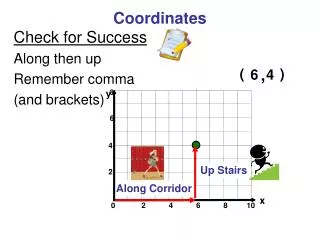
Gazetteer and Voronoï • Exercise: -Import the Congolese Gazetteer (available via DIVA GIS) into QGIS -Convert it into a shapefile -Add labels with the name of localities and localize “Matadi” (West of DRC, about 100km to the Atlantic Ocean)
Create Voronoï areas • Exercise: -Import the Congolese Gazetteer (available via DIVA GIS) into QGIS -Convert it into a shapefile -Add labels with the name of localities and localize “Matadi” (West of DRC, about 100km to the Atlantic Ocean) Lat: -5.8166 Long 13.45
Voronoï • On GIS • Vector tab • “Geometry tools” • “Voronoïpoygons” • Select the Shapefile to proceed • Declare the shapefile containing the output:
Voronoï • Output shapefile attaches areas to the localites (perpendicular to the halfways of neighbouring points)
Voronoï • Determinining the furthest point within the area is easy • Enable UTM conversion to have meter value
Voronoï • Is there any drawbacks with that method?
Voronoï • Is there any drawbacks with that method? • Do not work when a place is part of another place • The date of the gazetteer must correspond to the date of the actual original data (urbanization ois a dynamical process)