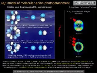
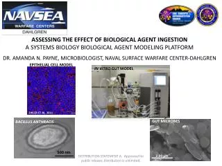
Download
1 / 21
210 likes | 398 Views
NM WAIDS. Produced Water Mapping and Tools for New Mexico Oil and Gas Producers. Contact info: Martha Cather 505.835.5685 email: martha@prrc.nmt.edu Robert Lee 505.835.5408 email: lee @prrc.nmt.edu. Professional staff Martha Cather – Principal Investigator

E N D
NM WAIDS Produced Water Mapping and Tools for New Mexico Oil and Gas Producers Contact info: Martha Cather 505.835.5685 email: martha@prrc.nmt.edu Robert Lee 505.835.5408 email: lee@prrc.nmt.edu
Professional staff Martha Cather – Principal Investigator Abe Gundiler – Co-PI, corrosion engineer Andy Sung – Co-PI, fuzzy logic Jenny Ma – Database manager Robert Lee – Project Manager Graduate Students Anthonius Sulaiman Naomi Davidson Mingzhen Wei Dennis Xu Ajeet Peraty Nilay Engin Undergraduates Patrick Chavez Kevin Madalena Team Members
Background • Tasks • Products
Background • Work with NMOGA Chlorides Group – Requests include: • Maps of chloride content of groundwater • Maps of depth to groundwater • Work with “Water Dog” project • Group wanted a way to collect and map water quality information for produced water • Requests for a GIS that would show both water information and oil and gas information • Producer requests for help with corrosion issues
1. Database Construction Why a produced water database? Produced water costs money! Collecting data can help producers: • Plan the design of water handling and treatment systems • Evaluate the limits of alternative disposal and other use options • Evaluate the need for anti-scaling additives
1. Database Construction • Produced Water Quality Database • Created from paper and electronic data • Data includes info on location, general properties, cations, anions • Update Groundwater Database with best available data • Water well locations updated from NM State Engineer’s Office • Surface and groundwater data from USGS and EPA • Create Cultural and Infrastructure Databases • Obtain cultural data from counties where available, otherwise go to USGS or State sources • Obtain infrastructure (pipeline) data from public and OCD sources (this may be a problem because of homeland security issues)
Produced Water Database • Database has about ~8000 samples statewide that have both a location and chemistry data. • Currently have about 4200 samples for southeast New Mexico that have both location and some kind of water chemistry data Most data is in Lea County. • Initial pilot project was for Eddy and Lea counties, but database has data for entire state. We have ~3500 samples in the San Juan basin.
Produced Water Database 1500 1900 200 3448 1000
Web Entry System • Produced water samples can be entered via the web • Samples can be searched via the web • Plan is for graphical searches and dynamic maps with GIS
OCR Data Entry • Much of our data donated by companies but is on paper forms in many different formats. • Developed a workflow for scanning and converting the forms into text. • Data is then entered into the database. • Improves speed and accuracy. • Have currently entered about 3000 forms this way.
OCR Data Entry Data forms come in many formats, from many companies. Data forms may be typed, handwritten, or a combination. Copies may be blurry, skewed, or noisy. Even with these problems, forms take from 1-5 minutes to enter, providing >50% time savings and greater accuracy, plus original image is now preserved as a reference.
Groundwater Database • Data from a preliminary dataset provided by Roswell SEO • Database contains about 30,000 samples for southeast New Mexico (project pilot area). Only chemistry data is chloride and TDS. Data still needs some QC.
2. Geographic Information System (GIS) • Create Map Layers from Task 1 data • Create a Project-specific interface, w/help files • Beta-test web site • Place on external-visible web server • Create CD for non-networked applications
Water GIS Our GIS will eventually have data about both ground water and produced water quality. Information could also include volumes of water by formation, location of handling facilities, SWD wells, injection wells, etc., depending on availability of the data.
Water GIS We can examine overall trends in chloride content (or other component, should there be sufficient data)
Water GIS San Andres and Grayburg We can examine variability based on formation. May be useful for locating problem areas.
3. Fuzzy Risk Analysis Tool • Create FRAT • Present to NMOGA Chlorides Group and NMOCD for evaluation • Incorporate suggested changes, add additional parameters from API modeling study • Beta-test • Release on web site as part of the GIS
4. Corrosion and Scale Management Toolkit • Collect corrosion information & current management practices from operators • Create a qualitative Corrosivity Index for various producing formations and regions • Assemble online reference book • Create scale prediction tools • Incorporate all information into the web site
CorrosionToolkit – Scale Calculation With special thanks to Yates Petroleum Corp for their generous help.
Deliverables • Searchable databases of produced and groundwater data • Fuzzy risk assessment tool • Corrosion toolkit • Online Geographic Information System • WAIDS Website – integration of all deliverables • We need, and would greatly appreciate contributions of produced water data from more operators – contact Martha

![Nm]](https://cdn3.slideserve.com/6300766/slide1-dt.jpg)