Download
1 / 6
90 likes | 273 Views
Robinson Map Projection. By Sydney, Brynn , Elisha, Dylan, and Kirklyn. Who Created the Robinson Projection?.

E N D
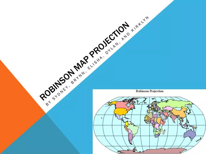
Robinson Map Projection By Sydney, Brynn, Elisha, Dylan, and Kirklyn
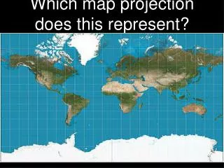
Who Created the Robinson Projection? • Arthur H. Robinson created the Robinson projection in 1963 in response to the Rand McNally companies appeal. The National Geographic Society published this projection in 1988 and it started being used more than the Van der Griten projection, but in 1998 it was replaced by the Winkel Triple projection.
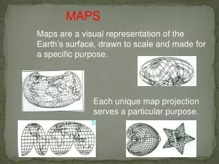
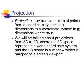
Why was this projection created? • The Robinson map projection was made by trying to find a way to accurately project the whole world on a flat image. This map was created to have a pleasing view of the world. This map is flat but roughly resembles the common depiction of the world.
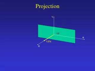
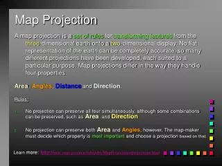
What are the benefits of this projection? • The Robinson map projection isn’t an equal-area or conformal projection. Arthur H. Robinson thought this produced a better over-all projection than both of them. The lines of longitude curve gently, avoiding extremes, and stretch the poles into long lines instead of a point. The Robinson projection is the best choice for displaying the whole earth and is commonly used for thematic maps.
Are there any problems/issues with this projection? • There is slight distortion from using the Robinson map due to these reasons: • Shearing- distortions do not extreme until you go past 450 north or south of the equator. • Tearing - the latitude and longitude start out strait then curve as you move away from the maps central meridian • Compression – the Robinson map suffers from slight compression. It has low distortion with 450 of the equator. • Shapes are also distorted because the Robinson is not truly conformal.
Sources • http://en.wikipedia.org/wiki/Robinson_projection • http://www.google.ca/imgres?q=who+created+the+robinson+projection&hl=en&client=firefox-a&sa=X&rls=org.mozilla:en-US:official&biw=1600&bih=790&tbm=isch&prmd=imvns&tbnid=De_JWfhdmBCl-M:&imgrefurl=http://www.personal.psu.edu/rul135/geog482/project_1/p1_base.html&docid=kRDkiWGWtrOjvM&imgurl=http://www.personal.psu.edu/rul135/geog482/project_1/Robinson_CM0_full_ext.png&w=500&h=500&ei=R9RtULr9NYmkiQKjnYHADg&zoom=1&iact=hc&vpx=180&vpy=137&dur=3068&hovh=225&hovw=225&tx=97&ty=113&sig=117557118099074198099&page=1&tbnh=141&tbnw=141&start=0&ndsp=28&ved=1t:429,r:0,s:0,i:71 • http://www.nytimes.com/2004/11/15/obituaries/15robinson.html?_r=1 • http://www.nytimes.com/2004/11/15/obituaries/15robinson.html?_r=1 • http://www.google.ca/imgres?q=Robinson+projection&hl=en&client=firefox-a&rls=org.mozilla:en-US:official&biw=1600&bih=790&tbm=isch&tbnid=eysF_PePLOyktM:&imgrefurl=http://www.lib.berkeley.edu/EART/arcview.html&docid=CC58q21X7of2VM&imgurl=http://cluster3.lib.berkeley.edu/EART/images/robinso2.gif&w=551&h=316&ei=INVtUJTdKcTVigKswICIBQ&zoom=1&iact=hc&vpx=157&vpy=478&dur=2267&hovh=170&hovw=297&tx=170&ty=118&sig=117557118099074198099&page=1&tbnh=98&tbnw=171&start=0&ndsp=29&ved=1t:429,r:15,s:0,i:129 • www.geography.wise.edu/maplib/robinson_projection.html